
Juggernaut Mobilizes for Drilling on Midas, Empire and Bingo Properties in Golden Triangle, B.C.
Juggernaut Exploration Ltd (JUGR-TSXV) (OTCQB-JUGRF) (FSE-4JE) (the “Company” or “Juggernaut”) is pleased to report early mobilization for the 2023 drilling season on its 100% controlled Midas, Empire and Bingo properties. The Company has a total of ~6,500 meters of drilling planned on the three properties in world class geologic terrane with multiple maiden drilling targets all with strong discovery potential.
Dr. Quinton Hennigh, Special Technical Advisor to the Company and technical consultant for all Crescat Capital gold and silver mining investments stated “We are delighted to see Juggernaut move toward drilling at Midas and Empire. Given the nature of the targets, potentially high grade and large, and the recent positive trend in the commodity space, Juggernaut is set to be one of the most exciting exploration stories in BC this year. Having reviewed the drill plans, I am quite confident that they could make two notable discoveries this season.” (Link to Crescat 19.70% News Release from May 12, 2023)
BINGO PROPERTY 100% CONTROLLED – FULLY PERMITTED AND DRILL READY
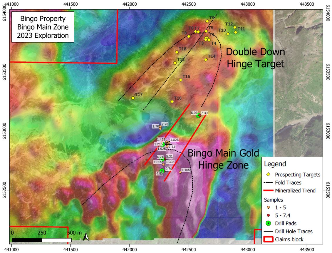
The Bingo Main Zone is a drill ready zone containing gold mineralized grab, chip and channel samples along the axial plane of a fold hinge over an area of 550 meters x 175 meters in a region of recent glacial retreat and permanent snowpack abatement located within the Eskay Rift region of the Golden Triangle, British Columbia. High-grade gold from surface grab samples assayed up to 9.79 gpt Au. Channel samples assayed up to 1.77 gpt Au and 0.20 % Cu over 4.85 meters and 1.48 gpt Au and 0.37 % Cu over 3.2 meters, respectively. A second sister hinge zone has been identified approximately 1 km to the north (named the “Double Down” hinge zone) as strongly indicated by both lidar and geophysics that will be tested in 2023. The Bingo property has strong similarities to Goliath Resources’ Surebet Project located further to the east, including same mineralogy, lithology, textures and structures.
The 2023 field program on the 100% controlled Bingo property consists of up to ~1800 m of drilling from 4 drill pads within the Bingo Main zone. Drilling on the Bingo Main Zone is anticipated to start in August 2023. Additional surface exploration work will be undertaken to better understand the folded system at play on Bingo by mapping and prospecting of the “Double Down” hinge zone located 1 km to the north of the Bingo Main Zone and believed to be part of the same mineralizing system.
Highlights from the high-grade gold Bingo property:
- The Bingo Main zone has been expanded from 320 meters by 175 meters to 550 meters by 175 m and remains open with high-grade gold samples located along the axial plane of a fold hinge that assayed up to 9.79 gpt Au.
- An additional hinge zone named the “Double Down” hinge zone with similar characteristics is located 1 km to the north.
- Bingo is located in the Eskay Rift in an evolving gold district in a world-class geologic setting within the Golden Triangle of British Columbia, host to several multi-million-ounce gold deposits.
- Bingo contains the same world-class geological units as Goliath Resource’s Surebet discovery, including Hazelton Volcanics and related sediments and intrusives.
- Gold mineralization in outcrop, stream sediment geochemistry, ground magnetic survey, soil sampling and other lines of evidence confirm strong gold-mineralization on the property.
- Mineralization is characterized by pyrite, chalcopyrite, galena and pyrrhotite.
- Gold-rich fluids intruded and altered the host rock indicating a shear zone.
- The Bingo property is surrounded by a number of known deposits, including Anyox, Surebet, Dolly Varden, Porter Idaho, Premier, and more.
- Infrastructure includes direct access to tide water in close proximity to roads and high-tension power.
The Bingo property has an area of 989 hectares and is located 45 km SSW of Stewart, BC and 28 km W of Kitsault, and only 12 km to tidewater landing and roads in the historic mining town of Anyox providing for cost effective exploration.
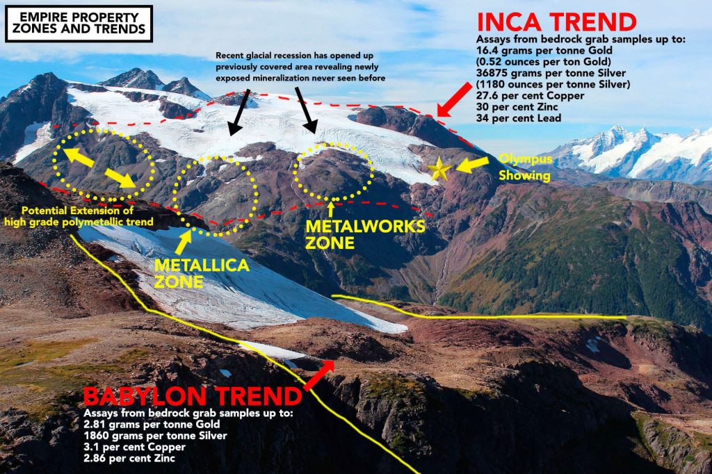
EMPIRE PROPERTY 100 % CONTROLLED – HIGH GRADE METALLICA ZONE PORPHYRY TARGET – FULLY PEMITTED AND DRILL READY
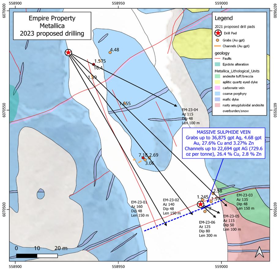
The Metallica zone on the Empire property is a new discovery in a region of recent glacial retreat exposing mineralized outcrop that has never been seen before located at the southern end of the Golden Triangle, British Columbia. Limited prospecting identified mineralization over an area measuring approximately 250 by 225 meters that remains open. Grab samples from an outcropping massive sulphide vein up to 30 cm wide assayed up to 36,875 gpt Ag (1180 ounces per ton silver), 4.68 gpt Au, 27.6% Cu and 3.27% Zn (This is one of the highest silver samples collected from outcrop in Canadian history). Channel samples from the massive sulphide vein assayed 22,694 gpt Ag (729.6 oz per ton), 26.4 % Cu, 2.8 % Zn. The vein extends for 40 meters in an east-west direction indicating a large porphyry feeder system at depth that remains open and is drill ready. Five separate gently dipping veins assayed between 1.00 and 16.4 gpt Au, and up to 2470 gpt Ag, 15.45% Cu and 1.58% Zn. These veins are up to 30 cm wide, contain quartz + Fe-carbonate ± covellite ± sphalerite and are arranged in a traceable set for over 50 meters across strike. In close proximity potassic alteration and porphyry textures seen on surface are believed to be related to a subtle magnetic high, indicating a porphyry core feeder at depth.
The 2023 drill program will test these veins including the massive sulphide veins and the potentially underlying porphyry feeder system with ~1200 m of drilling from 2 drill pads. Drilling on the Empire Metallica Zone is anticipated to begin in August 2023.

Highlights from the high-grade Metallica Zone porphyry target on the Empire property:
- Grab samples from a massive sulphide vein up to 30 cm wide assayed up to 36,875 gpt Ag (1180 ounces per ton), 4.68 gpt Au, 27.6% Cu and 3.27% Zn. Channel samples from the massive sulphide vein assayed 22,694 gpt Ag (729.6 oz per ton), 26.4 % Cu, 2.8 % Zn. The vein extends for 40 meters in an east-west direction and remains open.
- Five separate gently dipping veins assayed between 1 and 16.4 gpt Au, and up to 2470 gpt Ag, 15.45% Cu and 1.58% Zn. These veins are up to 30 cm wide, contain quartz + Fe-carbonate ± covellite ± sphalerite and are arranged in a traceable set for over 50 meters across strike and remains open.
- Mineralization is hosted within a propylitically altered feldspar porphyry unit.
- The Metallica zone is part of the Inca Trend, a high-grade polymetallic mineralized trend that extends for 1.6 by 1.2 kilometer in an area where recent glacial abatement has exposed several extensive new zones of mineralized outcrop which were previously unknown.
- Excellent proximity to infrastructure, including highway, railway, high-tension power and the town of Terrace, BC.
The 100% controlled Empire Property covers 12,480 hectares approximately 70 kilometers northeast of Terrace, BC. It is road-accessible and approximately 15 kilometers from the nearest highway and power line.
MIDAS PROPERTY 100 % CONTROLLED – ESKAY STYLE VHMS TARGET – FULLY PEMITTED AND DRILL READY
The Midas property is located in an area of recent glacial abatement and permanent snowpack recession at the southern end of the Golden Triangle, British Columbia. Multiple high-grade gold grab, chips and channel samples were collected from the Kokomo VHMS target where a 1.00 m chip sample assayed 9.343 gpt Au, 117 gpt Ag, 1.58 % Cu and 1.77 % Zn and is drill ready. Relatively shallow Induced Polarization (IP) chargeability and resistivity anomaly extends under the Kokomo showing on trend to the south for at least 850 meters towards the VG Zone, conducive for a buried VHMS containing semi-massive to massive sulphides at depth. Channel samples highlights from the VG Zone include 10.28 gpt Au over 4.34 meters; 15.37 gpt Au over 2 meters; and 5.43 gpt Au over 3.11 meters. Historic drill results from the Midas property include hole MD-18-16 which intersected the peripheral zone of the IP anomaly core and returned 0.56 g/t AuEq over 35.35 meters; hole MD-18-08, which assayed 6.85 gpt Au over 9 meters and narrowly missed a strong IP chargeability anomaly; and hole MD-18-01 which intersected 3.27 gpt AuEq over 4.80 meters and ended before it reached the core of a strong IP chargeability anomaly.
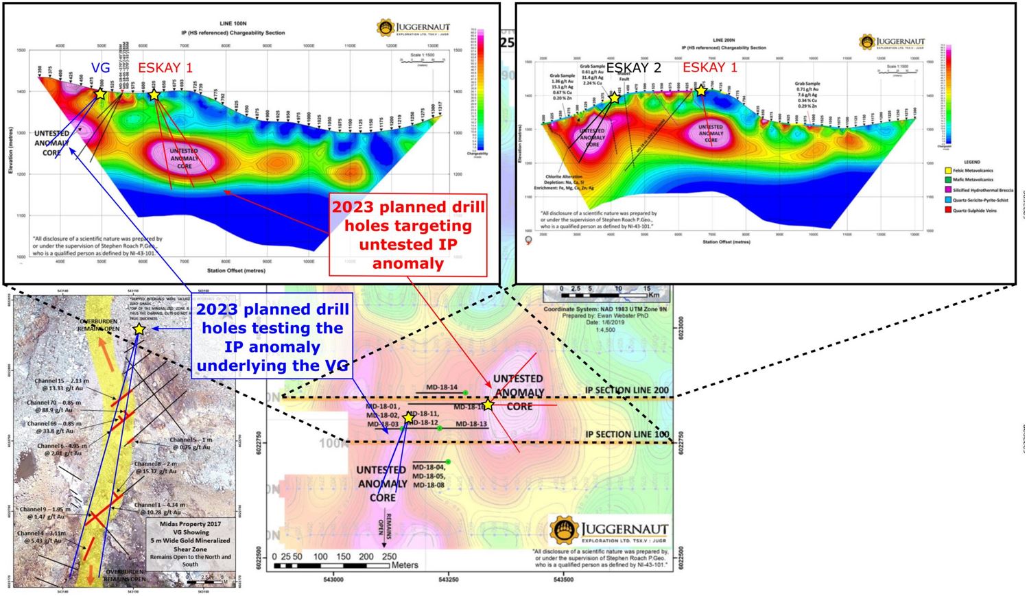
A series of 5 drill targets have been identified in association with the surface mineralization and the subsurface geophysical IP data on the Midas property along the 850 meter south trending anomaly connecting the Kokomo target with the VG Zone. These targets will be drill tested with 3500 meters of drilling from 6 pads. Drilling on the Midas property is anticipated to begin in July 2023.
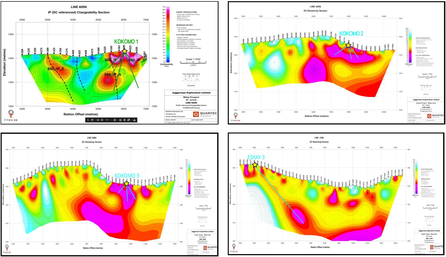
Highlights from the Midas property:
- Historic drill results from the Midas property include hole MD-18-16 which intersected the peripheral zone of the IP anomaly and returned 0.56 g/t AuEq over 35.35 meters; hole MD-18-08, which assayed 6.85 gpt Au over 9 meters and narrowly missed a strong IP chargeability anomaly core; and hole MD-18-01 which intersected 3.27 gpt AuEq over 4.80 meters and ended before it reached the core of a strong IP chargeability anomaly.
- Channel samples highlights from the VG Zone include 10.28 gpt Au over 4.34 meters; 15.37 gpt Au over 2 meters; and 5.43 gpt Au over 3.11 meters.
- Multiple high-grade gold grab, chips and channel samples including Kokomo showing where a 1 m chip sample assayed 9.343 gpt Au, 117 gpt Ag, 1.58 % Cu and 1.77 % Zn.
- Relatively shallow Induced Polarization (IP) chargeability and resistivity anomaly extends under the Kokomo showing for at least 850 meters on trend to the south conducive for semi-massive to massive sulphides.
- Alteration zones extracted from Worldview 3 satellite spectral data show a strong silica, iron and phyllic alteration (quartz-sericite-pyrite) signature overlapping the Kokomo showing and the 850-meter trend immediately to the south and east coinciding with the IP anomaly in the subsurface, further indicating the presence of a mineralized VHMS system at depth.
- Regional and local geology is highly prospective for VHMS deposits including the presence of a rhyolitic tuff with strong phyllic alteration (quartz-sericite-pyrite) from the Mt Attree volcanics which are Mississippian in age. Mississippian age rocks are known to host the majority of significant VHMS deposits.
- Widespread Zn signature with secondary Au, Ag, Pb, Cu and trace element signature (elevated Au, Te, As, Sb, Bi, Cd, Hg, Ba).
- Midas is within a world class geologic setting with strong potential for Eskay-style VHMS mineralization.
The Midas property is 100% controlled and covers 20,803 hectares and is located 24 km southeast of Terrace, British Columbia in close proximity to logging access roads, power, railway and major infrastructure.
Dan Stuart, President and CEO of Juggernaut Exploration states “We are excited to begin maiden drilling on new targets on all three of our 100% controlled properties, namely Midas, Empire and Bingo. We designed what we believe are strong drill plans for all of the strong targets with world class discovery potential in areas that have not been drill tested before. The planned program that will consist of ~6,500 meters of drilling has commenced early this year due to exceptionally good weather across Northwestern B.C. With much anticipation, we look forward to executing the inaugural drill and exploration programs and reporting results.”
Qualified Person
Rein Turna P. Geo is the qualified person as defined by National Instrument 43-101, for Juggernaut Exploration projects, and supervised the preparation of, and has reviewed and approved, the technical information in this release.
Other
Grab, channels, chip and talus samples were collected by foot with helicopter assistance. Prospective areas included, but were not limited to, proximity to MINFile locations, placer creek occurrences, regional soil anomalies, and potential gossans based on high-resolution satellite imagery. The rock grab and chip samples were extracted using a rock hammer, or hammer and chisel to expose fresh surfaces and to liberate a sample of anywhere between 0.5 to 5.0 kilograms. All sample sites were flagged with biodegradable flagging tape and marked with the sample number. All sample sites were recorded using hand-held GPS units (accuracy 3-10 meters) and sample ID, easting, northing, elevation, type of sample (outcrop, subcrop, float, talus, chip, grab, etc.) and a description of the rock were recorded on all-weather paper. Samples were then inserted in a clean plastic bag with a sample tag for transport and shipping to the geochemistry lab. QA/QC samples including blanks, standards, and duplicate samples were inserted regularly into the sample sequence at a rate of 10%.
All samples, including rock grabs, channels, and talus samples, are transported in rice bags sealed with numbered security tags. A transport company takes them from the core shack to the ALS labs facilities in North Vancouver. ALS is either certified to ISO 9001:2008 or accredited to ISO 17025:2005 in all of its locations. At ALS samples were processed, dried, crushed, and pulverized before analysis using the ME-MS61 and Au-SCR21 methods. For the ME-MS61 method, a prepared sample is digested with perchloric, nitric, hydrofluoric and hydrochloric acids. The residue is topped up with dilute hydrochloric acid and analyzed by inductively coupled plasma atomic emission spectrometry. Overlimits were re-analyzed using the ME-OG62 and Ag-GRA21 methods (gravimetric finish). For Au-SCR21 a large volume of sample is needed (typically 1-3kg). The sample is crushed and screened (usually to -106 micron) to separate coarse gold particles from fine material. After screening, two aliquots of the fine fraction are analysed using the traditional fire assay method. The fine fraction is expected to be reasonably homogenous and well represented by the duplicate analyses. The entire coarse fraction is assayed to determine the contribution of the coarse gold.
Some of the reported data is historical in nature and is a compilation of third-party data from previous operators. The reader is cautioned that grab samples are spot samples which are typically, but not exclusively, constrained to mineralization. Grab samples are selective in nature and collected to determine the presence or absence of mineralization and are not intended to be representative of the material sampled. In addition, the reader is cautioned that proximity to known mineralization does not guarantee similar mineralization will exist on the properties.
For more information, please contact:
Juggernaut Exploration Ltd.
Dan Stuart
President, Chief Executive Officer and Director
Tel: (604)-559-8028
NEITHER THE TSX VENTURE EXCHANGE NOR ITS REGULATION SERVICES PROVIDER (AS THAT TERM IS DEFINED IN THE POLICIES OF THE TSX VENTURE EXCHANGE) ACCEPTS RESPONSIBILITY FOR THE ADEQUACY OR ACCURACY OF THIS RELEASE.
FORWARD LOOKING STATEMENT
Certain disclosure in this release may constitute forward-looking statements that are subject to numerous risks and uncertainties relating to Juggernaut’s operations that may cause future results to differ materially from those expressed or implied by those forward-looking statements, including its ability to complete the contemplated private placement. Readers are cautioned not to place undue reliance on these statements.
NOT FOR DISSEMINATION IN THE UNITED STATES OR TO U.S. PERSONS OR FOR DISTRIBUTION TO U.S. NEWSWIRE SERVICES. THIS PRESS RELEASE DOES NOT CONSTITUTE AN OFFER TO SELL OR AN INVITATION TO PURCHASE ANY SECURITIES DESCRIBED IN IT.