
Sun Summit Drills 23.5 Meters of 4.35 g/t Gold Including 4.50 Meters of 21.8 g/t Gold at the JD Project; Extends Creek Zone Mineralization 100 Meters Along Strike
Sun Summit Minerals Corp. (TSXV: SMN) (OTCQB: SMREF) (“Sun Summit” or the “Company”) is pleased to report assay results from the first thirteen drill holes at the Creek Zone, part of its 2026 drill program at the Company’s JD Project, Toodoggone Mining District, north-central British Columbia (the “JD Project“).
The 2026 drill program at the JD Project consisted of 16,000 meters in 55 drill holes across the Creek, Finn and Schmitt zones (see September 15th, 2026, News Release). Drilling was designed with two primary goals: (1) establish inaugural mineral resource estimates for the Creek, Finn and Schmitt zones, and (2) explore the lateral and vertical extents of near surface, epithermal-related gold-silver-base metal mineralization at all three targets.
Drilling at the Creek Zone successfully extended high-grade and bulk-tonnage style, epithermal-related gold-silver mineralization by approximately 100 meters along strike to the northwest where it remains open. Assay results are pending from the remaining 42 holes completed during the 16,000-meter 2026 drill program.
Highlights:
- Creek Zone extension: Four drill holes evaluated the strike-extent of Creek Zone mineralization. Holes were stepped out to the northwest from 2025 drilling. All reported holes intersected gold-silver mineralization, highlights include:
- 23.5 meters of 4.35 g/t Au and 4.69 g/t Ag from 109.0 meters down hole including 4.50 meters of 21.8 g/t Au and 20.18 g/t Ag in drill hole CZ-26-023
- 32.5 meters of 3.02 g/t Au and 2.53 g/t Ag from 139.0 meters down hole including 7.57 meters of 12.15 g/t Au and 9.24 g/t Ag in drill hole CZ-26-032
- 26.6 meters of 3.23 g/t Au and 11.62 g/t Ag from 138.3 meters down hole including 2.17 meters of 10.58 g/t Au and 6.51 g/t Ag in drill hole CZ-26-031; and
- 24.0 meters of 1.81 g/t Au and 2.55 g/t Ag from 126.0 meters down hole in drill hole CZ-26-029
- High-grade gold-silver mineralization: The broad zones of bulk-tonnage style mineralization are punctuated with high-grade, vein-hosted gold-silver mineralization, such as:
- 62.90 g/t Au and 46.60 g/t Ag over 1.5 meters in drill hole CZ-26-023
- 90.60 g/t Au and 15.45 g/t Ag over 0.55 meters in drill hole CZ-26-032
- 23.50 g/t Au and 173 g/t Ag over 0.80 meters in drill hole CZ-26-031
- 39.30 g/t Au and 52.20 g/t Ag over 0.96 meters in drill hole CZ-26-029
- Mineralization remains open to the northwest: Results demonstrate that the main vein-controlling structures at the Creek Zone extend to the northwest beyond the limits of previous drilling. Mineralization remains open for expansion.
- Resource guided drill program: Results from this phase of focused drilling at the Creek Zone will inform grade continuity, the down-dip and strike extents of mineralization, as well as validate historical drill data which will set the framework for an inaugural mineral resource estimate planned for Q1 of 2027.
- Additional assay results pending: Assay results from the remaining 8 Creek Zone holes as well as 19 Finn Zone holes and 15 Schmitt Zone holes will be released following receipt, verification and interpretation.
“Our third drilling campaign at the Creek Zone clearly demonstrates the scale of the mineralized hydrothermal system and, importantly, gives us a clear path toward expanding the zone,” stated Niel Marotta, CEO of Sun Summit Minerals. “The scale and intensity of alteration encountered across our drilling are highly encouraging for the style of epithermal system we are systematically testing. This work continues to demonstrate strong grade continuity across drill fences, building confidence that the mineralization remains open along strike and is consistent with previous results. These findings will help refine our geological model and inform our upcoming Mineral Resource Estimate planned for Q1 2027. We expect to receive the balance of the Creek Zone, Finn Zone and Schmitt Zone assays over the coming weeks and will provide updates as they become available.”
Expanding the Creek Zone
Twenty-one holes for approximately 7,400 meters were drilled in 2026 at the Creek Zone. The drill holes covered an area of approximately 650 by 300 meters to a vertical extent of approximately 350 meters (Figure 1). Drill holes were designed to systematically evaluate the modelled vein-controlling structures by testing the extent and continuity of near-surface, high-grade and bulk-tonnage gold mineralization on 60-to-80-meter pierce-points. Drilling followed-up significant previous results, such as 81.0 meters of 4.80 g/t gold, including 34.0 meters of 9.07 g/t gold in drill hole CZ-25-021 (November 25th, 2025, News Release).
Assay results from the first 13 drill holes completed at the Creek Zone (totalling 5,017 meters, drill holes CZ-26-022 to CZ-26-034) are reported in Table 2. Four of the holes represent step-out holes along the northwest strike-extent of the modelled structural corridor (Figure 1). These holes returned high-grade and bulk-tonnage style gold mineralization similar to mineralization intersected 100 meters to the southeast in 2025 and demonstrate the expansion potential to the northwest.
All drill holes across the Creek Zone intersected a bedded sequence of intermediate volcanic and volcaniclastic rocks interpreted to be within the lower sequence of the Metsantan Member of the Early Jurassic Toodoggone formation. Higher-grade gold mineralization is hosted in epithermal-related and locally banded quartz-carbonate veins, veinlets and sulfide-cemented breccias with locally strong potassium feldspar alteration halos. Vein-hosted sulfides include pyrite, sphalerite, ± chalcopyrite and galena with some veins containing visible gold (Figure 5). Assay results from this visible gold-bearing interval comprise 90.6 g/t Au and 15.45 g/t Ag over 0.55 meters (Table 1).
Bulk-tonnage mineralization is associated with selectively pervasive sericite-chlorite-hematite alteration with disseminated pyrite, proximal to vein-associated potassic alteration (e.g., 31.98 meters of 0.81 g/t Au with 3.64 g/t Ag from 48.5 meters downhole and 32.5 meters of 3.02 g/t Au and 2.53 g/t Ag from 139.0 meters downhole in drill hole CZ-26-032 (Figure 4) and 26.6 meters of 3.23 g/t Au and 11.62 g/t Ag from 138.31 meters down hole in drill hole CZ-26-031 (Figure 5).
Next Steps
The new drill results together with 2024 and 2025 data, provide additional support relevant to the interpretation of grade continuity within the Creek Zone. Once results from the remaining 8 Creek Zone holes are returned, the geological, structural and mineralization domain models will be updated in preparation for an inaugural mineral resource estimation anticipated in Q1 2027.
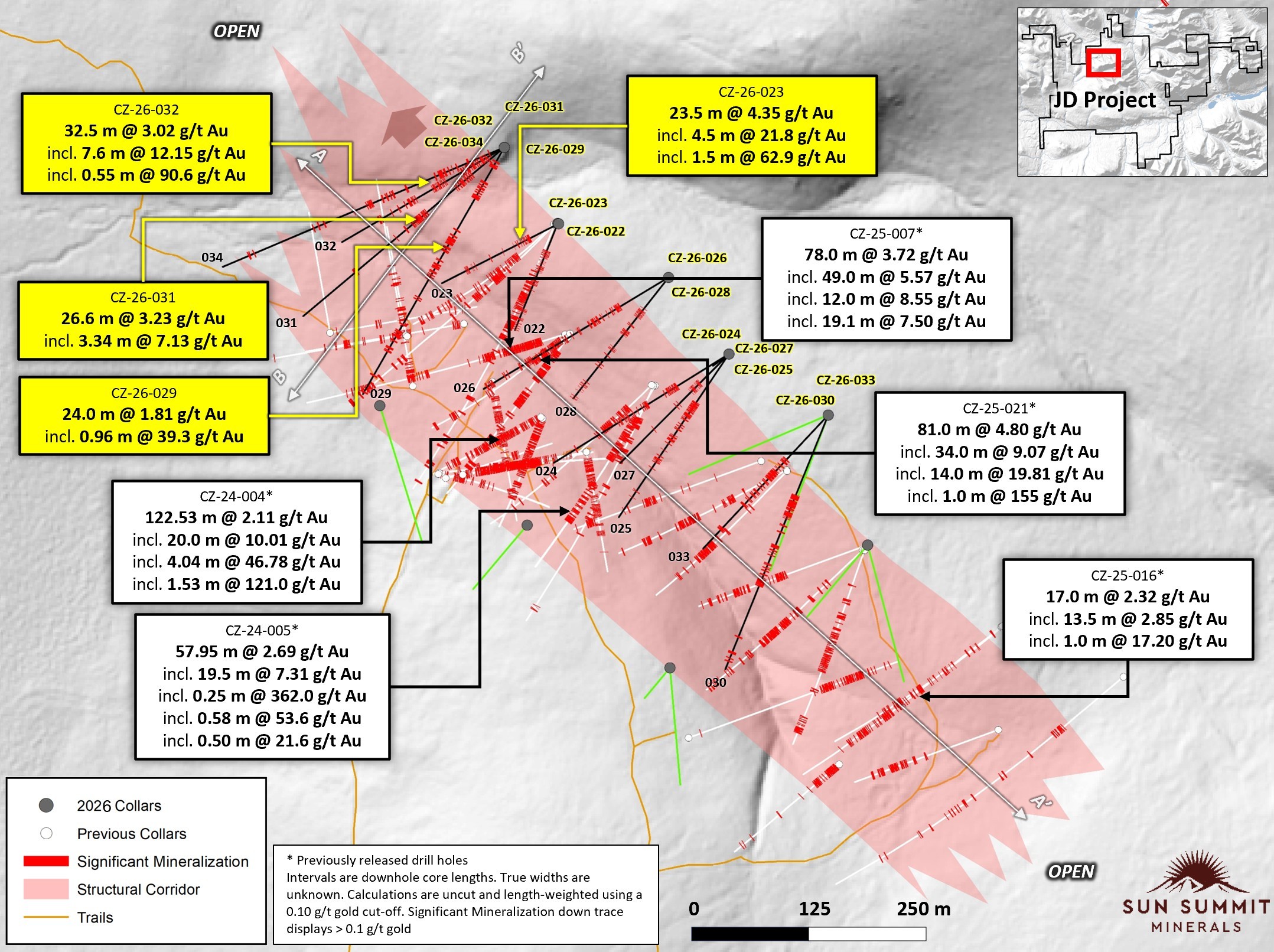
Figure 1. Plan map showing drill collar locations of all Creek Zone drill holes. Selected highlights from the 2024, 2025 and 2026 drill programs at the Creek Zone are also shown. Section lines for Figures 2 and 3 are shown. References 1 and 2 for sources of historical drill data.
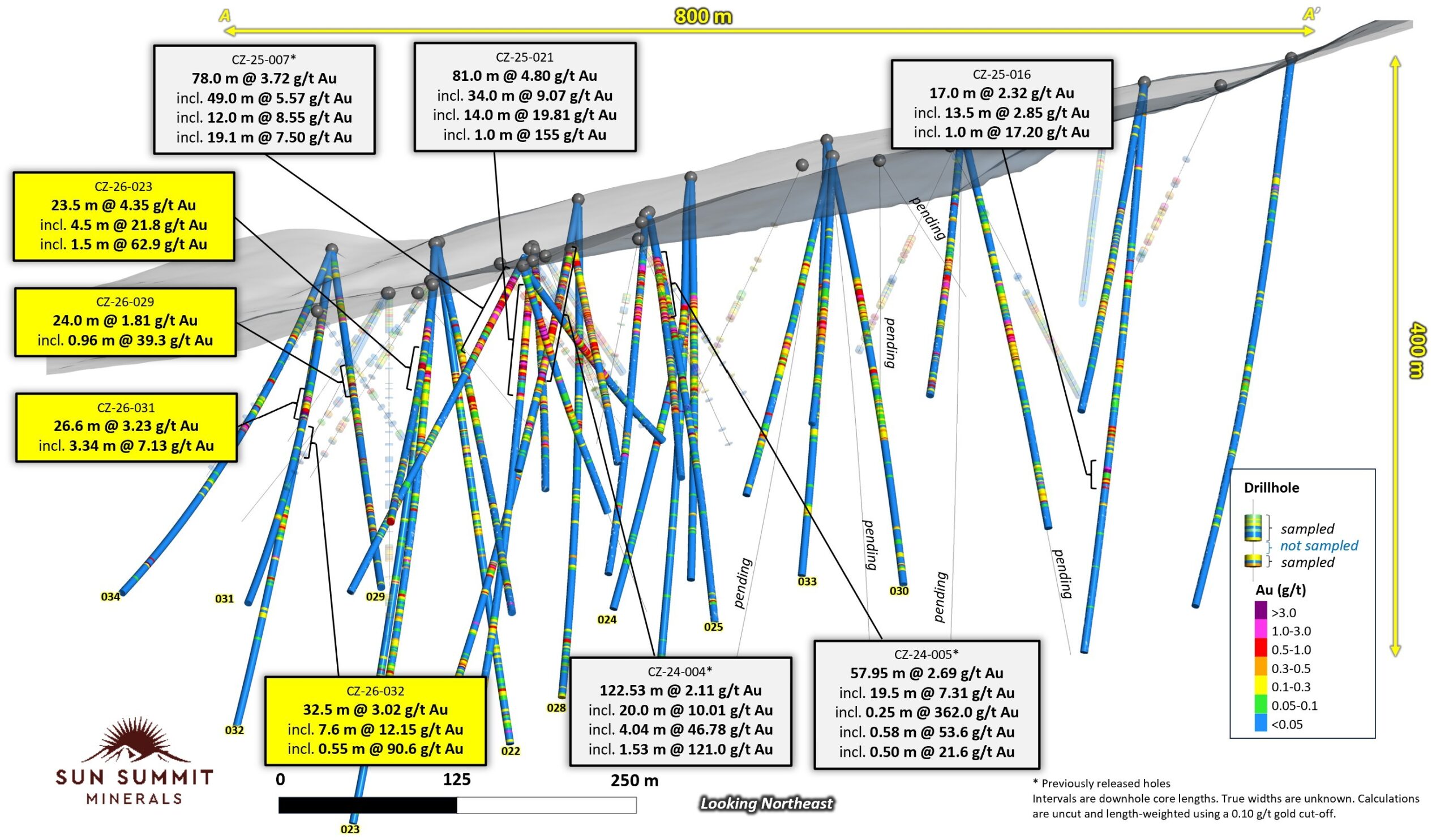
Figure 2. Oblique long section view through the Creek Zone drill holes showing downhole assays for all drill holes including CZ-26-022 to CZ-26-034. Selected highlights from the 2024, 2025 and 2026 drill programs at the Creek Zone are also shown. See references 1 and 2 for sources of historical drill data.
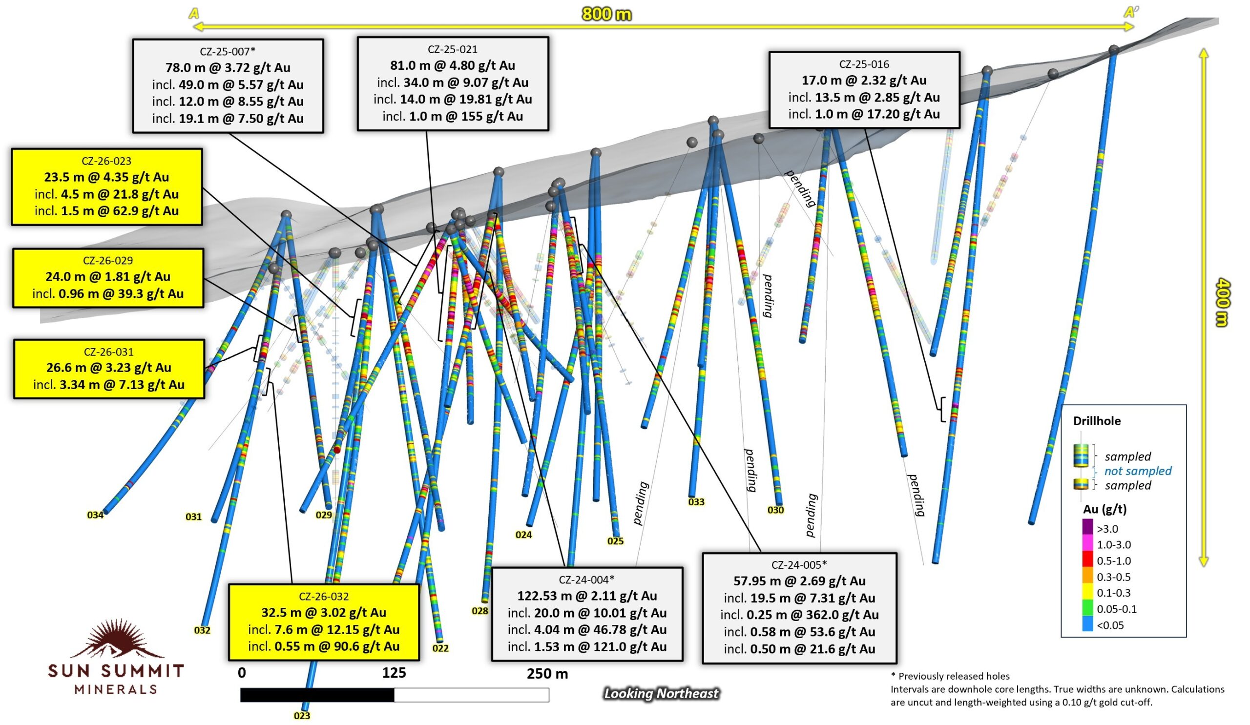
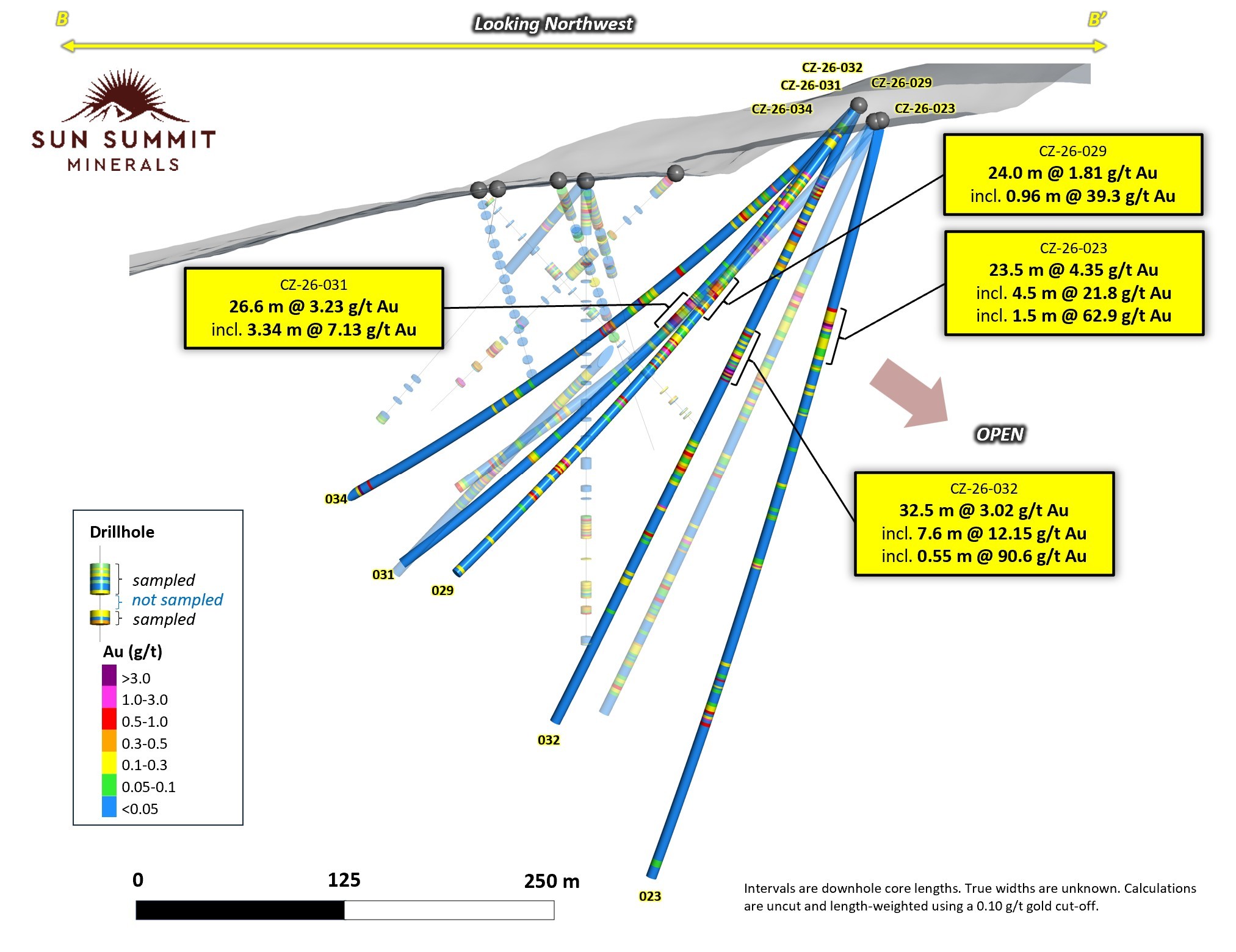
Figure 3. Oblique cross section through drill holes CZ-26-023, CZ-26-029, CZ-26-031, CZ-26-032 and CZ-26-034 showing downhole assay data.
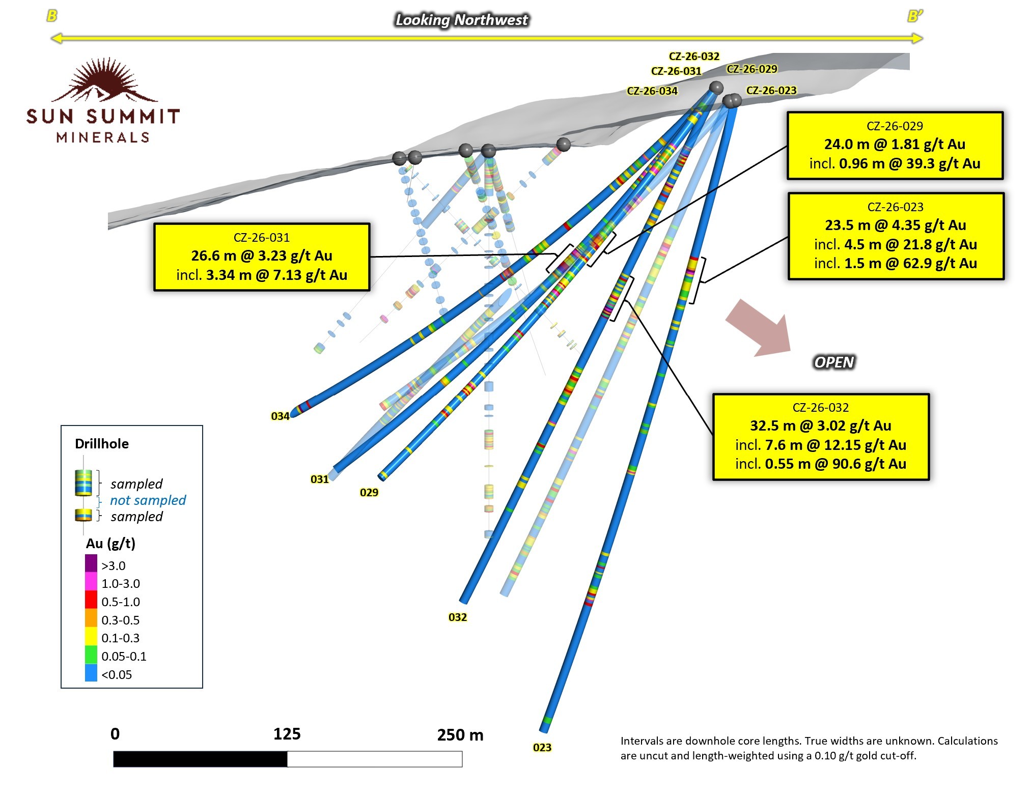
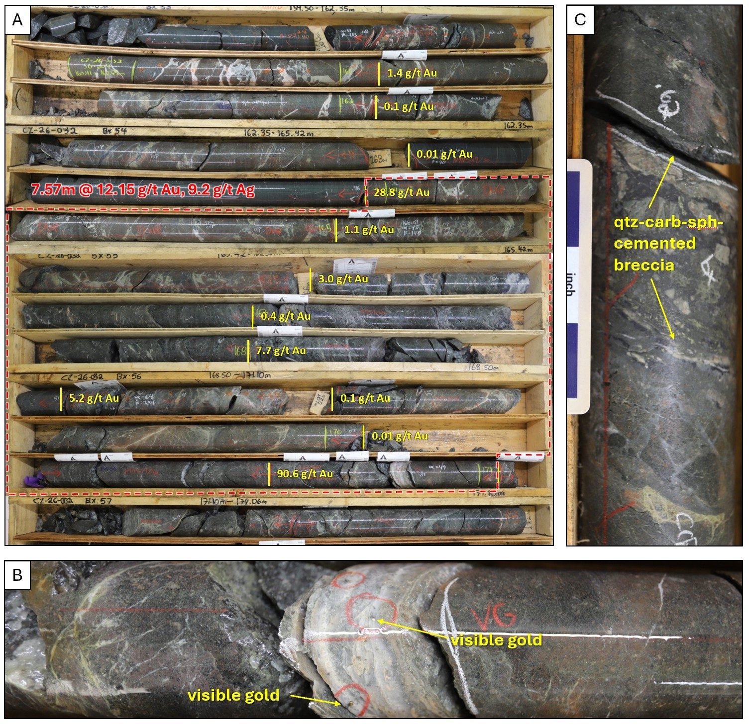
Figure 4. Core photos of CZ-26-032. Box photos showing core from 159.5 to 171.1 meters downhole which includes a strong interval of 7.57 meters of 12.15 g/t gold with 9.2 g/t silver. Individual down hole gold assays are annotated at sample depths, B. Quartz-carbonate vein at 170.83 meters with flecks of visible gold haloed by potassic alteration, C. Hydrothermal breccia at 168.7 meters with fine black sulphides and chalcopyrite. Abbreviations, qtz = quartz, carb = carbonate, sph = sphalerite
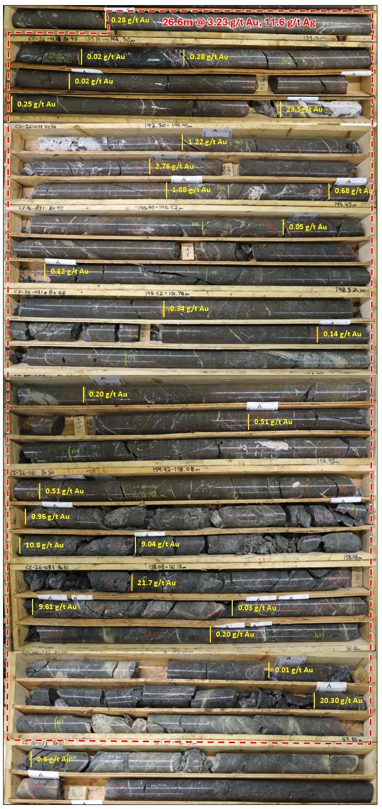
Figure 5. Core photos of CZ-26-031. Box photos showing core from 138.0 to 166.0 meters downhole which includes a broad interval of 26.6 meters of 3.23 g/t gold with 11.6 g/t silver. Individual down hole gold assays are annotated at sample depths.
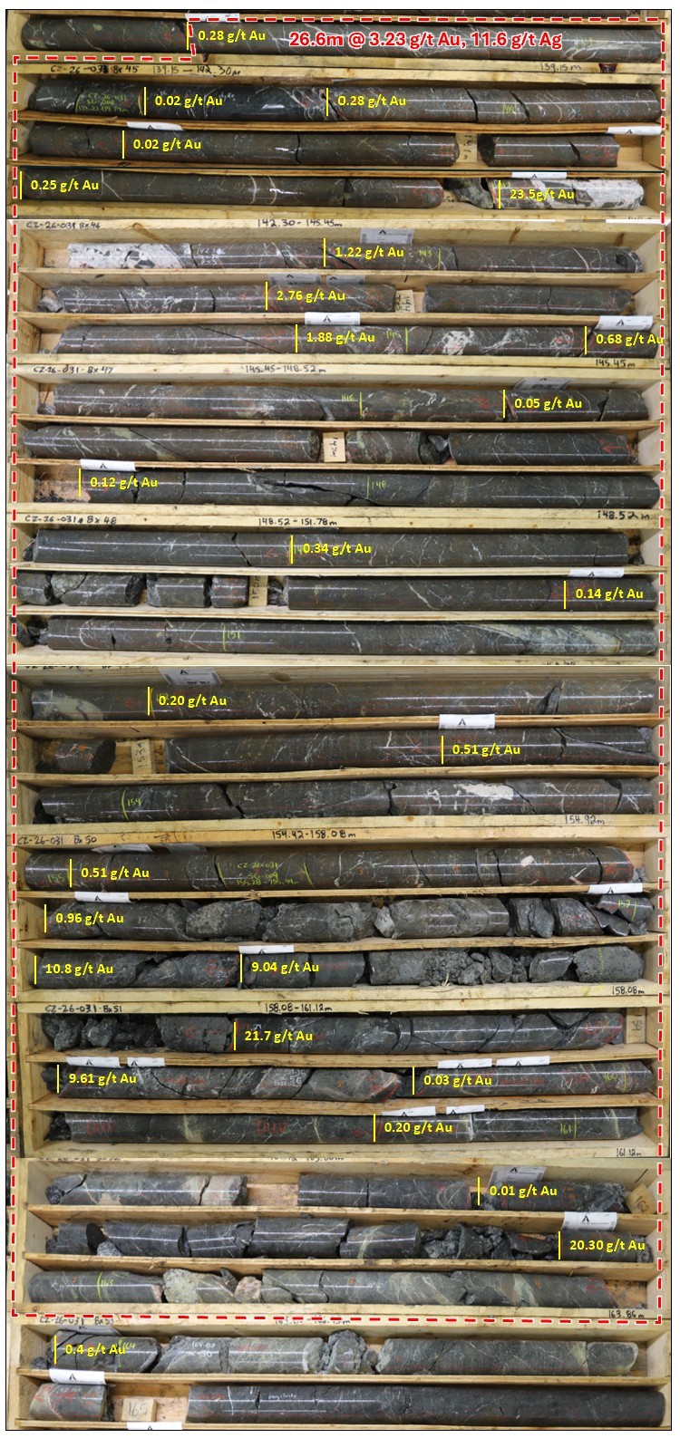
Table 1. Select Intervals for Drill Holes CZ-26-022 to CZ-26-034
| Hole ID | From (m) | To (m) | Interval (m) | Au (g/t) | Ag (g/t) |
| CZ-26-022 | 100.0 | 127.0 | 27.0 | 0.40 | 3.1 |
| including | 100.0 | 108.0 | 8.0 | 0.90 | 8.1 |
| and | 157.0 | 174.0 | 17.0 | 0.41 | 2.9 |
| including | 163.0 | 164.1 | 1.1 | 3.52 | 20.2 |
| and | 208.2 | 226.5 | 18.4 | 0.31 | 1.5 |
| including | 208.2 | 214.8 | 6.7 | 0.60 | 3.7 |
| and | 209.7 | 210.5 | 0.8 | 3.48 | 26.9 |
| CZ-26-023 | 109.0 | 132.5 | 23.5 | 4.35 | 4.7 |
| including | 116.5 | 121.0 | 4.5 | 21.80 | 20.2 |
| including | 118.0 | 119.5 | 1.5 | 62.90 | 46.6 |
| CZ-26-024 | 107.0 | 128.0 | 21.0 | 0.46 | 1.0 |
| and | 167.5 | 176.5 | 9.0 | 0.47 | 1.9 |
| and | 208.0 | 217.5 | 9.5 | 0.20 | 1.2 |
| and | 223.0 | 226.5 | 3.5 | 0.67 | 5.9 |
| CZ-26-025 | 100.9 | 138.0 | 37.1 | 0.57 | 1.4 |
| including | 100.9 | 122.0 | 21.1 | 0.82 | 1.7 |
| including | 100.9 | 105.0 | 4.1 | 1.16 | 1.3 |
| including | 121.5 | 122.0 | 0.5 | 13.25 | 40.9 |
| and | 169.0 | 181.6 | 12.6 | 0.25 | 0.9 |
| CZ-26-026 | 109.4 | 126.0 | 16.6 | 0.75 | 1.3 |
| including | 110.8 | 111.7 | 0.9 | 9.19 | 6.9 |
| and | 309.2 | 322.5 | 13.4 | 0.53 | 0.3 |
| and | 396.5 | 403.8 | 7.3 | 0.90 | 1.6 |
| and | 402.8 | 403.8 | 1.0 | 4.42 | 0.6 |
| CZ-26-027 | 106.0 | 114.0 | 8.0 | 0.79 | 1.6 |
| and | 125.0 | 134.0 | 9.0 | 0.61 | 1.8 |
| and | 183.0 | 184.0 | 1.0 | 3.20 | 20.5 |
| CZ-26-028 | 110.1 | 132.2 | 22.1 | 0.57 | 2.8 |
| and | 176.0 | 190.5 | 14.5 | 1.47 | 9.1 |
| including | 176.0 | 184.2 | 8.2 | 2.50 | 15.4 |
| including | 176.0 | 180.5 | 4.5 | 4.21 | 25.4 |
| and | 236.0 | 241.3 | 5.3 | 0.37 | 0.5 |
| and | 353.6 | 356.5 | 2.9 | 0.65 | 2.4 |
| CZ-26-029 | 20.0 | 29.5 | 9.5 | 0.27 | 3.0 |
| including | 21.4 | 21.9 | 0.6 | 2.43 | 21.4 |
| and | 49.0 | 74.0 | 25.0 | 0.42 | 1.3 |
| and | 126.0 | 150.0 | 24.0 | 1.81 | 2.6 |
| including | 136.3 | 137.3 | 1.0 | 39.30 | 52.2 |
| and | 167.0 | 190.0 | 23.0 | 0.45 | 0.3 |
| including | 177.0 | 180.0 | 3.0 | 1.59 | 0.7 |
| and | 214.5 | 219.0 | 4.5 | 0.73 | 0.3 |
| and | 262.6 | 278.0 | 15.4 | 0.30 | 0.9 |
| and | 286.0 | 293.3 | 7.3 | 0.25 | 0.1 |
| CZ-26-030 | 126.0 | 164.0 | 38.0 | 0.41 | 0.8 |
| and | 205.0 | 210.5 | 5.5 | 0.41 | 0.5 |
| and | 234.0 | 247.0 | 13.0 | 0.14 | 0.8 |
| and | 259.0 | 270.5 | 11.5 | 0.26 | 0.4 |
| CZ-26-031 | 57.4 | 87.2 | 29.8 | 0.35 | 0.6 |
| including | 73.1 | 76.1 | 3.0 | 1.27 | 1.4 |
| and | 138.3 | 164.9 | 26.6 | 3.23 | 11.6 |
| including | 141.2 | 164.9 | 23.7 | 3.60 | 13.0 |
| including | 142.0 | 142.8 | 0.8 | 23.50 | 173.00 |
| including | 142.0 | 145.3 | 3.3 | 7.13 | 42.3 |
| including | 156.0 | 159.6 | 3.6 | 9.72 | 39.0 |
| including | 162.8 | 164.9 | 2.2 | 10.58 | 6.5 |
| CZ-26-032 | 43.2 | 107.0 | 63.8 | 0.48 | 2.1 |
| including | 48.5 | 80.5 | 32.0 | 0.81 | 3.6 |
| including | 48.5 | 55.5 | 7.0 | 1.60 | 13.5 |
| including | 70.5 | 80.5 | 10.0 | 1.33 | 1.6 |
| and | 139.0 | 171.5 | 32.5 | 3.02 | 2.5 |
| including | 163.9 | 171.5 | 7.6 | 12.15 | 9.2 |
| including | 170.5 | 171.1 | 0.6 | 90.60 | 15.5 |
| and | 210.2 | 231.0 | 20.8 | 0.27 | 0.2 |
| and | 250.3 | 253.0 | 2.7 | 0.47 | 0.0 |
| CZ-26-033 | 119.0 | 128.5 | 9.5 | 0.30 | 0.7 |
| and | 134.5 | 137.0 | 2.5 | 0.11 | 0.4 |
| and | 143.0 | 145.0 | 2.0 | 0.60 | 0.6 |
| and | 149.5 | 172.5 | 23.0 | 0.41 | 1.1 |
| and | 212.5 | 216.8 | 4.3 | 1.15 | 1.5 |
| CZ-26-034 | 49.2 | 52.4 | 3.2 | 0.20 | 10.7 |
| and | 65.6 | 67.5 | 1.9 | 0.86 | 1.2 |
| and | 136.0 | 138.7 | 2.7 | 0.91 | 14.5 |
| and | 163.5 | 166.3 | 2.8 | 1.86 | 0.9 |
| and | 185.0 | 193.8 | 8.8 | 2.20 | 2.4 |
| including | 186.2 | 190.3 | 4.2 | 4.31 | 3.3 |
| and | 357.0 | 360.0 | 3.0 | 2.19 | 0.9 |
Notes:
- Intervals are downhole core lengths. True widths are unknown.
- Calculations are uncut and length-weighted using a 0.10 g/t gold cut-off with maximum of 3.0 meter internal dilution.
- Grades have not been capped in the length-weighted averaging.
Table 2. Drill Collar Information
| Hole ID | Zone | Easting | Northing | Elevation (m) | Azimuth | Dip | Depth (m) |
| CZ-26-022 | creek | 608271 | 6368488 | 1508 | 202 | -75 | 389.0 |
| CZ-26-023 | creek | 608271 | 6368489 | 1508 | 243 | -75 | 449.0 |
| CZ-26-024 | creek | 608422 | 6368372 | 1556 | 238 | -60 | 363.1 |
| CZ-26-025 | creek | 608422 | 6368372 | 1556 | 214 | -59 | 340.0 |
| CZ-26-026 | creek | 608366 | 6368442 | 1538 | 239 | -63 | 419.0 |
| CZ-26-027 | creek | 608422 | 6368372 | 1556 | 225 | -70 | 399.0 |
| CZ-26-028 | creek | 608367 | 6368442 | 1538 | 218 | -70 | 401.0 |
| CZ-26-029 | creek | 608220 | 6368556 | 1501 | 210 | -45 | 354.0 |
| CZ-26-030 | creek | 608509 | 6368319 | 1583 | 202 | -53 | 401.0 |
| CZ-26-031 | creek | 608219 | 6368556 | 1501 | 230 | -50 | 360.0 |
| CZ-26-032 | creek | 608220 | 6368557 | 1501 | 240 | -65 | 388.0 |
| CZ-26-033 | creek | 608509 | 6368320 | 1583 | 223 | -63 | 358.0 |
| CZ-26-034 | creek | 608219 | 6368556 | 1501 | 247 | -47 | 396.0 |
Notes:
- Coordinates are given in UTM Nad83 Zone 9N.
- Elevations are in meters above sea level
- Inclination expressed as negative angles below horizontal
- Drill collar survey by RTK (Real-Time Kinematic) GPS/GNSS method
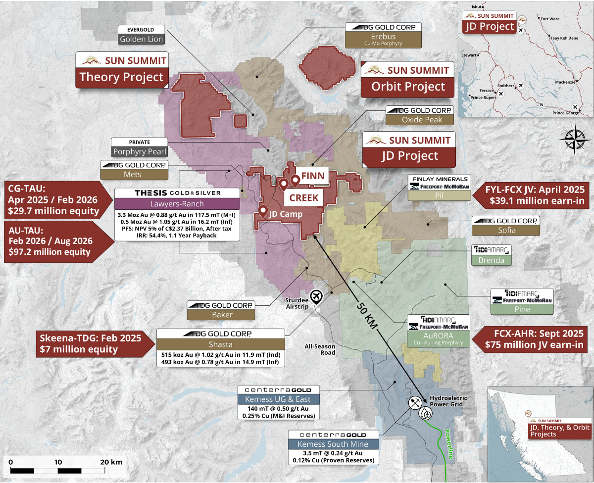
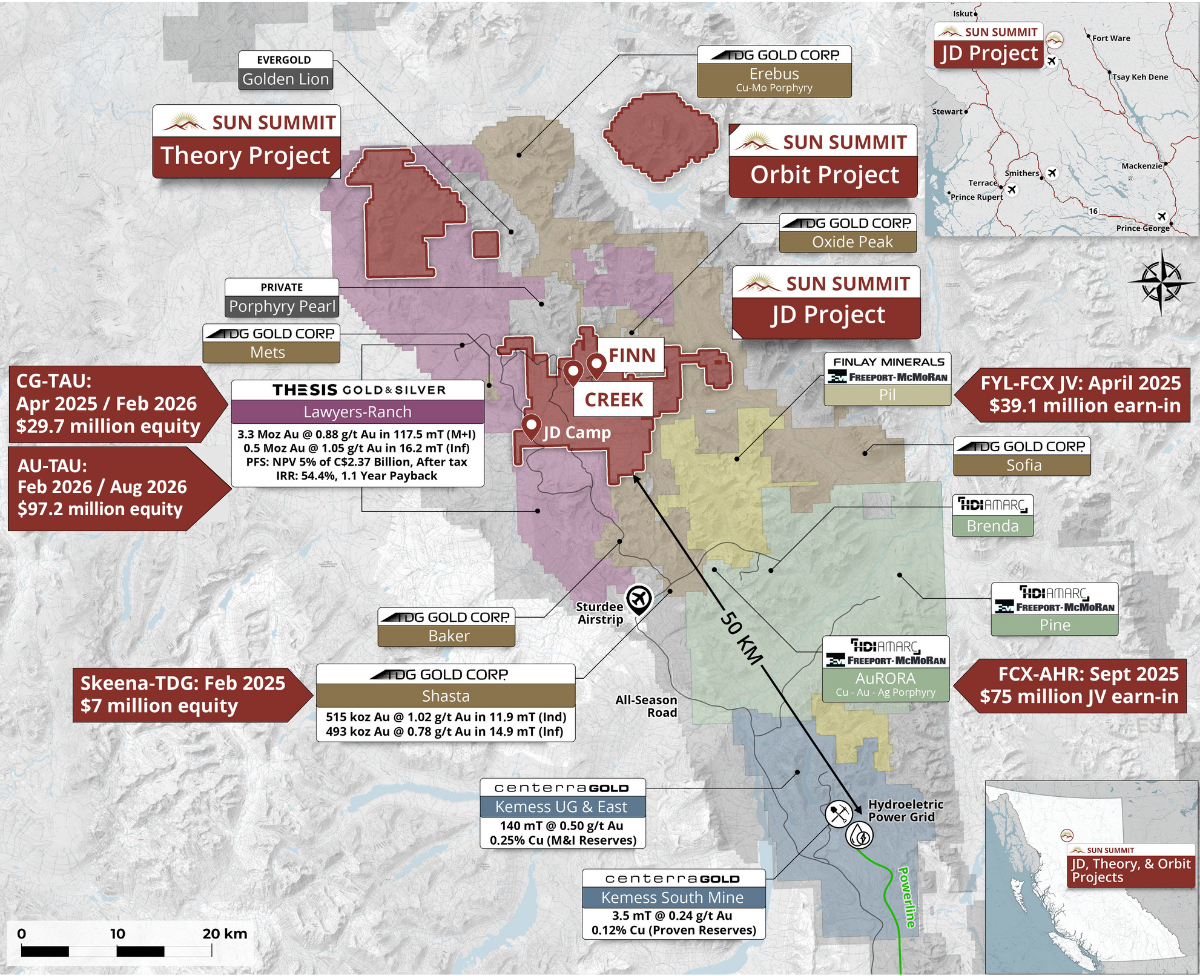
Figure 6. Map of the Toodoggone District showing the location of the JD Project in relation to other development and exploration projects. Data sourced from Thesis Gold Inc., TDG Gold Corp. and Centerra Gold Inc.’s respective corporate websites. The QP has been unable to verify the information and the information is not necessarily indicative to the mineralization on the property that is the subject of the disclosure.
Quality Assurance and Quality Control
All drill core sample assay and analytical results have been monitored through the Company’s quality assurance and quality control program (QA/QC) which includes core sampling protocols. Sample collection in mineralized core consists of a minimum 0.3 m interval to a maximum of 1.0 m interval. The maximum sample length in less mineralized or weakly altered core is 2.0 meters. The drill core sample is cut in half with a diamond saw, with half of the core placed in individual sealed polyurethane bags and the remaining half securely retained in the original core box for permanent storage at Sun Summit’s dedicated and secure core logging and processing facility at the JD exploration camp.
The sampled drill core was shipped by a bonded courier in sealed and secured woven polyester bags to the ALS Global preparation facilities in Kamloops, BC. Core samples were prepared using ALS standard preparation procedure PREP-31A which involves crushing the sample to 70% less than 2mm, followed by a riffle split of 250g, and then a pulverised split to better than 85% passing 75 microns.
Following sample preparation, the pulps were sent to the ALS Global analytical laboratory in North Vancouver, B.C. for analysis. ALS Global is registered to ISO/IEC 17025:2017 accreditations for laboratory procedures.
Drill core samples were analyzed for 48 elements by ICP-MS on a 0.25-gram aliquot using a four-acid digestion (method ME-MS61). This method is considered a “ultra trace element” analytical method with low detection limits on key pathfinder elements such as Ag, As, Sb, Se and Tl.
Gold was analyzed by fire assay on a 50-gram aliquot with an AES finish (inductively coupled plasma atomic emission spectroscopy – method Au-ICP22). Samples that returned >10 parts per million (ppm) gold were re-analyzed by fire assay using a gravimetric finish on a 50-gram aliquot (method Au-GRA22).
Overlimit samples (e.g. Ag, Cu, Pb & Zn) were re-analyzed using an ore-grade, four-acid digestion and ICP-AES finish (method ME-OG62). Over limits for key elements: samples with >100 ppm silver, >10,000 ppm Cu, >10,000 ppm Pb and >10,000 ppm Zn.
Specific gravity measurements were done in the core shack at time of logging using the water immersion method (i.e. “wet-dry” method). Approximately 10% of random samples were also selected for specific gravity measurement at the ALS Lab using their OA-GRA08b method (without wax coating).
In addition to ALS Global laboratory QA/QC protocols, Sun Summit implements a rigorous internal QA/QC program that includes the insertion of duplicates, certified reference materials (standards prepared by an independent lab) and blanks into the sample stream.
A total of 3,495 samples were taken in the field from the holes disclosed in this release, including 379 QA/QC samples, representing 10.8% of the sample stream. Of the 379 samples, 147 samples were CRM samples representing 5 different grade profiles for gold, silver and copper; the remainder were either coarse field blanks or CRM blanks. There were no significant issues identified in either the internal or external QA/QC samples.
National Instrument 43-101 Disclosure
This news release has been reviewed and approved by Sun Summit’s Vice President Exploration, Ken MacDonald, P. Geo., a “Qualified Person” as defined in National Instrument 43-101 Standards of Disclosure for Mineral Projects of the Canadian Securities Administrators. Mr. MacDonald has verified the data disclosed in this press release, including the sampling, analytical and test data underlying this information that has been collected by Sun Summit. Verification procedures include industry standard quality control practices. Some technical information contained in this news release is historical in nature and has been compiled from public sources believed to be accurate. The historical technical information has not been verified by Sun Summit and may in some instances be unverifiable dependent on the existence of historical drill core and grab samples.
Community Engagement
Sun Summit is engaging with First Nations on whose territory our projects are located and is discussing their interests and identifying contract and work opportunities, as well as opportunities to support community initiatives. The Company looks forward to continuing to work with local and regional First Nations with ongoing exploration.
About the JD Project
The JD Project is located in the Toodoggone mining district in north-central British Columbia, a highly prospective deposit-rich mineral trend. The JD Project covers an area of over 15,000 hectares and is in close proximity to active exploration and development projects, such as Thesis Gold and Silver Inc.’s Lawyers and Ranch projects, TDG Gold Corp’s Baker-Shasta projects, Amarc Resource Ltd.’s AuRORA project, Centerra’s Gold Inc’s Kemess East and Underground projects, as well as the past-producing Kemess open pit copper-gold mine.
The project is 450 kilometers northwest of the city of Prince George, and 25 kilometers north of the Sturdee airstrip. It is proximal to existing infrastructure in place to support the past-producing Kemess mine, including roads and a hydroelectric power line.
The JD Project is in a favourable geological environment characterized by both high-grade epithermal gold and silver mineralization, as well as porphyry-related copper and gold mineralization. Some historical exploration, including drilling, geochemistry and geophysics, has been carried out on the property, however the project area is largely underexplored.
About Sun Summit
Sun Summit Minerals (TSXV: SMN) (OTCQB: SMREF) is a mineral exploration company focused on the discovery, expansion, and advancement of district-scale gold and copper assets in British Columbia. The Company’s portfolio is anchored by its flagship JD Project, alongside the Theory Project in the prolific Toodoggone region of north-central BC, and the Buck Project in central B.C.
Further details are available at www.sunsummitminerals.com.
References
- Hawkins, P.A. (1998), 1997 Exploration Report on the Creek Zone for Antares Mining and Exploration Corporation and AGC Americas Gold Corporation, JD Property, Toodoggone River Area, Omineca Mining Division, Internal Report #98-065-1.
- Davis, J.W., and Jamieson, M.D. (1998), Drilling and Geophysical Report on the M.H. Mineral Clain Group, Toodoggone District, Assessment Report Indexing System, Report 25757, https://apps.nrs.gov.bc.ca/pub/aris.
- Krause, R.G. (1995), 1994 Geological and Geochemical Report on the JD Gold Silver Property, Toodoggone River Area, Omineca Mining Division, British Columbia, Assessment Report Indexing System, Report 23663, https://apps.nrs.gov.bc.ca/pub/aris.
- Krause, R.G. (1996), 1995 Geological Report on the JD Gold Silver Property, Toodoggone River Area, Omineca Mining Division, British Columbia, Assessment Report Indexing System, Report 24284, https://apps.nrs.gov.bc.ca/pub/aris.
- McBride, S. (2013), 2012 Geological, geochemical and diamond drilling report on the JD Property, Assessment Report Indexing System, Report 33556, https://apps.nrs.gov.bc.ca/pub/aris.
- McBride, S. and Leslie, C. (2014), 2013 Geological, geophysical and diamond drilling report on the JD Property, Assessment Report Indexing System, Report 34762, https://apps.nrs.gov.bc.ca/pub/aris.
On behalf of the board of directors
Niel Marotta
Chief Executive Officer & Director
[email protected]
For further information, contact:
Matthew Benedetto, Simone Capital
[email protected]
Tel. 416-817-1226
Forward-Looking Information
Statements contained in this news release that are not historical facts may be forward-looking statements, which involve risks, uncertainties and other factors that could cause actual results to differ materially from those expressed or implied by such forward-looking statements. In addition, the forward-looking statements require management to make assumptions and are subject to inherent risks and uncertainties. There is significant risk that the forward-looking statements will not prove to be accurate, that the management’s assumptions may not be correct and that actual results may differ materially from such forward-looking statements. Accordingly, readers should not place undue reliance on the forward-looking statements. Generally forward-looking statements can be identified by the use of terminology such as “anticipate”, “will”, “expect”, “may”, “continue”, “could”, “estimate”, “forecast”, “plan”, “potential” and similar expressions. Forward-looking statements contained in this press release may include, but are not limited to, the anticipated timing of the Creek Zone, Finn Zone and Schmitt Zone assays and the Company’s intention to provide further updated regarding the same; the Company’s expectation that results from the 2026 drill program will contribute to an inaugural mineral resource estimate and the timing of any such estimate; the advancement of exploration targets at the JD Project; and the Company’s exploration plans, expectations and forecasts. These forward-looking statements are based on a number of assumptions which may prove to be incorrect which, without limiting the generality of the following, include: the Company’s ability to complete the drill program as currently contemplated; receipt of the remaining holes’ assays’ completion of domain modelling; risks inherent in exploration activities; volatility and sensitivity to market prices; volatility and sensitivity to capital market fluctuations; and fluctuations in metal prices. The forward-looking statements contained in this news release are made as of the date hereof or the dates specifically referenced in this press release, where applicable. Except as required by applicable securities laws and regulation, Sun Summit disclaims any intention or obligation to update or revise any forward-looking statement, whether as a result of new information, future events or otherwise, except as required by applicable securities laws. All forward-looking statements contained in this press release are expressly qualified by this cautionary statement.
Neither the TSX Venture Exchange nor its Regulation Services Provider (as that term is defined in the policies of the TSX Venture Exchange) accepts responsibility for the adequacy or accuracy of this release.
Resource World Magazine Inc. has prepared this editorial for general information purposes only and should not be considered a solicitation to buy or sell securities in the companies discussed herein. The information provided has been derived from sources believed to be reliable but cannot be guaranteed. This editorial does not take into account the readers investment criteria, investment expertise, financial condition, or financial goals of individual recipients and other concerns such as jurisdictional and/or legal restrictions that may exist for certain persons. Recipients should rely on their own due diligence and seek their own professional advice before investing.