Maiden Drill Program Underway at Goliath’s Treasure Island, Hosting Multiple Outcropping VMS Type Shear-Hosted Polymetallic Zones, Channels up to 20.60 g/t Gold Over 0.85 Meters and up to 14.45% Copper in Samples, Golden Triangle, B.C.
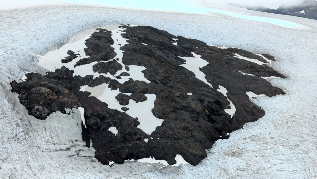
NEWLY DISCOVERED TREASURE ISLAND 550 x 450 Meters – HIGHLIGHTS OF DRILL TARGET:
- The planned 2024 program at Treasure Island includes 11 holes from 4 drill pad locations with one diamond drill rig for 1,600 meters; additional drill holes will be designed based on mineralized intercepts.
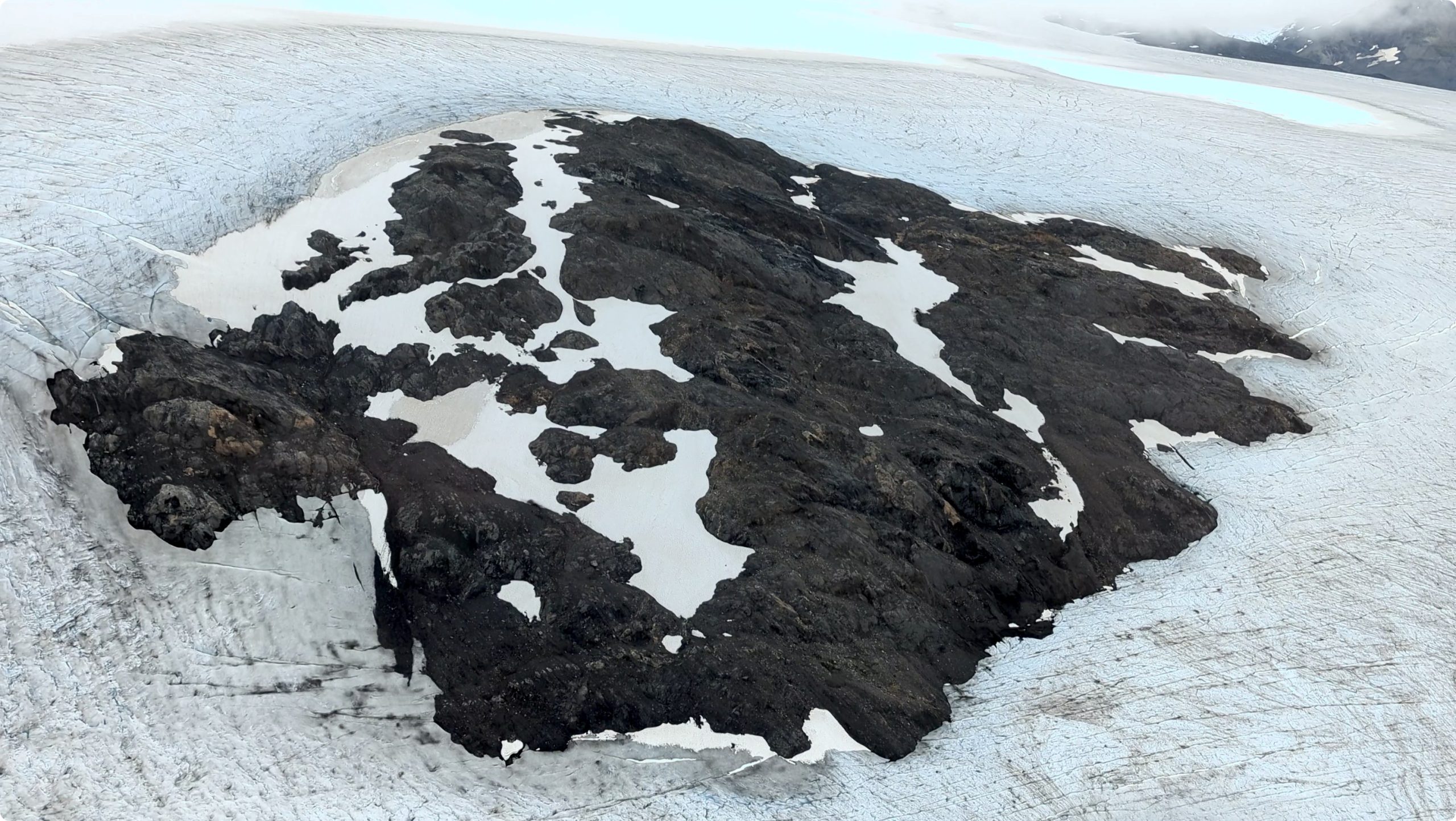
- Treasure Island is located on Golddiggers Cambria Icefields claim blocks, 36 km north of the Surebet discovery, and only has recently been exposed due to the result of glacial retreat and permanent snowpack abatement (see map below).
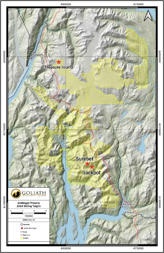
- Its located 6 km east of, and on trend with, the Porter Idaho mine classified as a polymetallic vein deposit and/or possible VMS deposit that was operational in the early 1900’s. (see map below).
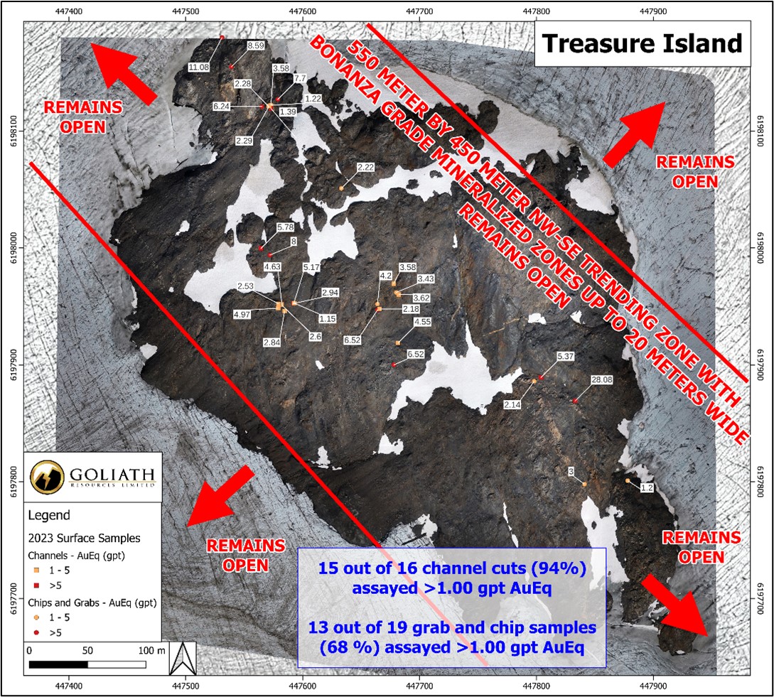
- The new Treasure Island discovery consists of multiple shear-hosted, polymetallic zones covering an area of approximately 550 by 450 meters and is NW-SE trending. The extent of mineralization is currently open in all directions.
- Broad high-grade mineralized zones are up to 20 meters wide with sections of massive chalcopyrite and pyrite occupying shears and forming sulphide-rich mineralization at structural intersections and embayment zones within strongly folded and sheared mudstone, siltstone, and tuff units.
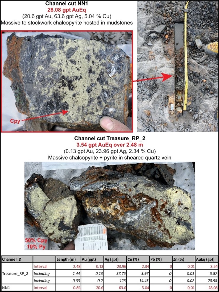
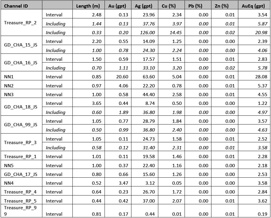
- Channel samples collected assayed up to 20.60 over 0.85 meters or 28.08 gpt AuEq (20.60 gpt Au, 63.60 gpt Ag and 5.04 % Cu) (see images below).
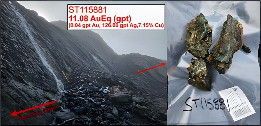
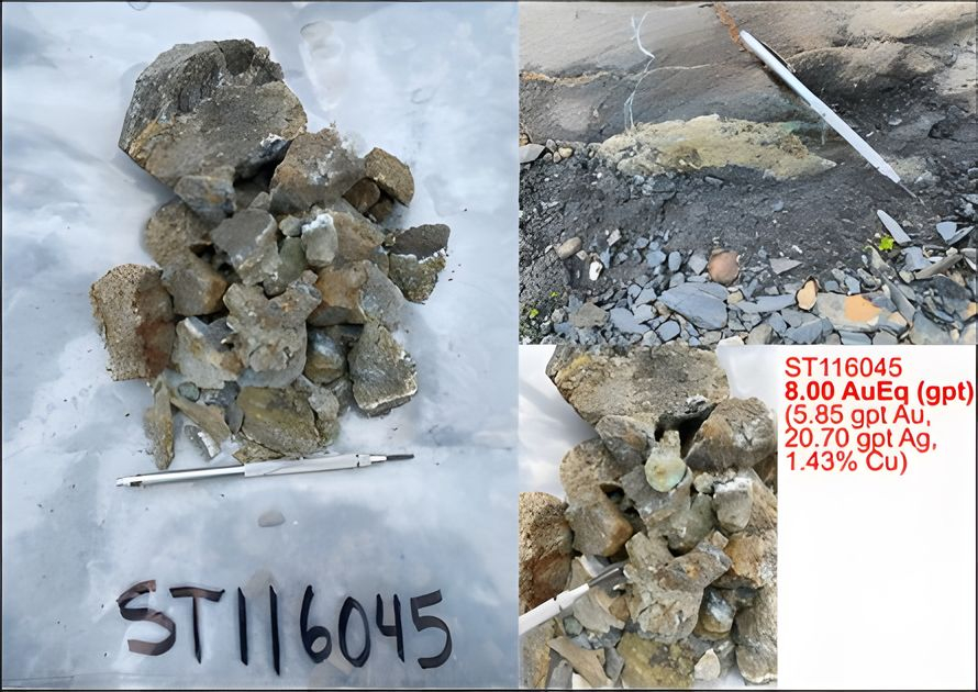
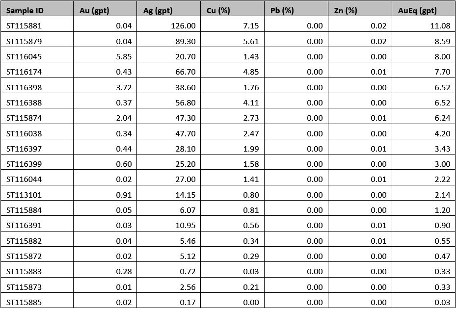
- Widespread grab and chip samples assayed up to 11.08 gpt AuEq (0.04 gpt Au, 126.00 gpt Ag and 7.15 % Cu); and 8.00 gpt AuEq (5.85gpt Au, 20.70 gpt Ag and 1.43 % Cu) (see images below).
- A noteworthy 13 out of 19 grab and chip samples (68%) taken on Treasure Island over a wide area assayed >1.00 gpt AuEq.
- An exceptional 15 out of 16 channel cuts (94%) assayed >1.00 gpt AuEq.
- The new Treasure Island target demonstrates the excellent untapped potential for additional discoveries across the large Golddigger property, which encompasses 56 km of the “Red Line”, which is the name we use to describe a key geological contact between two regional stratigraphic packages (read more below – About Golddigger Property).
- In the Golden Triangle the most important discoveries and mines are on either side of “Red Line” and within a 3 kilometers meters of either side. We consider this a critical exploration vector and the Golddigger project is within the sweet spot of the “Red Line.”
Goliath Resources Limited (TSX-V: GOT) (OTCQB: GOTRF) (FSE: B4IF) (the “Company” or “Goliath”) is pleased to report the maiden diamond drill program is underway at its newly discovered high-grade gold-copper Treasure Island outcropping mineralized target which remains open. Its located on the Cambria Icefields at its 100% controlled Golddigger Property (the “Property”), Golden Triangle, British Columbia.
Roger Rosmus, Founder and CEO of Goliath Resources, states: “We have been looking forward to drilling Treasure Island from the first time we saw this widespread outcropping target when flying over it in the helicopter. Once again, the team has done an excellent job finding this new highly mineralized drill target with massive sulphides in a vast sea of white and ground truthing it in preparation for its first ever drill program in 2024. The surface assay results, geology, geochemistry and its close proximity to the past producing Porter Idaho mine suggests it has all the makings of a VMS Eskay Creek type material discovery unlocking additional value to our shareholders. We look forward to announcing the assay results once received, complied and interpreted.”
The Treasure Island outcropping mineralized target is 36 km north of the Surebet discovery, 6 km to the east of, and on trend with, the Porter Idaho mine and 9 km east of Stewart, British Columbia. The target has recently been exposed as a result of glacial abatement and will be drill tested for the first time during the 2024 field season.
A total 15 out of 16 channel cuts assayed > 1.00 gpt AuEq, which corresponds to 94 % of channel cuts collected on Treasure Island to date. In addition, 13 out of 19 grab and chip samples assayed > 1.00 gpt AuEq, which corresponds to 68 % of chip and grab samples collected on Treasure Island to date. Channel samples collected on Treasure Island assayed up to 28.08 gpt AuEq (20.60 gpt Au, 63.60 gpt Ag and 5.04 % Cu) over 0.85 meters; and 3.54 gpt AuEq (0.13 gpt Au, 23.96 gpt Ag and 2.34 % Cu). Grab and chip samples collected on Treasure Island assayed up to 11.08 gpt AuEq (0.04 gpt Au, 126.00 gpt Ag and 7.15 % Cu); and 8.00 gpt AuEq (5.85gpt Au, 20.70 gpt Ag and 1.43 % Cu). See Table 1 and 2 below for complete assay results.
The new high-grade gold-copper Treasure Island target consists of new mineralized bedrock outcrops that have been exposed by glacial melt. This newly discovered mineralized area shows multiple shear-hosted, polymetallic zones over a 550 meter by 450 meter NW-SE trending area that remains open in all directions. Mineralized domains are up to 20 meters wide with sections of massive chalcopyrite and pyrite occupying shears and forming sulphide-rich mineralization at structural intersections and embayment zones within strongly folded and sheared mudstone, siltstone, and tuff units.
The Full Contact showing also located on the Cambria Icefields has been shelved for this year and no drilling is planned in 2024.
Table 1: 2023 grab and chip samples from Treasure Island.
Table 2: 2023 channel samples from Treasure Island.
Golddigger Property
The Golddigger Property is 100% controlled covering an area of 66,608 hectares (164,592 acres) and is in the world class geological setting of the Eskay Rift and within 3 km of the Red Line in the Golden Triangle of British Columbia. This area and proximity have hosted some of Canada’s greatest mines that include Eskay Creek, Premier and Snip. Other significant and well known deposits in the Golden Triangle include Brucejack, Copper Canyon, Galore Creek, Granduc, KSM, Red Chris, and Schaft Creek. Goliath controls 56 kilometers of the Red Line which is a geologic contact between Triassic age Stuhini rocks and Jurassic age Hazelton rocks that is used as a key marker when exploring for gold-copper-silver mineralization.
The Surebet discovery has exceptional continuity and excellent metallurgy with gold recoveries of 92.2% inclusive of 48.8% free gold from gravity alone at a 327-micrometer crush (no deleterious elements and no cyanide required to recover the gold based on metallurgical work completed to date).
It is in an excellent location in close proximity to the communities of Alice Arm and Kitsault where there is a permitted mill site on private property. It is situated on tide water with direct barge access to Prince Rupert (190 kilometers via the Observatory inlet/Portland inlet). The town of Kitsault is accessible by road (190 kilometers from Terrace, 300 kilometers from Prince Rupert) and has a barge landing, dock, and infrastructure capable of housing at least 300 people, including high-tension power.
Additional infrastructure in the area includes the Dolly Varden Silver Mine Road (only 7 kilometers to the East of the Surebet discovery) with direct road access to Alice Arm barge landing (18 kilometers to the south of the Surebet discovery) and high-tension power (25 kilometers to the East of Surebet discovery). The city of Terrace (population 16,000) provides access to railway, major highways, and airport with supplies (food, fuel, lumber, etc.), while the town of Prince Rupert (population 12,000) is located on the west coast and houses an international container seaport also with direct access to railway and an airport with supplies.
About CASERM (Center To Advance The Science Of Exploration To Reclamation In Mining)
Goliath is a paying member and active supporter of CASERM which is an organization represents a collaborative venture between Colorado School of Mines and Virginia Tech aimed at transforming the way that geoscience data are used in the mineral resource industry. Research focuses on the integration of diverse geoscience data to improve decision making across the mine life cycle, beginning with the exploration for subsurface earth resources continuing through mine operation as well as closure and environmental remediation. As a CASERM member, the Company requested a study and written report to be performed by Colorado School of Mines analysing Surebet’s origin of mineralization that confirmed in its report, an extensive porphyry feeder source at depth for the high-grade gold mineralising fluids at Surebet.
Qualified Person
Rein Turna P. Geo is the qualified person as defined by National Instrument 43-101, for Goliath Resource Limited projects, and supervised the preparation of, and has reviewed and approved, the technical information in this release. Mr. Turna is also a director of the Company.
About Goliath Resources Limited
Goliath Resources Limited is an explorer of precious metals projects in the prolific Golden Triangle of northwestern British Columbia and Abitibi Greenstone Belt of Quebec. All of its projects are in world class geological settings and geopolitical safe jurisdictions amenable to mining in Canada. Goliath is a member and active supporter of CASERM which is an organization represents a collaborative venture between Colorado School of Mines and Virginia Tech. Goliath’s key strategic cornerstone shareholders include Crescat Capital, Mr. Rob McEwen and Mr. Eric Sprott.
For more information please contact:
Goliath Resources Limited
Mr. Roger Rosmus
Founder and CEO
Tel: +1.416.488.2887
Other
The reader is cautioned that grab samples are spot samples which are typically, but not exclusively, constrained to mineralization. Grab samples are selective in nature and collected to determine the presence or absence of mineralization and are not intended to be representative of the material sampled.
Portable XRF (X-Ray Fluorescence) readings are semi-quantitative measurements and calibrations of the equipment in the field not always allow to compare results to certified reference materials but are used as guideline to augment the understanding of the mineralization observed. These measurements are not intended to be representative of the geochemical composition of the material measured. XRF readings are carried out using a handheld device and could be influenced by external factors.
Oriented HQ-diameter or NQ-diameter diamond drill core from the drill campaign is placed in core boxes by the drill crew contracted by the Company. Core boxes are transported by helicopter to the staging area, and then transported by truck to the core shack. The core is then re-orientated, meterage blocks are checked, meter marks are labelled, Recovery and RQD measurements taken, and primary bedding and secondary structural features including veins, dykes, cleavage, and shears are noted and measured. The core is then described and transcribed in MX DepositTM. Drill holes were planned using Leapfrog GeoTM and QGISTM software and data from the 2017-2022 exploration campaigns. Drill core containing quartz breccia, stockwork, veining and/or sulphide(s), or notable alteration are sampled in lengths of 0.5 to 1.5 meters. Core samples are cut lengthwise in half, one-half remains in the box and the other half is inserted in a clean plastic bag with a sample tag. Standards, blanks and duplicates were added in the sample stream at a rate of 10%.
Grab, channels, chip and talus samples were collected by foot with helicopter assistance. Prospective areas included, but were not limited to, proximity to MINFile locations, placer creek occurrences, regional soil anomalies, and potential gossans based on high-resolution satellite imagery. The rock grab and chip samples were extracted using a rock hammer, or hammer and chisel to expose fresh surfaces and to liberate a sample of anywhere between 0.5 to 5.0 kilograms. All sample sites were flagged with biodegradable flagging tape and marked with the sample number. All sample sites were recorded using hand-held GPS units (accuracy 3-10 meters) and sample ID, easting, northing, elevation, type of sample (outcrop, subcrop, float, talus, chip, grab, etc.) and a description of the rock were recorded on all-weather paper. Samples were then inserted in a clean plastic bag with a sample tag for transport and shipping to the geochemistry lab. QA/QC samples including blanks, standards, and duplicate samples were inserted regularly into the sample sequence at a rate of 10%.
All samples are transported in rice bags sealed with numbered security tags. A transport company takes them from the core shack to the ALS labs facilities in North Vancouver. ALS is either certified to ISO 9001:2008 or accredited to ISO 17025:2005 in all of its locations. At ALS samples were processed, dried, crushed, and pulverized before analysis using the ME-MS61 and Au-SCR21 methods. For the ME-MS61 method, a prepared sample is digested with perchloric, nitric, hydrofluoric, and hydrochloric acids. The residue is topped up with dilute hydrochloric acid and analyzed by inductively coupled plasma atomic emission spectrometry. Overlimits were re-analyzed using the ME-OG62 and Ag-GRA21 methods (gravimetric finish). For Au-SCR21 a large volume of sample is needed (typically 1-3kg). The sample is crushed and screened (usually to -106 micron) to separate coarse gold particles from fine material. After screening, two aliquots of the fine fraction are analysed using the traditional fire assay method. The fine fraction is expected to be reasonably homogenous and well represented by the duplicate analyses. The entire coarse fraction is assayed to determine the contribution of the coarse gold.
Widths are reported in drill core lengths and the true widths are estimated to be 80-90% and AuEq metal values are calculated using: AuEq metal values are calculated using: Au 1924.79 USD/oz, Ag 22.76 USD/oz, Cu 3.75 USD/lbs, Pb 2128.75 USD/ton and Zn 2468.50 USD/ton on December 23, 2023. There is potential for economic recovery of gold, silver, copper, lead, and zinc from these occurrences based on other mining and exploration projects in the same Golden Triangle Mining Camp where Goliath’s project is located such as the Homestake Ridge Gold Project (Auryn Resources Technical Report, Updated Mineral Resource Estimate and Preliminary Economic Assessment on the Homestake Ridge Gold Project, prepared by Minefill Services Inc. Bothell, Washington, dated May 29, 2020). Here, AuEq values were calculated using 3-year running averages for metal price, and included provisions for metallurgical recoveries, treatment charges, refining costs, and transportation. Recoveries for Gold were 85.5%, Silver at 74.6%, Copper at 74.6% and Lead at 45.3%. It will be assumed that Zinc can be recovered with the Copper at the same recovery rate of 74.6%. The quoted reference of metallurgical recoveries is not from Goliath’s Golddigger Project, Surebet Zone mineralization, and there is no guarantee that such recoveries will ever be achieved, unless detailed metallurgical work such as in a Feasibility Study can be eventually completed on the Golddigger Project.
Neither the TSX Venture Exchange nor its Regulation Services Provider (as that term is defined in the policies of the TSX Venture Exchange), nor the OTCQB Venture Market accepts responsibility for the adequacy or accuracy of this release.
Certain statements contained in this press release constitute forward-looking information. These statements relate to future events or future performance. The use of any of the words “could”, “intend”, “expect”, “believe”, “will”, “projected”, “estimated” and similar expressions and statements relating to matters that are not historical facts are intended to identify forward-looking information and are based on Goliath’s current belief or assumptions as to the outcome and timing of such future events. Actual future results may differ materially. In particular, this release contains forward-looking information relating to, among other things, the ability of the Company to complete financings and its ability to build value for its shareholders as it develops its mining properties. Various assumptions or factors are typically applied in drawing conclusions or making the forecasts or projections set out in forward-looking information. Those assumptions and factors are based on information currently available to Goliath. Although such statements are based on management’s reasonable assumptions, there can be no assurance that the proposed transactions will occur, or that if the proposed transactions do occur, will be completed on the terms described above.
The forward-looking information contained in this release is made as of the date hereof and Goliath is not obligated to update or revise any forward-looking information, whether as a result of new information, future events or otherwise, except as required by applicable securities laws. Because of the risks, uncertainties and assumptions contained herein, investors should not place undue reliance on forward-looking information. The foregoing statements expressly qualify any forward-looking information contained herein.
This announcement does not constitute an offer, invitation, or recommendation to subscribe for or purchase any securities and neither this announcement nor anything contained in it shall form the basis of any contract or commitment. In particular, this announcement does not constitute an offer to sell, or a solicitation of an offer to buy, securities in the United States, or in any other jurisdiction in which such an offer would be illegal.
The securities referred to herein have not been and will not be will not be registered under the United States Securities Act of 1933, as amended (the “U.S. Securities Act”), or any state securities laws and may not be offered or sold within the United States or to or for the account or benefit of a U.S. person (as defined in Regulation S under the U.S. Securities Act) unless registered under the U.S. Securities Act and applicable state securities laws or an exemption from such registration is available.

