
Beauce Gold Fields Sonic Drills Up To 3.36 g/m3 Placer Gold on Ditton Property
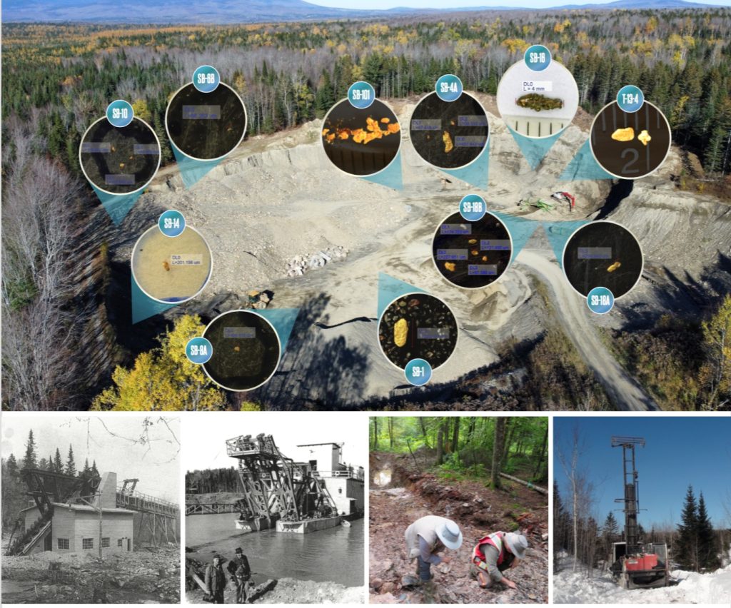
Beauce Gold Fields (Champs D’Or en Beauce) (TSX Venture: ¨BGF¨), (“BGF” or the “Company”): is pleased to present its 2022 sonic drill results on its Ditton Gold project located near the town of Chartierville in southern Quebec. All four holes drilled into the paleoplacer channel contained grains of gold. Notable was hole F-22-10 at 3.36 grams per cubic meter (g/m3) of tertiary placer gold at a depth of 15 meters from the floor of the Landry quarry.
Patrick Levasseur, President and CEO of Beauce Gold Fields, said, “The sonic drill results combined with our dredge and bulk sampling all indicate that the Ditton placer gold channel could be a substantial deposit.” Mr. Levasseur also stated, “These positive results support our continued assessment of the possibility that we hold an economically viable placer gold deposit, as well as to look for signs that could lead to future discoveries of bedrock lode gold.”
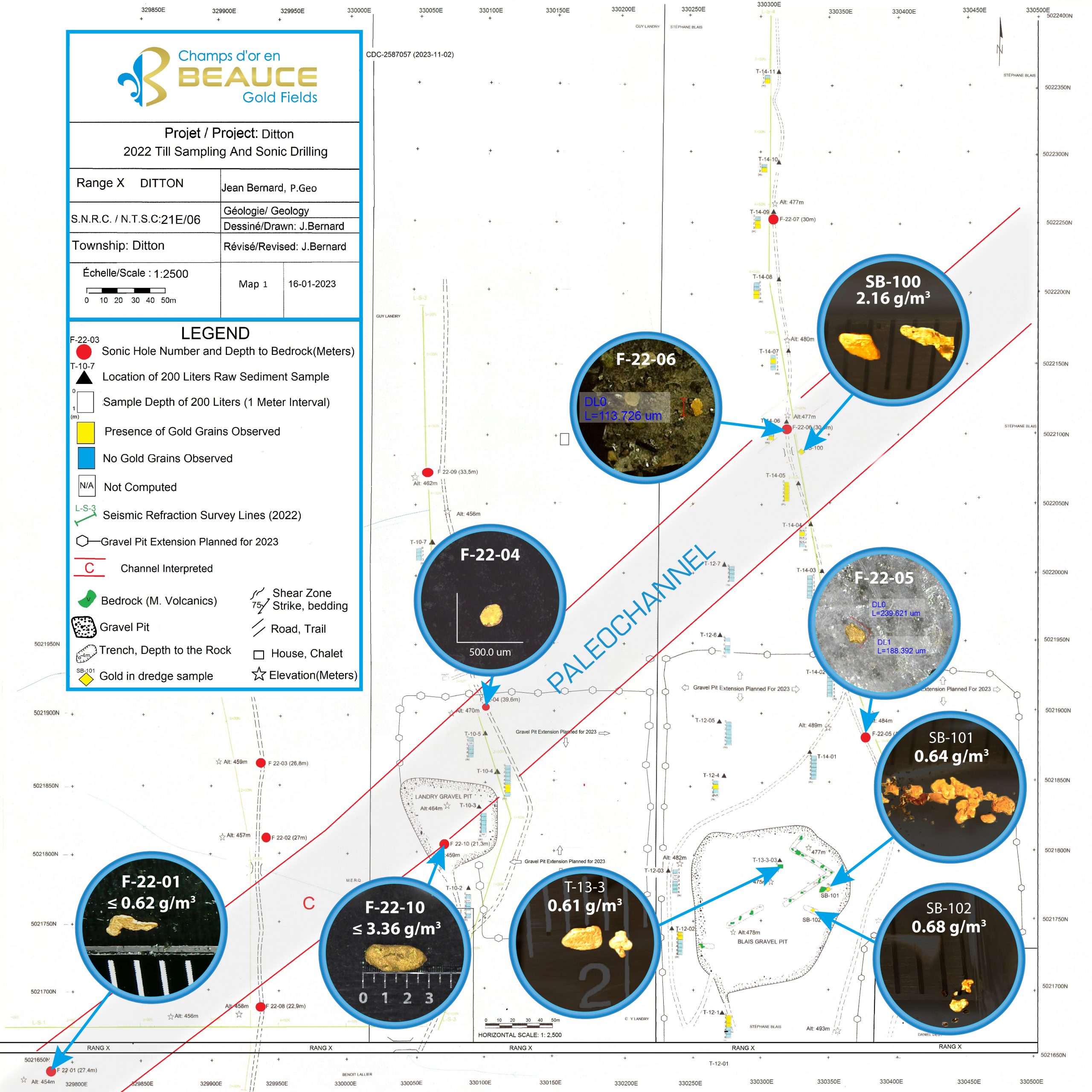
Image1: Exploration Map of the Ditton Project
Sonic Drill Highlights
- Confirms gold anomaly in paleoplacer channel
- Placer channel open to the South, East, SW & NE
- Both Tertiary & Quaternary placer gold identified
- Holes drilled in the Landry and Blais gravel pits contained gold
The industry reporting standard unit of quantity for placer gold is grams per cubic meter.
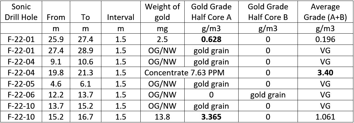
1) Both sets of assays (where applicable) are shown in the included table. One sample (Core A) is from a half 1.5-meter section of a sonic drill core, consistent with CIM mineral exploration best practice guidelines. The latter core (Core B) is presented here to illustrate the range in the variability of the gold grade within the same core sample, demonstrating the grade variability present in placer deposits. A larger volume of samples is necessary to obtain a better representation of the gold content. Therefore, grades are indicative only.
2) OG/NW indicates that the lab technicians observed grains of gold but were unable to recover or manipulate the grain for weighing. VG stands for Visible Gold.
VG stands for Visible Gold.
3) No gold found in holes F-22-02, F-22-03, F-22-07, F-22-08 & F-22-09
The objective of the 2022 exploration program was to locate the preglacial channel using seismic refraction surveys and to drill the indicated depths to bedrock with sonic drilling to eventually locate virgin overburden gravel layers with economic placer gold grades. A second objective was to gain geological data to explore the lode gold source of the gold placers.
The seismic survey, conducted last July 2022 by Geophysics GPR International of Longueuil Inc., utilized instruments capable of locating narrow depressions or faults and identifying old channels. All significant depths suggested by the survey were tested through drilling. The Company discovered oxidized brown clayey gravel intercepted by holes F-22-01 and F-22-10. Additionally, iron-tinged gravel was found on a highly sheared bedrock horizon in the Blais Quarry, which is interpreted as a preglacial channel. This gravel unit is estimated to be approximately 3 meters thick. The objective of the 2023 work will be to measure the thickness of this deposit more accurately through bulk sampling in the operational quarries.
TYPE 1: TERTIARY (Boreholes F-22-01, F-22-10, and the Blais Quarry)
The Tertiary material is still on the bedrock surface and typically buried beneath the quaternary cover (till). Certain topographical conditions, such as deep trenches (Bella Fault) or mountain ranges (Mont Mégantic), which acted as barriers to ice flow, may have facilitated local preservation. The bedrock under the Blais Quarry (Press release May 16, 2023) primarily consists of sheared basalt with a sub-vertical dip or numerous cracks of various sizes filled with products of tertiary weathering (oxidized and compact gravel). These factors combined strongly suggest the presence of intact tertiary materials at the bottom of certain valleys in the Ditton area, where their gold potential is likely to be highest. This material would be interpreted as pre-Lennoxville sediment.
Drill hole F-22-10 intercepted a grain of gold weighing 13.7 mg and measuring over 2.5 mm in length between 80 and 85′ (24.4m-25.9m). Drilling was stopped in rock between 85-90′ (25.9-27.4m) due to broken drill rods in the fractured rock. The material containing the mineralization is considered to be clayey gravel underlain by sheared basalt. Drilling F-22-10 also intercepted a gold-bearing clay gravel between 50 and 55′ near the surface of the fractured rock under the Landry Quarry.
TYPE 2: RECENT QUATERNARY (F-22-04, F-22-05, F-22-06)
On the other hand, the recent Quaternary type consists of unconsolidated deposits resulting from glaciations. The first mechanism involves the massive or partial remobilization of a Tertiary placer deposit and the dispersion of its auriferous content into the Quaternary tills during ice flow. This includes drill holes F-22-04, F-22-06 and F-22-06, where gold particles were found in oxidized brown till. McDonald (1965) discovered a similar deposit north of the Ditton area in highly weathered and oxidized till. This till is considered the second member of the Lennoxville till.
Next, the gold content in the riverbeds that cut through these tills is re-concentrated. The majority of known gold placer showings in the Eastern Townships occur when a contemporary stream or river intersects a sub-outcropping Tertiary placer, releasing and redepositing its gold content at a short distance
The sampled drill cores were treated using gravity separation to test for gold. They were processed at ExploLab in Val D’Or, Quebec. The weight of each core sample varied between 20-25 kg each. The first treatment was a wet classification on Sweco (9.5 mm) sieving to remove the blocks and pebbles. Afterwards, the samples were submitted to the Errol automatic sieve shaker, with three sieves or two sieves depending on the volume of the samples once the pebbles were removed. At the third sieve, a classification at 2 mm, 1 mm and less. At 425 microns or two sieves or 2mm and 1mm. Material less than 1mm or 425 microns was then subjected to a gravimetric concentration on a Wilfley’s table or Gold Wheeel. Once the concentrate has been extracted from the sample, the sample is subjected to drying in an oven for 24 hours and is weighed dry. Under a binocular, gold grains are removed from the concentrates. The sample was then sent to MSALABS in Langley, BC, to assay for fine gold particles or non-visible gold. The results of the lab assays and the weighted gold per sample were combined to obtain indicative grades in grams per cubic meter.
The Company will conduct exploration work this summer and fall to follow up on the drill and dredge results by bulk sampling to verify gold grades within more significant volumes on the Ditton and Emberton properties in Chartierville as well on the Beauce Gold project in St-Simon-les-Mine.
Jean Bernard, B,Sc. Geo., is a qualified person, as defined by NI 43-101, who has reviewed and approved the technical information presented in this release.
A qualified person has not completed sufficient work to classify any mineral resources as defined by National Instrument (NI) 43-101; it is uncertain if future exploration will result in the delineation of mineral resources.
About The Ditton Placer Channel
The placer channel is in the town of Chartierville, Quebec. The channel is 4 km east of the historical Mining Brook Placer gold mine and 6 km northwest of the US-New Hampshire border. It is also located 115 km south of the Company’s Beauce Gold project in St-Simon-Les-Mine.
A sampling program by the Company recovered gold from every sample taken throughout the Ditton quarry (BGF press release January 20, 2022), bringing about the discovery of the Ditton placer gold channel. Further insights to the existence of a channel were gained from the 1980s historical exploration reports of the regional geology and geophysics. It also revealed that the quarry was an excavated pit of an exposed layer of a Tertiary placer channel. Results from the company’s 2022 seismic refraction survey lines further support the existence of a paleochannel.
The channel trends southwest to northeast and is believed to open in both directions.
North American Placer Mines
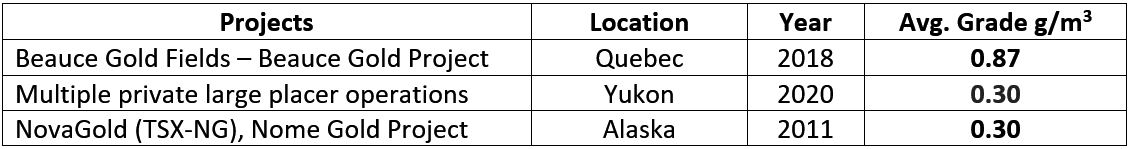
Source: Exploration Target = 0.87 g/m3 Sedar: 43-101 Report – Beauce July 4th 2018, , Author B. Violette,
Yukon Placer Mining Industry Reports 2010-2014, 2018-2020:Yukon Geological Survey
NovaGold Resources: TECHNICAL REPORT NOME PLACER PROPERTY, 2006, Norwest Corporation
Potential for Lode Gold Discoveries
The recovered gold grains from showed delicate angular shapes suggesting little transportation. A proximal bedrock source of the placer channel could be from the eroded Eastern flank of the valley wall. The bedrock lithology holds a contact point between altered volcanic rock and schist rock. Historical surveys indicated strong magnetic lineaments favorable to hosting gold-bearing quartz lenses.
The Bella Fault line is estimated to run along strike 1 km east of the placer channel where Cache Exploration in 1985 put down 3 diamond drill holes (DDH) along Rang Dix road to test a strong shear zone. The holes intersected andesites containing numerous quartz stringers mineralized with pyrite and much tourmaline. Of interest, in the drill log for DDH number S-2 states that visible gold was noted at 240 meters (GM42843). Cache did not complete the recommended follow-up drilling to test this anomaly.
About Beauce Gold Fields
Beauce Gold Fields is a gold exploration company focused on placer to hard rock exploration in the Beauce region of Southern Quebec. The Company’s objective is the trace old placer gold workings back to a bedrock source to uncover economic lode gold deposits. The Company’s flagship property is the St-Simon-les-Mines Gold project site of Canada’s first gold rush that pre-dates the Yukon Klondike. The Beauce region hosted some of the largest historical placer gold mines in Eastern North America that were active from 1860s to the 1960s It produced some of the largest gold nuggets in Canadian mining history (50oz to 71oz). (Source Sedar: 43-101 Report – Beauce July 4th 2018, , Author B. Violette)
Beauce Gold Fields website www.beaucegold.com
For further information contact
Patrick Levasseur, President and CEO Tel: (514) 262-9239
www.beaucegold.com
Disclaimers:
This press release contains certain forward-looking statements, including, without limitation, statements containing the words “may”, “plan”, “will”, “estimate”, “continue”, “anticipate”, “intend”, “expect”, “in the process” and other similar expressions which constitute “forward-looking information” within the meaning of applicable securities laws. Forward-looking statements reflect the Company’s current expectation and assumptions, and are subject to a number of risks and uncertainties that could cause actual results to differ materially from those anticipated. These forward-looking statements involve risks and uncertainties including, but not limited to, our expectations regarding mineral exploration. Such statements reflect the current views of the Company with respect to future events and are subject to certain risks and uncertainties and other risks detailed from time-to-time in the Company’s on-going filings with the securities regulatory authorities, which filings can be found at www.sedar.com. Actual results, events, and performance may differ materially. Readers are cautioned not to place undue reliance on these forward-looking statements. The Company undertakes no obligation to publicly update or revise any forward-looking statements either as a result of new information, future events or otherwise, except as required by applicable securities laws.
Neither the TSX Venture Exchange nor its Regulation Services Provider (as that term is defined in the policies of the TSX Venture Exchange) accepts responsibility for the adequacy or accuracy of this release.