
Metals Creek drills 7.45 metres of 7.25 g/t gold at Ogden Project, Ontario
Metals Creek Resources Corp. [TSXV: MEK; OTC Pink: MCREF; FRA: M1C1] has released high-grade gold assays for the final diamond drill hole from the recently completed three-hole diamond drill program at the Ogden gold project located in Timmins, northeastern Ontario. The Ogden gold project is a 50/50 joint venture with Discovery Mining Ltd., with the company serving as the operator.
This program entailed three diamond drill holes on the Thomas Ogden zone (TOG), totalling 1,233 metres targeting the eastern plunge of a fold structure which has a shallow easterly plunge. TOG is host to gold-bearing strongly altered conglomerates and felsites with associated quartz veins and pyrite, as well as gold-bearing, flat-lying secondary structures with associated quartz and pyrite.
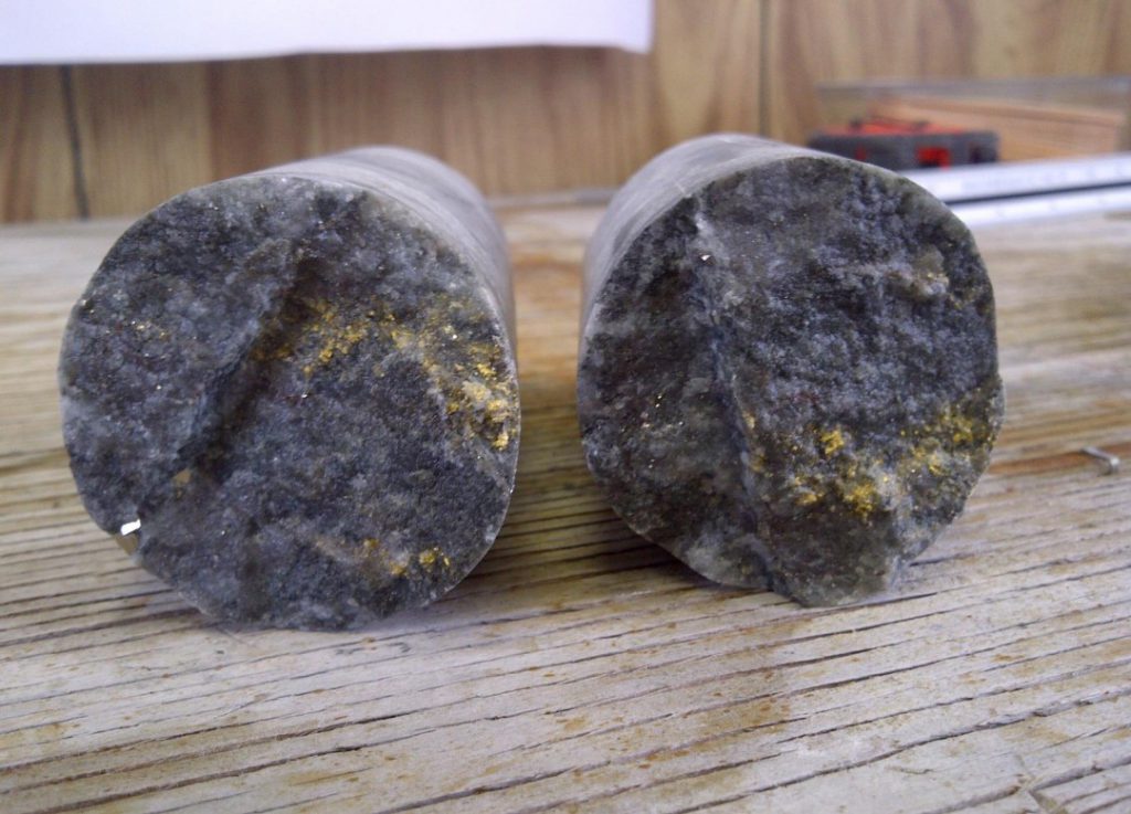
TOG-26-77 returned high-grade gold mineralization with a downhole intercept of 7.25 g/t gold over 7.45 metres (347.27 to 354.72 m), including 13.46 g/t gold over 2.54 mettres with associated visible gold (VG). This hole was planned to further define the lower portion of a fold structure, with this drill hole being the deepest of the recently completed program.
Mineralization is hosted within strongly carbonate altered and silicified felsites and strongly albitized conglomerates with associated pyrite and minor arsenopyrite. Strong quartz veining is present within both units at various orientations, including VG in two locations.
Hole TOG-26-77 was an undercut of hole TOG-26-75, which returned a downhole intercept of 40.61 g/t Au over 2.60 metres. Mineralization consists of finely disseminated and cubic pyrite with minor arsenopyrite hosted within altered felsite and conglomerate. Quartz veins appears to increase when in close proximity to the axial plane on the fold structure.
Fuchsite is locally present with quartz along cross-cutting healed fractures. Higher-grade gold mineralization has a strong spacial association with strong to intense folding, the emplacement of quartz veining as well as significantly stronger hydrothermal alteration. A second zone of mineralization was encountered at the northern contact between the footwall intermediate dike and the ultramafics. The mineralized intermediate dike returned a downhole intercept of 1.15 g/t Au over 4.65 metres (374.52 to 379.17 m). Mineralization consists of disseminated and cubic pyrite with local quartz veining. Units are moderately to strongly silicified increasing downhole.
The high-grade gold results from this program have demonstrated that the deeper portion of TOG has potentially similar gold tenor to that of the shallower portion of the fold structure to the west. Hole TOG-26-76 returned the second highest grade intercept to date on the Ogden project, returning a downhole intercept of 115.51 g/t Au over 9.85 metres hole. TOG-13-25 returned an intercept of 210.19 g/t Au over 12.53 metres, making this the highest intercept to date and is located 325 metres west of TOG-26-76 along the fold structure.
It is especially encouraging that all three holes from this program encountered visible gold where historically 35 per cent of TOG holes have VG.
Metals Creek Resources is a reporting issuer in Alberta, British Columbia and Ontario. Metals Creek has earned a 50% interest in the Ogden gold property, including the former Naybob gold mine, located six km south of Timmins, Ont., and has an eight km strike length of the prolific Porcupine-Destor Fault.
Metals Creek has also jointly acquired through staking on a 50/50 basis with Benton Resources, potential natural white hydrogen projects in Newfoundland. The Smoking Gun prospect was selected after research uncovered highly anomalous helium with values up to 8,900 parts per billion (ppb) in water collected from an historic drill hole. These licences are located within the Deer Lake basin, which is thought to be a prospective environment for the presence helium (He) and natural (white) hydrogen (H2).
At Parson’s Pond, research of historical drill logs in two holes 14.2 km apart, have observed C1 methane gas levels reaching 72%. The area is underlain by thrust faulted rocks of the Humber Arm supergroup. Drill logs indicate unique sedimentary units composed of shales along with sandstones containing fragments of serpentine and chrome.
Of particular interest, is the presence of the mineral glauconite, which, combined with these geological indicators, suggests a highly prospective environment for the potential formation of white hydrogen (natural hydrogen) to form within the basin. The presence of such high concentrations of methane alongside hydrogen indicators suggests a potentially active gas system within the basin. In addition, surface areas have been noted to vent gas within the project boundaries.
Resource World Magazine Inc. has prepared this editorial for general information purposes only and should not be considered a solicitation to buy or sell securities in the companies discussed herein. The information provided has been derived from sources believed to be reliable but cannot be guaranteed. This editorial does not take into account the readers investment criteria, investment expertise, financial condition, or financial goals of individual recipients and other concerns such as jurisdictional and/or legal restrictions that may exist for certain persons. Recipients should rely on their own due diligence and seek their own professional advice before investing.