
QIMC Unveils Landmark Geophysical Survey Findings in its natural hydrogen Ville Marie project
Quebec Innovative Materials Corp. (CSE: QIMC) (FSE: 7FJ) (“QI Materials”, “QIMC” or the “Company”), is proud to announce the very successful results of the non-invasive geophysical surveys conducted in the St-Bruno-de-Guigues area of Témiscamingue. These surveys were commissioned by QIMC to its partner the INRS following the detection of high hydrogen soil-gas anomalies during its summer soil sampling covering an area of 80km2.
“We are thrilled with the outcome of these geophysical surveys on the first 3 lines measured, said John Karagiannidis, CEO of QIMC. ” The results are in line with our expectations and further confirms Professor Marc Richer-Lafleche hydrogen model of a deep seated hydrothermal source. Even without drilling data, the anomalies seen in the imagery along line 1 suggest a break in the clay horizon’s integrity, potentially allowing hydrogen to migrate to the surface. Also, the disturbances on line 3, combined with strong hydrogen soil anomalies, point to the likely presence of gas in the sediments. This geophysics data provides a clear and detailed understanding of the Quaternary geology underlying the hydrogen anomalies and the reservoirs. These findings are critical for future exploration and natural hydrogen development in our natural hydrogen Ville Marie project, as they provide a comprehensive understanding of the area’s geology, faulting and gas seepage dynamics reservoir structures”
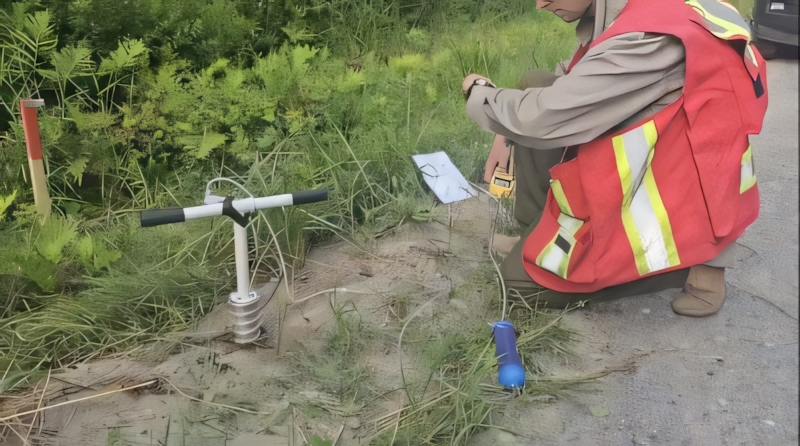
To document the characteristics of the terrain beneath these high hydrogen soil anomalies, QIMC partnered with the Institut national de la recherche scientifique (INRS) to carry out cutting-edge geoelectric tomography (GTS). This technique allows for the detailed mapping of subsurface geological features without the need for invasive stratigraphic drilling.
Surveys
The first survey (figure 1), carried out in October 2024, involved the production of sub-surface imagery with very high spatial resolution (inter-electrode distance spacing of 5 m). This will be followed, in November 2024, by a geoelectric tomography survey with a vertical penetration of the order of 350 m (inter-electrode distance spacing of 20 m), and subsequently by an audiomagnetotellurics (AMT) survey with high vertical penetration of the kilometer order. Being particularly sensitive to the presence of electrical discontinuities associated with faults, this method should make it possible to locate and prioritize the importance of faults associated with the Témiscamingue graben. Concurrently with these surveys, a gravity survey (50m stations) is being currently carried out to document regional variations in the thickness of the sedimentary rock basin.

Figure 1. Line 1 survey line and line 3 East and North survey lines
Objective
One of the objectives of INRS and QIMC is to identify areas of maximum thickening of the sedimentary rock sequence overlying the Archean basement in order to identify the most likely places for the reservoirs. This objective should be easy to achieve, given the difference in density between the Proterozoic and Ordovician sedimentary rocks and the volcanic and intrusive rocks of the Baby Group (greenstone belt).
The data generated by the galvanic and electromagnetic geoelectric surveys will also be used to optimize the injection and recording parameters for the electromagnetic data (TDEM) to be measured in winter 2024 going into early 2025. The latter will be acquired using a mobile ground-based system capable of producing electrical resistivity and electrical chargeability sections with vertical penetration of the order of 100-200 m and horizontal resolution of the order of 15 cm. This system is essential for locating fractures and faults masked by glaciolacustrine deposits, and for distinguishing Ordovician sedimentary rocks (less resistive) from Proterozoic sedimentary rocks (more resistive).
Geoelectric tomographic survey
The INRS team carried out a very high-resolution geoelectrical tomography (electrical resistivity and chargeability) survey to produce electrical resistivity and chargeability imagery along lines 1 and 3Est and north of line 3E. The objectives of the survey were to: 1) provide imagery to assess overburden thickness variability, 2) clarify the stratigraphy of Quaternary sediments overlying sedimentary rocks, and 3) verify that the strong hydrogen anomalies detected during the Soil-Gas survey are not associated with simple sulfide weathering processes. “This last point is critical”, notes Professor Marc Richer-Laflèche, head of INRS’ Applied Geoscience Laboratory, “as the aim of the project is to locate hydrogen anomalies originating from deep-seated sources, rather than small local anomalies associated with the weathering of sulphides located at the contact between mineralized bedrock and local groundwater. “
The survey was carried out using a Terameter LS (10 channels) and multi-connector cables. Acquisitions were carried out in gradient mode. Zond RS2D software was used for quality control, data inversion and 2D imaging.
“The results obtained indicate that geoelectrical tomography is an effective method that works remarkably well in the electrically conductive terrain of St-Bruno-de Guigues” states Professor Richer-Laflèche. “In the very high spatial resolution acquisition mode, the method reveals the presence of several sedimentary horizons in the Quaternary sequence, and pinpoints the position of the contact with the rocks of the sedimentary basin.”
Section Line 1
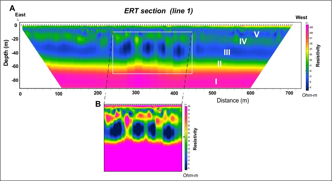
Figure 2. A) High-resolution geoelectrical tomographic imaging of a portion of the rang IV road (line 1: rte du 4ième rang) in St-Bruno-de-Guigues. B) Contrast enhancement by scaling electrical resistivity values. Modeling and 2D data inversion: M.R. LaFlèche).
Section along line 1 (rte du quatrième rang): This survey was carried out in the area of the first hydrogen anomaly discoveries (July 2024) in the northern part of St-Bruno-de-Guigues. The section clarifies the contact between bedrock (between I and II) and the Quaternary sequence, comprising some 5 units (II: sand and gravels; III: clays; IV: sands; V: clays and silty sands at the top)(Fig. 2 a). “The imagery obtained along line 1 also shows significant heterogeneity, particularly affecting horizon III, which according to our model would be a low-permeability clay-rich horizon (Fig. 2b)” notes Professor Richer-Laflèche. “Despite the absence of drilling in this area, we believe that this anomalous domain marks a break in the tightness of a clay horizon”, continues Professor Richer-Laflèche, “allowing gases such as hydrogen to ascend to the sub-surface and soils.”
Section north of line 3E
This 1500m-long section was laid parallel to line 3E to avoid electrical interference associated with a transmission line located along chemin du Quai (line 3E). Note that the Soil-Gas survey for line 3E reported very strong hydrogen anomalies that could not be explained by surface observations.
“The section shows a more complex geological and topographical context than line 1 (Fig. 3a). In the central part, the bedrock becomes sub-outcropping sub-flush (I) (Lorrain Fm sandstone) and shows more conductive sub-vertical anisotropies, which we interpret as major fractures that could be important in the process of hydrogen transfer to the surface(VI and VII)” states Professor Richer-Laflèche. “Note that these fractures (or faults) affect sub-horizontally dipping sedimentary rocks. As with the Line 1 section, it shows the presence of sandy-gravelly (III and IV) and silty-clay (V) sediments (Fig. 3a), which also appear disturbed in sectors VIII and IX (Fig. 3b and C). Despite the absence of drilling data at present, we interpret these disturbances as electrical resistivity anomalies related to the probable presence of gas in the sediments, as they are located in an area characterized by strong hydrogen anomalies in the soils (ref. Soil-Gas survey on line 3 East).”
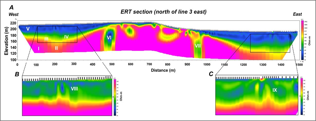
Figure 3. A) High-resolution geoelectric tomographic imagery calculated from data collected along a section located north of Chemin du Quai (line 3E)in St-Bruno-de-Guigues. B and C) Contrast enhancement by scaling electrical resistivity values. Modeling and 2D data inversion: M.R. LaFlèche.
Probable origin of disturbances observed in high-resolution ERT imagery
The presence of sub-vertical electrical resistivity anisotropies, affecting glaciolacustrine sediments, could be explained by different geological processes. Given the seismic context of the region, the increase in electrical resistivity values in silty clays could be explained, among other things, by the emplacement of non-cohesive sand dykes in cohesive silty-clay sediments. In fact, an earthquake-related sand eruption was observed in the Témiscamingue graben Northeast of New Liskeard (Doughty et al., 2010). “We believe that the presence of sub-vertical sandy dykes (more porous and permeable) could promote the ascent of hydrogen through the clay-silt cover (impermeable) and thus produce hydrogen anomalies in the soils.” states Professor Richer-Lafèche. “Also, locally, if the gas flow is significant (advective flux sectors), subvertical resistive anomalies could be linked to the presence of significant quantities of gas, thus explaining a localized increase in electrical resistivity values.” This will be further confirmed by geotechnical drilling planned for Spring 2025.
“Deeper data, located in the sandstone horizon of the Lorrain Formation (Cobalt Gp), suggest that despite the sub horizontal nature of the stratification of the sandstone units, these rocks appear fractured and probably faulted,” notes Professor Richer-Laflèche. “This is underlined by a sharp drop in electrical resistivity values. This type of rock discontinuity could be an exploration vector for advective gas flow zones in Proterozoic, Ordovician and Silurian sedimentary rocks of the Témiscamingue graben.”
“The successful results of these surveys mark a significant step forward in QIMC’s efforts to explore and harness Ville Marie’s natural hydrogen resources in a responsible and sustainable manner.” continues John Karagiannidis, president of QIMC. The data collected from the geophysical surveys will be further analyzed and integrated into QIMC’s ongoing exploration strategy for the region, ensuring that future developments are grounded in sound geological understanding.
QIMC will continue to engage with local stakeholders and provide updates as the project progresses. The company is committed to maintaining transparency and fostering positive relationships with the community throughout this process.
Reference:
Doughty, M., Eyles N., and Daurio, L., 2010. Ongoing Neotectonic Activity in the Timiskaming – Kipawa Area of Ontario and Québec. Geoscience Canada, Volume 37, Number 3, September 2010, pp.95-146
About the INRS and Pr. Marc Richer-LaFlèche, P.Geo.
The Institut National de la Recherche Scientifique (“INRS”) is a high-level research and training institute. Pr. Richer-LaFlèche’s team has exceptional geological, geochemical and geophysical experience specifically in the regions of QIMC’s newly acquired claims. They have carried out over six years of geophysical and geochemical work and collected thousands of C1-C4 Soil-Gas analyses.
M. Richer-LaFlèche also holds an FRQNT grant, in partnership with Quebec MRN and the mining industry, to develop and optimize a Soil-Gas method for the direct detection of mineralized bodies and faults under Quaternary cover. In addition to sulphide gases, hydrogen was systematically analyzed in the numerous surveys carried out in 2023 in Abitibi, Témiscamingue and also in the Quebec Appachian. M. Richer-LaFlèche is the Qualified Person responsible for the technical information contained in this news release and has read the information contained herein.
In addition, the INRS team has several portable gas spectrometers and the sampling equipment and logistics necessary for taking gas samples and geophysical measurements on the ground or in the aquatic environment. He is a professional geologist registered with the Ordre des géologues du Québec and is the Qualified Person responsible for the technical information contained in this news release and has read and approved the information contained herein.
For more information about Quebec Innovative Materials Corp. and its products, please visit www.qimaterials.com
About Québec Innovative Materials Corp.
Québec Innovative Materials Corp. is a mineral exploration, and development company dedicated to exploring and harnessing the potential of Canada’s abundant resources. With properties in Ontario and Québec, QIMC is focused on specializing in the exploration of white (natural) hydrogen and high-grade silica deposits, QIMC is committed to sustainable practices and innovation. With a focus on environmental stewardship and cutting-edge extraction technology, we aim to unlock the full potential of these materials to drive forward clean energy solutions to power the AI and carbon-neutral economy and contribute to a more sustainable future.
QUÉBEC INNOVATIVE MATERIALS CORP.
John Karagiannidis
Chief Executive Officer
Tel: +1 438-401-8271
For further information, please contact:
Email: info@qimaterials.com
Neither the Canadian Securities Exchange nor its Regulation Services Provider (as that term is defined in the CSE policies) accepts responsibility for the adequacy or accuracy of this news release and has neither approved nor disapproved the contents of this news release.
Forward-Looking Statements
This news release contains statements that constitute “forward-looking statements”. Such forward-looking statements involve known and unknown risks, uncertainties and other factors that may cause Québec Innovative Materials’ actual results, performance or achievements, or developments in the industry to differ materially from the anticipated results, performance or achievements expressed or implied by such forward-looking statements. Forward-looking statements are statements that are not historical facts and are generally, but not always, identified by the words “expects,” “plans,” “anticipates,” “believes,” “intends,” “estimates,” “projects,” “potential” and similar expressions, or that events or conditions “will,” “would,” “may,” “could” or “should” occur.
Although Québec Innovative Materials believes the forward-looking information contained in this news release is reasonable based on information available on the date hereof, by their nature, forward-looking statements involve assumptions, known and unknown risks, uncertainties and other factors which may cause our actual results, performance or achievements, or other future events, to be materially different from any future results, performance or achievements expressed or implied by such forward-looking statements.
Examples of such assumptions, risks and uncertainties include, without limitation, assumptions, risks and uncertainties associated with general economic conditions; adverse industry events; future legislative and regulatory developments in the mining sector; the Company’s ability to access sufficient capital from internal and external sources, and/or inability to access sufficient capital on favorable terms; mining industry and markets in Canada and generally; the ability of Québec Innovative Materials Corp. to implement its business strategies; competition; and other assumptions, risks and uncertainties.
The forward-looking information contained in this news release represents the expectations of the Company as of the date of this news release and, accordingly, is subject to change after such date. Readers should not place undue importance on forward-looking information and should not rely upon this information as of any other date. While the Company may elect to, it does not undertake to update this information at any particular time except as required in accordance with applicable laws.