
Starcore Int’l Mines exploring Kimoukro, Ivory Coast
Starcore International Mines Ltd. [TSX-SAM; FK-V4JA] has begun exploration work on the Kimoukro permit in the central Ivory Coast, approximately 30 km south of the country’s capital, Yamoussoukro. The permit was recently granted to the Ivorian Company, K Mining SARL, on May 22, 2024, with whom Starcore has a mineral property option agreement to explore K Mining’s properties.
The initial field activities include building of the main camp and a private access road stretching 5 km from the paved road A4 near the village of Kimoukro, into the permit boundary; an induced polarization (IP) geophysical survey, and ground magnetic survey.; trenching over known mineralised structures and over geophysical targets; and auger drilling campaign in saprolite and soil.
SAGAX Afrique sarlu (Sagax), has been retained to implement the IP and ground mag program, which is anticipated to be completed by the end of July 2024. Sagax is a highly respected and reputable geophysical contractor led by Jean David, and has extensive experience on a large variety of mineral systems, including similar Birimian-hosted lode gold deposits throughout West Africa.
Geo-Explo Services, an auger drilling supplier company based in Yamoussoukro, will be contracted for an initial 2,000-metre auger drilling program.
Camp building, earthworks and trenches will be done by using either a local contractor or K Mining personnel and equipment.
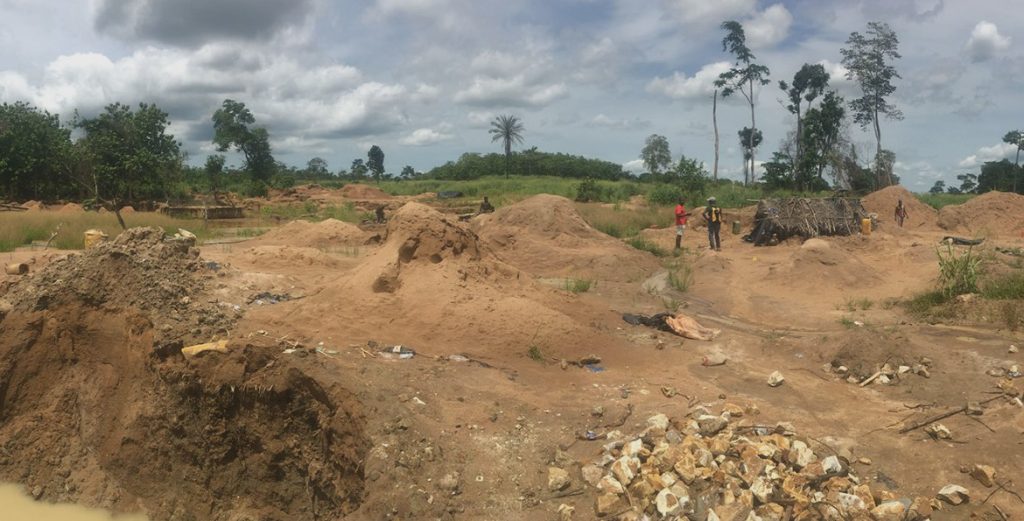
The Kimoukro permit belongs to an area of widespread artisanal mining activity, traditionally linked to the community of nearby Kokumbo. Inside the permit, a number of quartz veins are currently exploited or have been exploited by artisanal miners. At least 11 different gold-mineralized veins were mapped in the field and by trenches.
The current interpretation is that the veins are interconnected in a persistent NW-striking shear-extensional system, accompanied by minor structures and veins of higher order. The thickness of the most developed veins seems to range from 0.5 to 1.0 metre and their inferred strike length is over 150 metres. The bulk of the known mineralized veins extends from surface and is exploited by artisanal miners by means of shafts and trenches to a depth of 10-15m; yet deeper shafts exist up to +40 metres deep, and in this case, explosives are used to progress.
Soil geochemistry was completed by K Mining between 2019 and 2022, thence audited with twin samples and expanded in 2023, highlighted over 65 hectares of soil anomaly >50 ppb. However, the surface samples only reached depths of 0.5 m to 1 metre; thus, the actual gold anomaly in the alluvial areas, or where cover is present, was not depicted. The bias is also evident through other evidence including the presence of artisanal work. In fact, the visit to artisanal mineworks led to the clear identification of several NW trending vein systems. Some of the exploited veins are outside the soil anomaly depicted by surface soil samples.
Previous exploration work completed in the Kimoukro permit by K Mining included two separate blocks of IP surveys in 2019 and 2021, covering 0.9 km2 and 1.3 km2 respectively. Those surveys have been reprocessed and reinterpreted by Dr. Paolo Costantini, a renowned geophysicist, principal of ArsTerra Exploration GmbH.
According to the few existing trenches and the previous geophysical surveys, the depth to rock ranges from 2 to 20 m, with an average of some 10 m. The relation among the mineralised structures and several NW and NE-trending structures were highlighted.
The initial target area for the exploration will be limited to the central part of the permit, east of the Bandama river and north of the paved road A4 and the village of Kimoukro. The majority of the existing exploration data comes from this area.
The IP program will comprise 50 total line-km of ground IP surveys focused on already identified soil anomaly and a number of mineralized quartz-veins which are being exploited by artisanal works.
The IP data will be acquired using a pole-dipole electrode array with a dipole spacing of 25 metres expanded through 4 separations readings (a=4×25; 3×50; 2×75; 1×100). A total of 40 profiles oriented N105degree, spaced 100 metres apart, will be surveyed for a total of some 50 line-km. The interpretation and 3D modelling of the survey results (chargeability and resistivity) will be conducted by Jean David, the Principal Geophysicist at Sagax.
Over the same lines, a ground-magnetic survey will be conducted.
The surveys are designed to provide sufficient understanding of major and minor structures, and distribution of the late granitoids intruding the volcano-sedimentary sequence, as well as depth of the solid rock (saprock), and better understanding of the in-situ shallow gold anomaly.
An auger drilling campaign of some 2,000 metres will be performed, in order to better image the gold anomaly in the saprolite, at different depths. The initial auger drilling program aims to test the on-strike continuity of the known mineralized veins, as well as the poorly defined areas, including where exploited artisanal minework indicates the presence of mineralized veins, which should result in wider gold anomaly in-situ soil and saprolite.
Trenches will be cut by using an excavator, initially to test the known higher gold anomaly zones, orthogonal to the main vein system. Trenching will commence at the advanced stages of road building. The initial trench program consists of a total of 1,500 metres of trenches, 5 m deep, stretching up to 120 metres.
Starcore aims to conclude all these activities before the heavy rain season, which is typically in September.
Data from the new surveys, corroborated by the improved geochemical sampling from auger drilling and trenching, will help improve Starcore’s understanding of the known and newly identified prospective areas, and should bring them to a drill-ready stage.
Starcore aims to finalize an initial campaign of diamond drilling right after the rainy season. The diamond drilling aims to test the mineralised veins and to describe the geological context in this area of generally poor outcrop exposure.