
Gold Terra drills 6.40 g/t gold over 3.4 metres in Zone 14-24, North Belt Area, Walsh Lake Gold Corridor, Northwest Territories
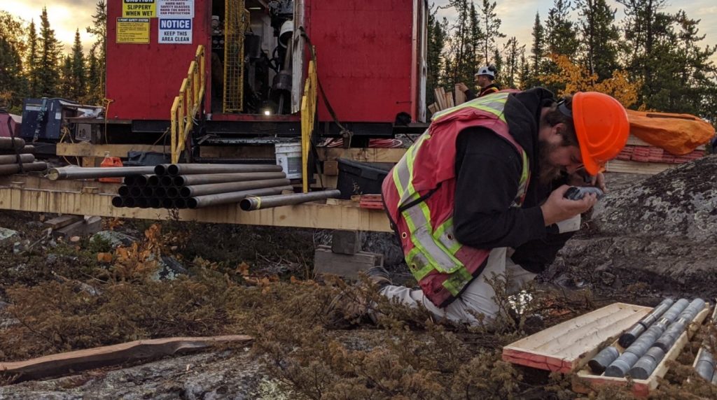
Gold Terra Resource Corp. [TSXV: YGT; Frankfurt: TX0; OTCQB: YGTFF] reported additional assay results from the 2026 Winter Drill Program designed to expand the Walsh Lake gold corridor situated in the company’s 100%-owned Yellowknife Project, Northwest Territories. Assay results include drill hole GTWL26-029 which intersected 6.40 g/t gold over 3.4 metres from 30.6 metres to 34.0 metres downhole in the north area of the Walsh Lake corridor. The assays for the south part of the Walsh Lake corridor are pending.
Chairman and CEO, Gerald Panneton, commented, “We always welcome more success from our completed 2026 winter drilling program in the Walsh Lake gold corridor. Zone 14-24 is the result of extending zone 14 with zone 24 over a strike length of 300 metres. The 14-24 zone is open in all directions and only drilled sporadically. We are only starting to scratch the surface of the Walsh Lake area, and we already know that the area is very well endowed in multiple high grade gold structures that requires more drilling next winter. The area is also situated just 20 km north of the City of Yellowknife and complements our potential restart of the historic Con Mine once the purchase is completed.”
Extending Zone 14-24 (formerly Zone 14): The Walsh Lake area has high potential to further expand this mineralized gold corridor. In 2022, 19 holes for 6,011 metres were completed extending gold mineralization in the Pickel area with the addition of two new gold zones, the Pickel and Zone 14. The 2026 drilling completed another nearly 5,000 metres of drilling delineating a third mineralized zone, Zone 24, and expanding the Walsh Lake corridor to an area of 700 metres by 200 metres.
Previously announced hole GTWL26-24 confirmed the northern extension of the broad Walsh Lake Gold corridor hosted in metasediments some 150 metres north of known mineralization.
The hole intersected two very good gold mineralization zones separated by 200 metres with multiple visible gold specks (22.46 g/t Au (uncut) over 5.7 metres from 119.6 metres to 125.3 metres downhole, including 198 g/t over 0.5 metres starting at 119.60 metres).
The discovery extension of this zone shows excellent potential for the area and will warrant further drilling next winter.
Assay Highlights: The 2026 winter program in the Northbelt-Walsh Lake area commenced on January 22 and concluded on March 21, 2026, using two drill rigs for a total of 4,904.9 metres with 15 holes completed. The main objective was to test the best area uncovered in the previous winter 2022 program and to extend the known gold corridor beyond the previously drilled 500-metre strike length.
Additional assays have been returned for six additional holes in the north area of the Walsh Lake gold corridor. Assay results for Zone 14-24 included drill hole GTWL26-025 that returned 1.11 g/t Au over 17.5 metres. GTWL26-025 intersected 1.11 g/t Au over 17.5 metres from 139.5 metres to 157 metres. Locally within this interval sulphide percentages of replacement style pyrrhotite and arsenopyrite range from 3% up to 15%. Multiple veins were observed within the interval including smokey quartz veins and sporadic salt and pepper veins more typically observed throughout the Walsh Lake Area.
GTWL26-029 returned 6.40 g/t Au over 3.4 metres.
GTWL26-029 intersected 6.40 g/t Au over 3.4 metres from 30.6 to 34 metres, hosted in smokey quartz veins often hosting sphalerite, and exhibits a mineralization style that is similar to hole GTWL26-024 suggesting a broader mineralized zone.
GTWL26-031 and GTWL26-033: No significant values as some of the strike-extensions of known gold zones were unsampled at the time but will be sampled and re-evaluated.
This news release reports the assay results from six drill holes from which 949 core samples were assayed. Assays results range from non-detectable gold to a highest assay of 9.24 g/t Au.
Gold Terra has recently staked some new ground immediately north of Con Mine property. The staking took place on May 21, 2026 and covered an area that was open for staking at the time.
The Yellowknife Project (YP) encompasses 836 km2 of contiguous land immediately north, south and east of Yellowknife, Northwest Territories. Through a series of acquisitions, Gold Terra controls one of the six major high-grade gold camps in Canada. Being within 10 km of Yellowknife, the YP is close to vital infrastructure, including all-season roads, air transportation, service providers, hydro-electric power, and skilled tradespeople. Gold Terra is currently focusing its drilling on the Campbell Shear, where approximately 14 Moz of gold has been produced and most recently on the CMO property claims immediately south of the past producing Con Mine which produced 6.1 Moz between the Con, Rycon, and Campbell shear structures (1938-2003).
The YP and CMO properties lie on the Yellowknife greenstone belt, covering nearly 70 km of strike length along the main mineralized shear system that hosts the former-producing high-grade Con and Giant gold mines. The Company’s exploration programs have successfully identified significant zones of gold mineralization and multiple targets that remain to be tested which reinforces the company’s objective of re-establishing Yellowknife as one of the premier gold mining districts in Canada.
Resource World Magazine Inc. has prepared this editorial for general information purposes only and should not be considered a solicitation to buy or sell securities in the companies discussed herein. The information provided has been derived from sources believed to be reliable but cannot be guaranteed. This editorial does not take into account the readers investment criteria, investment expertise, financial condition, or financial goals of individual recipients and other concerns such as jurisdictional and/or legal restrictions that may exist for certain persons. Recipients should rely on their own due diligence and seek their own professional advice before investing.