
Bathurst Metals drills 0.20 oz/ton gold over 16.73 feet at Peerless, British Columbia
Bathurst Metals Corp. [TSXV-BMV; OTC-BMVVF] reported assay results from the company’s first diamond drilling program on its Peerless project located in the Bralorne mining camp area of British Columbia. Hole PR24-04 returned 0.20 ounce/ton gold over 16.73 feet, including 0.63 oz/ton gold over 3.61 feet.
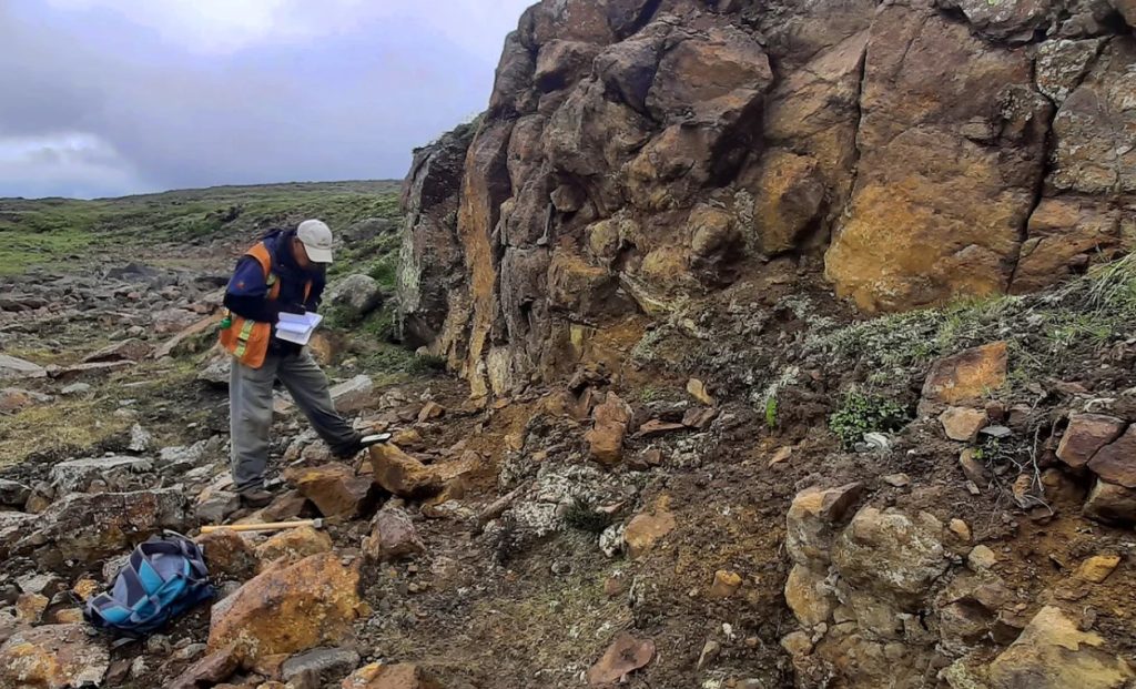
The drill program was designed to test for the presence of an east-west-trending structure, which could be important in gold deposition. The program was clearly successful and obtained potential economic gold values along the structure and within the surrounding ultramafic host. While ultramafics are typically poor hosts for gold deposits, this unexpected success indicates a potentially larger gold system nearby. The program comprised four HQ-sized diamond drill holes, totalling 702 metres.
Key points: Discovery of near-surface, gold-bearing east-west-trending structures; significant gold mineralization occurs within ultramafics, away from a crosscutting thrust fault. Ultramafics are typically a poor host for gold deposits, yet the company encountered potentially economic gold grades.
The drilling program has yet to test the contacts between the volcanoclastic rocks and the ultramafic rocks where the east-west structure intersects. These structural intersections, but not exclusively within, the ultramafics are essential for the formation of gold deposits in the Bralorne mining camp.
The technical team has delineated several important anomalous gold and base metal soil geochemistry targets where additional east-west structures occur and crosscut a property-scale thrust fault.
Hole PR24-004 was the closest but did not test the lithological contact and intercepting structures targeted.
Drill hole PR24-004 returned 16.7 feet of 0.20 oz/ton gold (6.3 g/t), including 3.6 feet of 0.63 oz/ton (19.5 g/t gold).
Lorne Warner, PGeo, president , stated: “We were very successful in our first drilling program to consistently locate and encounter significant concentrations of mesothermal, sulphide mineralization in the primary east-west-trending structure we believe is responsible for the main gold mineralization event. Observing visible gold helps as well. A key observation from this drill program is that as we proceeded to get closer to the structural intersection of the ultramafic unit to the metasediments-volcanoclastics, gold concentrations increased significantly. We also located a second similar structure during drilling in hole PR24-01, both of which remain open along strike and to depth.”
All four holes were contained within listwanite-altered ultramafics. When crosscutting the east-west structure, significant gold mineralization was encountered, including visible gold.
Hole PR24-001, Azimuth 24.3, dipping -45 degrees ended at 222.0 metres. At the 197-199 metre interval the hole encountered a zone of significant quartz veining and pyrite, arsenopyrite concentrations with minor galena, sphalerite, and traces of chalcopyrite mineralization. The ultramafic unit was silica flooded and represents a second east-west structure as indicated by magnetic surveys. Assay results returned 0.61 g/t gold over a 2.0-metre core length but also contained highly anomalous concentrations of nickel, arsenic and zinc.
Hole PR24-002, Azimuth 320 degrees, dipping -45 degrees, ended at 198.0 metres. The hole encountered strong sulphide mineralization from 38.0-40.0 metres down-hole consisting of extensive arsenopyrite, sphalerite and traces of chalcopyrite. Assay results were 0.20 oz/ton gold over 6.56 feet (5.72 g/ gold over 2.0 metres) including 0.39 oz/ton gold over 3.61 feet (11.1 g/t over 1.0 metres) from 39.0-40.0 metres.
Hole PR24-003, Azimuth 243 degrees, dipping -65 degrees, ended at 80.0 metres. The purpose of this hole was to intercept the east-west structure at depth, thereby providing an apparent dip. Strong sulphide mineralization was again intercepted from 58-60 metre interval within the silica flooded ultramafics. Assay results were mixed with gold values of 1.63 g/t gold over 1.0 metre with 0.15% Ni and >0.5% As.
Hole PR24-004, Azimuth 275 degrees, dipping -45 degrees, ended at 200.9 metres and was designed to test the structural intersection of the newly recognized, brittle-ductile steeply dipping south, east-west trending structure and the north-east striking, moderate, north-west dipping structural thrust fault at the contact between ultramafic and volcanoclastic units. This type of structural and lithological setting is one of the keys to the formation of the gold deposits in the Bralorne Mining Camp. Hole PR24-004 was close to testing the proposed target.
The Peerless Property is in the historic Bralorne-Gold Bridge Mining Camp area in southwest British Columbia with excellent all-season access. To get there, follow Highway 40 east from the hamlet of Gold Bridge 10.5 km to the Tyaughton Lake turn-off and follow the Tyaughton Lake access road to within 200m of the Peerless showings at the centre of the property.
Bathurst Metals holds a 100% interest in the Turner Lake, TED, McGregor Lake, Speers Lake, Gela Lake and McAvoy Lake Projects in Nunavut and the Peerless Property a gold /silver prospect in the historic Bralorne Camp, British Columbia.