
Brixton Metals Drills 304.46m of 1.19 g/t Gold Including 84m of 3.10 g/t Gold Including 14m of 10.70 g/t Gold at its Trapper Target on the Thorn Project
Brixton Metals Corporation (TSX-V: BBB, OTCQB: BBBXF) (the “Company” or “Brixton”) is pleased to announce additional drill results from the Trapper Gold Target at its wholly owned Thorn Project. The project is located in Northwest British Columbia within the Taku River Tlingit and Tahltan First Nation’s traditional territory.
Highlights
- Holes THN22-237 and THN22-243 contain the broadest gold intercepts to date with significant visible gold and were collared 200m southeast from the previously reported hole THN22-205 which yielded 64m of 5.74 g/t Au
- Hole THN22-237 yielded 304.46m of 1.19 g/t Au
- Including 108.00m of 2.62 g/t Au
- Including 84.00m of 3.10 g/t Au
- Including 14.00m of 10.70 g/t Au
- Hole THN22-243 yielded 398.30m of 0.85 g/t Au
- Including 259.50m of 1.21 g/t Au
- Including 113.57m of 2.10 g/t Au
- Including 32.00m of 4.72 g/t Au
- Including 6.57m of 20.71 g/t Au
- Including 4.20m of 29.51 g/t Au
- Hole THN22-248 yielded 199.00m of 1.12 g/t Au
- Including 87.00m of 2.19 g/t Au
- Including 26.00m of 3.43 g/t Au
- Including 9.00m of 7.31 g/t Au
- Including 3.00m of 17.15 g/t Au
- Hole THN22-251 yielded 173.00m of 1.08 g/t Au
- Including 40.55m of 2.64 g/t Au
- Including 4.00m of 9.56 g/t Au
Vice President of Exploration, Christina Anstey, stated, “We are highly encouraged by the broad gold intercepts and high-grades drilled on the Trapper Gold Target to date. Drill hole THN22-237 is a great example of the broad scale gold mineralization we observe in the quartz diorite host and this intercept significantly increased the scale of the target leaving the zone open in all directions. We look forward to reporting on the additional 9 holes from Trapper, 1 deep hole from Camp Creek and 8 shallow holes from Metla as assays become available from the 2022 drilling season.”
Figure 1. Gold Geochemistry and Trapper Target Location Map.
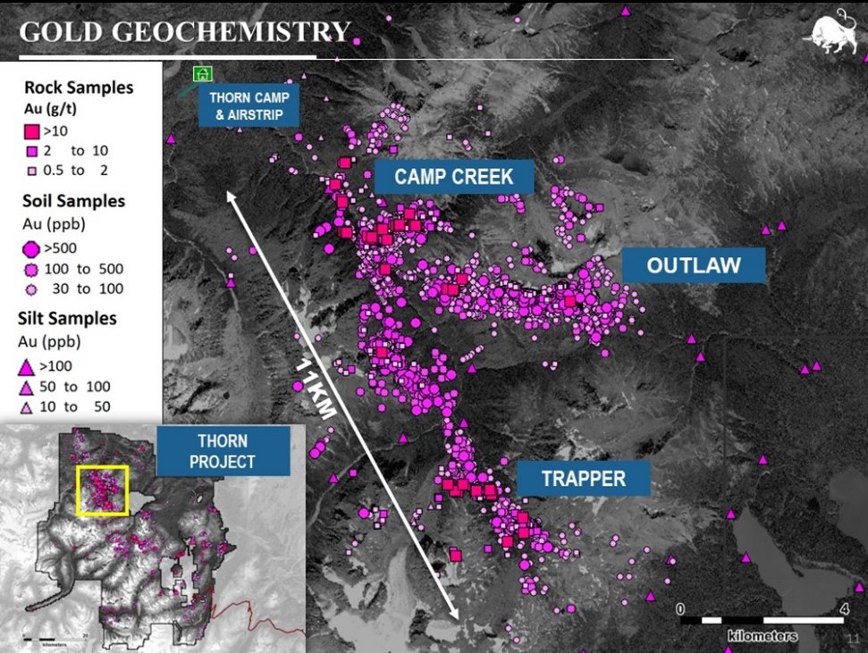
Table 1. Select Mineralized Intervals for the Trapper Target Drilling.
| Hole ID | From (m) | To (m) | interval (m) | Au (g/t) |
| THN22-237 | 4.00 | 308.46 | 304.46 | 1.19 |
| including | 88.00 | 196.00 | 108.00 | 2.62 |
| including | 112.00 | 196.00 | 84.00 | 3.10 |
| including | 155.00 | 169.00 | 14.00 | 10.70 |
| THN22-243 | 8.00 | 406.30 | 398.30 | 0.85 |
| including | 65.00 | 324.50 | 259.50 | 1.21 |
| including | 99.43 | 213.00 | 113.57 | 2.10 |
| including | 76.00 | 108.00 | 32.00 | 4.72 |
| including | 99.43 | 106.00 | 6.57 | 20.71 |
| including | 100.76 | 104.96 | 4.20 | 29.51 |
| THN22-248 | 18.00 | 217.00 | 199.00 | 1.12 |
| including | 130.00 | 217.00 | 87.00 | 2.19 |
| including | 188.00 | 214.00 | 26.00 | 3.43 |
| including | 188.00 | 197.00 | 9.00 | 7.31 |
| including | 188.00 | 191.00 | 3.00 | 17.15 |
All assay values are uncut weighted averages and intervals reflect drilled lengths as further drilling is required to determine the true widths of the mineralization.
The 2022 drill program at the Thorn Project included 58 holes for 18,200m of drilling across 4 target areas, with most of the drilling at the Camp Creek Copper dominant porphyry, the Trapper Gold Target, and to a lesser extent the Outlaw Gold Target and the Metla Copper-Gold Target. A total of 41 holes were drilled at the Trapper Gold target for 9,119m of drilling. Assays are pending for the remaining 9 drill holes and will be released as they become available.
Figure 2. Collar Locations and Drill Traces at the Trapper Target.

Discussion
Gold mineralization at Trapper is structurally controlled, and northwest, east-west and northeast trends have been identified. Mineralization appears to favour the contact between the Cretaceous (85.2 +/- 1.2Ma) quartz diorite and the Triassic lapilli tuff volcanic rocks with broad gold intervals largely hosted within the quartz diorite unit. The gold is associated with silver and base metal veins as pyrite-galena-sphalerite +/- chalcopyrite +/- bornite. With the use of oriented core measurements, surface mapping, geochemistry and magnetics, the aim is to achieve predictability of the gold-bearing zones. The current drilling at the Trapper Target is located about 7km southeast from the Camp Creek Copper Porphyry Target. The Trapper Target at surface is expressed as a 4km northwest trending gold and zinc soil geochemical anomaly which is part of the larger 11km gold geochemical anomaly as seen in Figure 1.
The 2022 Phase 2 drill campaign at Trapper was designed to test the southern and eastern extensions of the main mineralized trend previously identified in 2021 and early 2022. Step-out drilling was planned through a combination of mapping, oriented core data, and soil geochemistry, where soil samples collected during the 2022 field season extended the gold and zinc soil anomaly to the south and east. Results from the 2022 drill program continue to demonstrate the potential for broad intercepts of near surface gold mineralization which remains open in all directions.
Figure 3. Cross Section of the Reported Gold intercepts, Trapper Gold Target, Southwest View.
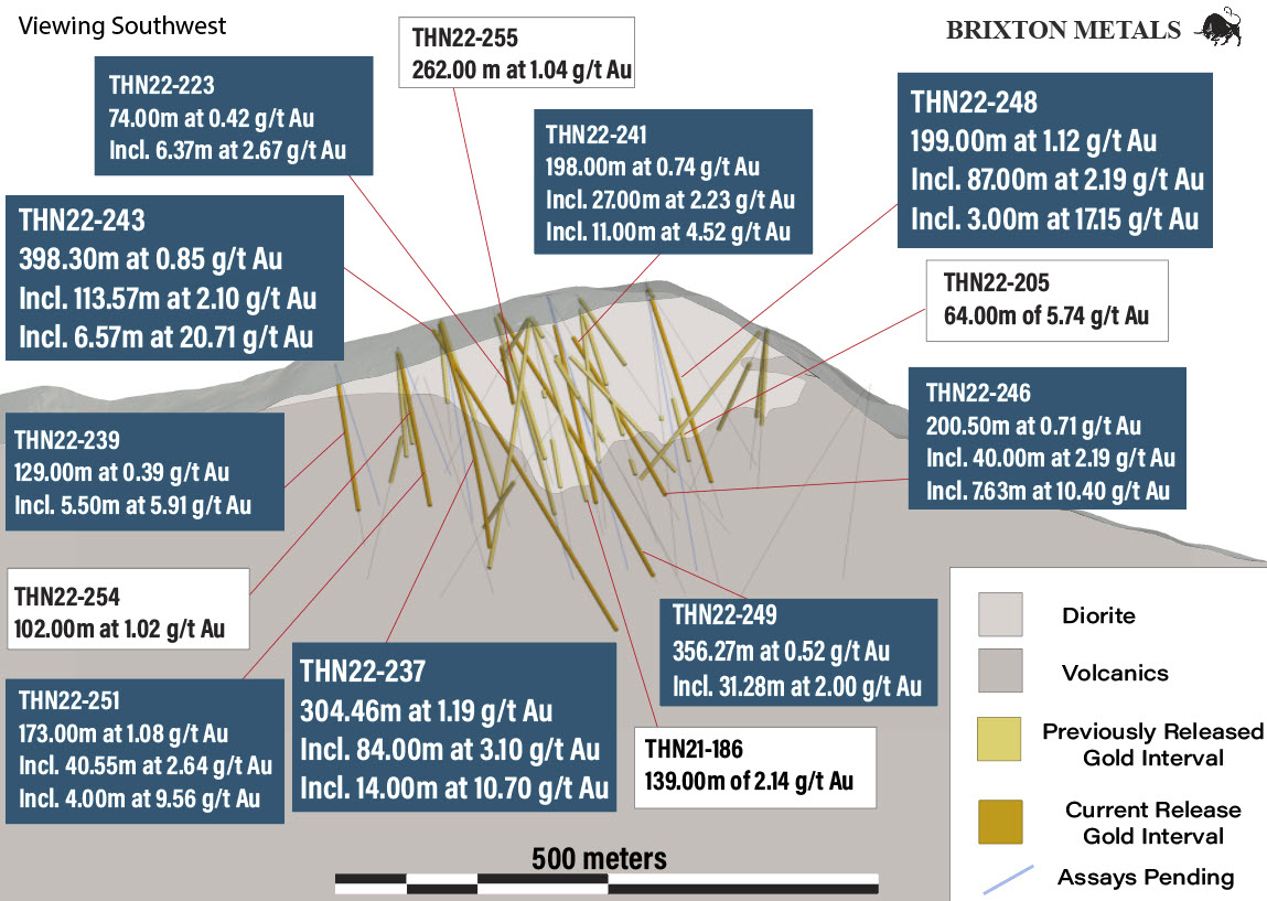
Drill holes THN22-237 and THN22-243 were drilled from the same pad location as previously released holes THN22-245 and THN22-247 which were planned as part of a series of southern step-outs from the previously identified mineralized trend to the north. Drilling targeted broader intervals of quartz diorite and the contact with the lapilli tuff which have been identified as favorable hosts for gold-bearing mineralized structures at Trapper. Both holes collared from the south into quartz diorite where intervals of base metal sulphide veins containing visible gold (Figures 4 to 7) were observed resulting in significant broad intercepts of gold mineralization. THN22-237 drilled at an azimuth of 27 degrees and assayed 304.46m of 1.19 g/t Au, including 108.00m of 2.62 g/t Au, and including 84.00m of 3.10 g/t Au, and including 14.00m of 10.70 g/t Au. THN22-243 was drilled at an azimuth of 7 degrees and assayed 398.30m of 0.85 g/t Au, including 113.57m of 2.10 g/t Au, and including 32.00m of 4.72 g/t Au, and including 4.20m of 29.51 g/t Au.
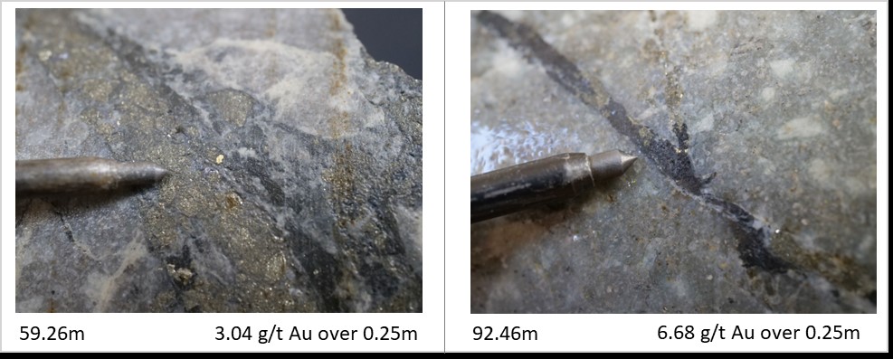
THN22-248 was collared off the same pad location as previously released hole THN22-205, which intercepted 64.00m of 5.74 g/t Au. Hole 248 drilled to the north above THN22-205 to better define the vertical extents of gold mineralization and intercepted 199.00m of 1.12 g/t Au, including 87.00m of 2.19 g/t Au, and including 9.00m of 7.31 g/t Au, and including 3.00m of 17.15 g/t Au.
Drill hole THN22-251 was drilled from the same pad as previously released holes THN22-257 and THN22-254 located 50m east of THN22-237. The pad location was planned to test the southeast extension of the projected diorite-lapilli tuff contact and the main mineralized trend interpreted from soil geochemistry and oriented drill core data. Hole 251 intercepted 173.00m of 1.08 g/t Au, including 40.55m of 2.64 g/t Au, and including 14.00m of 3.63 g/t Au. Assays are pending for hole THN22-256 which was also drilled from this pad location.
Figure 4. Visible Gold Photographs of HQ core from hole THN22-237.
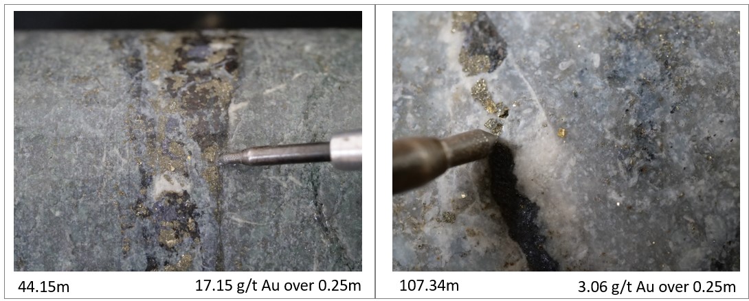
Figure 5. Visible Gold Photographs of HQ core from hole THN22-237.

Figure 6. Visible Gold Photographs of HQ core from hole THN22-243.
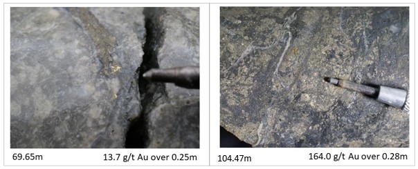
Figure 7. Visible Gold Photographs of HQ core from hole THN22-248.
THN22-249 was collared from the same pad location as previously released holes THN22-252 and THN22-255 as part of a series of southern step-outs from the previously identified mineralized trend. Hole 249 intercepted visible gold and base metal sulphide mineralization over a broad interval and assayed 0.52 g/t Au over 356.27m, including 71.00m of 1.32 g/t Au, and including 31.28m of 2.00 g/t Au.
THN22-246 and THN22-241 were collared from the same pad location approximately 100m southeast of previously released hole THN22-205. THN22-246 was drilled at an azimuth of 21 degrees and intercepted 200.50m of 0.71 g/t Au, including 113.13m of 1.11 g/t Au, and including 7.63m of 10.40 g/t Au. THN22-241 was drilled to the north with similar results assaying 0.74 g/t Au over 198.00m, including 113.00m of 1.05 g/t Au, and including 11.00m of 4.52 g/t Au. Two additional drill holes are pending assays from this pad location.
THN22-223 was drilled 40m east of previously released holes THN22-207 & THN21-186 to test the eastern extents of the mineralized trend. One additional hole is pending assays from this pad location. THN22-239 collared from the south and was drilled 120m southeast of THN22-237 to further test the trend of mineralization as well as the contact zone between the diorite and lapilli tuff. One additional hole is pending assays from this location. THN22-227 was drilled from the same location as previously released holes THN22-225 and THN22-226 targeting newly discovered surface mineralization identified during the 2022 prospecting program at Trapper.
Table 2. Additional Select Reported Mineralized Intervals for the Trapper Target Drilling.
| Hole ID | From (m) | To (m) | interval (m) | Au (g/t) |
| THN22-251 | 7.00 | 180.00 | 173.00 | 1.08 |
| including | 15.00 | 55.55 | 40.55 | 2.64 |
| including | 36.00 | 50.00 | 14.00 | 3.63 |
| including | 36.00 | 40.00 | 4.00 | 9.56 |
| including | 116.00 | 146.00 | 30.00 | 1.73 |
| THN22-249 | 3.85 | 360.12 | 356.27 | 0.52 |
| including | 160.00 | 231.00 | 71.00 | 1.32 |
| including | 162.00 | 193.28 | 31.28 | 2.00 |
| THN22-246 | 33.00 | 233.50 | 200.50 | 0.71 |
| including | 88.00 | 201.13 | 113.13 | 1.11 |
| including | 193.50 | 233.50 | 40.00 | 2.19 |
| including | 193.50 | 201.13 | 7.63 | 10.40 |
| including | 198.00 | 200.71 | 2.71 | 23.18 |
Table 3. Additional Select Reported Mineralized Intervals for the Trapper Target Drilling.
| Hole ID | From (m) | To (m) | interval (m) | Au (g/t) |
| THN22-241 | 53.00 | 251.00 | 198.00 | 0.74 |
| including | 138.00 | 251.00 | 113.00 | 1.05 |
| including | 162.00 | 189.00 | 27.00 | 2.23 |
| including | 175.00 | 186.00 | 11.00 | 4.52 |
| THN22-223 | 14.00 | 88.00 | 74.00 | 0.42 |
| including | 17.00 | 45.37 | 28.37 | 0.82 |
| including | 39.00 | 45.37 | 6.37 | 2.67 |
| THN22-239 | 22.00 | 151.00 | 129.00 | 0.39 |
| including | 47.50 | 86.00 | 38.50 | 0.99 |
| including | 75.50 | 81.00 | 5.50 | 5.91 |
| THN22-227 | 22.00 | 43.00 | 21.00 | 0.11 |
All assay values are uncut weighted averages and intervals reflect drilled lengths as further drilling is required to determine the true widths of the mineralization.
About the Trapper Gold Target
The geochemical footprint for the Trapper Gold Target was expanded in 2021 to 4km by 1.5km. The gold-in-soil geochemical signature has a strong positive correlation to zinc and lead. The Trapper Target represents a volcanic and intrusive hosted gold target. The volcanics are Triassic Stuhini lapilli tuff and at least two intrusive phases have been identified as diorite and quartz diorite. Age-dating for the mineralized intrusive is Cretaceous of 85.2Ma +- 1.2Ma. Visible gold has been identified in core and surface outcrops across the Trapper Target area. Rock grab samples have returned up to 135 g/t Au. Visible gold is recognized in several environments: within base metal-veins-veinlets (sphalerite-galena-pyrite-chalcopyrite), quartz-stockwork, sulphosalt-pyrite veinlets, and disseminated gold in the diorite. In 2022, Brixton drilled 9,119m. In 2021, Brixton drilled 3107m. In 2011, forty-two drill holes were completed by a previous operator, totaling 8581m, where drill hole TG11-11 returned 32.64m of 1.78 g/t Au including 0.41m of 92.8 g/t Au with visible gold. The Trapper Target is royalty free.
Drilling Information
Table 4. Drill Collar and Hole Information of Current News Release.
| Thorn Drill Holes: This Release | ||||||||
| Hole ID | Easting | Northing | Elevation (m) | Azimuth | Dip | Depth | Zone | Status |
| THN22-223 | 630375 | 6485535 | 1286 | 237 | -45 | 178.31 | Trapper | Current Release |
| THN22-227 | 630506 | 6485905 | 1132 | 20 | -49 | 76.20 | Trapper | Current Release |
| THN22-237 | 630351 | 6485431 | 1301 | 27 | -45 | 308.46 | Trapper | Current Release |
| THN22-239 | 630458 | 6485404 | 1261 | 22 | -66 | 188.36 | Trapper | Current Release |
| THN22-241 | 630257 | 6485477 | 1324 | 3 | -47 | 282.55 | Trapper | Current Release |
| THN22-243 | 630352 | 6485419 | 1297 | 7 | -45 | 406.30 | Trapper | Current Release |
| THN22-246 | 630258 | 6485477 | 1324 | 21 | -56 | 270.36 | Trapper | Current Release |
| THN22-248 | 630221 | 6485569 | 1336 | 353 | -58 | 257.25 | Trapper | Current Release |
| THN22-249 | 630302 | 6485457 | 1310 | 5 | -45 | 370.94 | Trapper | Current Release |
| THN22-251 | 630410 | 6485437 | 1276 | 26 | -55 | 180.91 | Trapper | Current Release |
| Total Meters | 2,519.64 | |||||||
Table 5. Drill Collar and Hole Information of Previously Reported Results.
| Thorn Drill Holes: Previously Released | ||||||||
| Hole ID | Easting | Northing | Elevation (m) | Azimuth | Dip | Depth | Zone | Status |
| THN22-200 | 627774 | 6491687 | 619 | 241 | -69 | 629.02 | Camp Creek | Reported July 6, 2022 |
| THN22-201 | 627871 | 6491942 | 670 | 239 | -83 | 1302.71 | Camp Creek | Reported August 16, 2022 |
| THN22-202 | 627774 | 6491690 | 613 | 290 | -76 | 636.12 | Camp Creek | Reported December 20, 2022 |
| THN22-203 | 630221 | 6485567 | 1336 | 6 | -44 | 242.93 | Trapper | Reported July 6, 2022 |
| THN22-204 | 630222 | 6485571 | 1340 | 7 | -80 | 282.55 | Trapper | Reported July 6, 2022 |
| THN22-205 | 630222 | 6485567 | 1332 | 7 | -67 | 303.89 | Trapper | Reported July 6, 2022 |
| THN22-206 | 630339 | 6485539 | 1305 | 0 | -50 | 338.02 | Trapper | Reported August 31, 2022 |
| THN22-207 | 630339 | 6485539 | 1305 | 0 | -76 | 232.26 | Trapper | Reported August 31, 2022 |
| THN22-208 | 630288 | 6485547 | 1326 | 1 | -64 | 258.47 | Trapper | Reported August 31, 2022 |
| THN22-209 | 630287 | 6485550 | 1321 | 1 | -80 | 218.54 | Trapper | Reported August 31, 2022 |
| THN22-210 | 630288 | 6485548 | 1325 | 3 | -44 | 160.62 | Trapper | Reported December 20, 2022 |
| THN22-211 | 629439 | 6486984 | 913 | 193 | -71 | 496.47 | Nemo | Reported December 20, 2022 |
| THN22-212 | 633059 | 6490359 | 1589 | 189 | -58 | 363.00 | Outlaw | Reported December 20, 2022 |
| THN22-214 | 633058 | 6490360 | 1588 | 180 | -83 | 378.00 | Outlaw | Reported December 20, 2022 |
| THN22-215 | 632153 | 6490361 | 1857 | 200 | -79 | 296.75 | Outlaw | Reported December 20, 2022 |
| THN22-216 | 630191 | 6485699 | 1295 | 189 | -52 | 200.50 | Trapper | Reported December 20, 2022 |
| THN22-217 | 630191 | 6485699 | 1295 | 214 | -55 | 163.14 | Trapper | Reported December 20, 2022 |
| THN22-218 | 630191 | 6485699 | 1295 | 215 | -70 | 163.07 | Trapper | Reported December 20, 2022 |
| THN22-219 | 630194 | 6485700 | 1296 | 138 | -51 | 184.40 | Trapper | Reported December 20, 2022 |
| THN22-224 | 629950 | 6485528 | 1278 | 136 | -45 | 86.87 | Trapper | Reported December 20, 2022 |
| THN22-225 | 630505 | 6485896 | 1112 | 99 | -54 | 106.61 | Trapper | Reported December 20, 2022 |
| THN22-226 | 630507 | 6485900 | 1132 | 127 | -65 | 135.03 | Trapper | Reported December 20, 2022 |
| THN22-245 | 630349 | 6485430 | 1303 | 8 | -60 | 223.42 | Trapper | Reported December 20, 2022 |
| THN22-247 | 630349 | 6485430 | 1301 | 7 | -81 | 114.60 | Trapper | Reported December 20, 2022 |
| THN22-252 | 630302 | 6485457 | 1310 | 2 | -63 | 182.27 | Trapper | Reported December 20, 2022 |
| THN22-254 | 630410 | 6485436 | 1276 | 26 | -76 | 108.50 | Trapper | Reported December 20, 2022 |
| THN22-255 | 630303 | 6485455 | 1316 | 26 | -44 | 331.01 | Trapper | Reported December 20, 2022 |
| THN22-257 | 630410 | 6485436 | 1276 | 5 | -76 | 93.57 | Trapper | Reported December 20, 2022 |
| THN22-213 | 627659 | 6491855 | 626 | 320 | -85 | 1243.00 | Camp Creek | Reported January 4, 2023 |
| THN22-231 | 627863 | 6492224 | 772 | 350 | -87 | 1297.58 | Camp Creek | Reported January 4, 2023 |
| Total Meters | 10,772.92 | |||||||
Quality Assurance & Quality Control
Quality assurance and quality control protocols for drill core sampling was developed by Brixton. Core samples were mostly taken at 1.0m intervals. Blank, duplicate (lab pulp) and certified reference materials were inserted into the sample stream for at least every 20 drill core samples. Core samples were cut in half, bagged, zip-tied and sent directly to ALS Minerals preparation facility in Whitehorse, Yukon. Some shipments were re-directed to the ALS preparation facility in Winnipeg to improve assay turn around time. ALS Minerals Laboratories is registered to ISO 9001:2008 and ISO 17025 accreditations for laboratory procedures. Samples were analyzed at ALS Laboratory Facilities in North Vancouver, British Columbia for gold by fire assay with an atomic absorption finish, whereas Ag, Pb, Cu and Zn and 48 additional elements were analyzed using four acid digestion with an ICP-MS finish. Over limits for gold were analyzed using fire assay and gravimetric finish. The standards, certified reference materials, were acquired from CDN Resource Laboratories Ltd., of Langley, British Columbia and the standards inserted varied depending on the type and abundance of mineralization visually observed in the primary sample. Blank material used consisted of non-mineralized siliceous landscaping rock. A copy of the QAQC protocols can be viewed at the Company’s website.
About the Thorn Project
The wholly-owned 2,900 square kilometer Thorn Project is located in British Columbia, Canada, approximately 90 km northeast of Juneau, AK. The southern limit of the Thorn claim boundary is roughly 50 km from tide water. The Thorn Project hosts a district-scale 80km trend of Triassic to Eocene, volcano-plutonic complex and related sedimentary units with several styles of mineralization related to porphyry and epithermal environments. Fourteen large-scale copper-gold targets have been identified for further exploration work. Information on each of the targets may be found at the following link: https://brixtonmetals.com/thorn-gold-copper-silver-project/
Qualified Person
Mr. Corey A. James, P.Geo., is a Senior Project Geologist for the company and a qualified person as defined by National Instrument 43-101. Mr. James has verified the data disclosed in this press release, including the sampling, analytical and test data underlying the information and has approved the technical information in this press release.
About Brixton Metals Corporation
Brixton Metals is a Canadian exploration company focused on the advancement of its mining projects toward feasibility. Brixton wholly owns four exploration projects: Brixton’s flagship Thorn copper-gold-silver-molybdenum Project, the Atlin Goldfields Projects located in NW BC (now under Option to Pacific Bay Minerals, the Langis-HudBay silver-cobalt-nickel Project in Ontario, and the Hog Heaven copper-silver-gold Project in NW Montana, USA (under option to Ivanhoe Electric Inc.). Brixton Metals Corporation shares trade on the TSX-V under the ticker symbol BBB, and on the OTCQB under the ticker symbol BBBXF. For more information about Brixton, please visit our website at www.brixtonmetals.com.
On Behalf of the Board of Directors
Mr. Gary R. Thompson, Chairman and CEO
Tel: 604-630-9707 or email: info@brixtonmetals.com
For Investor Relations, please contact:
Neil MacRae, Investor Relations
Tel: 604-630-9707 or email: neil.macrae@brixtonmetals.com
Neither the TSX Venture Exchange nor its Regulation Services Provider (as that term is defined in the policies of the TSX Venture Exchange) accepts responsibility for the adequacy or accuracy of this release.
Information set forth in this news release may involve forward-looking statements under applicable securities laws. Forward-looking statements are statements that relate to future, not past, events. In this context, forward-looking statements often address expected future business and financial performance, and often contain words such as “anticipate”, “believe”, “plan”, “estimate”, “expect”, and “intend”, statements that an action or event “may”, “might”, “could”, “should”, or “will” be taken or occur, including statements that address potential quantity and/or grade of minerals, potential size and expansion of a mineralized zone, proposed timing of exploration and development plans, or other similar expressions. All statements, other than statements of historical fact included herein including, without limitation, statements regarding the use of proceeds. By their nature, forward-looking statements involve known and unknown risks, uncertainties and other factors which may cause our actual results, performance or achievements, or other future events, to be materially different from any future results, performance or achievements expressed or implied by such forward-looking statements. Such factors include, among others, the following risks: the need for additional financing; operational risks associated with mineral exploration; fluctuations in commodity prices; title matters; and the additional risks identified in the annual information form of the Company or other reports and filings with the TSXV and applicable Canadian securities regulators. Forward-looking statements are made based on management’s beliefs, estimates and opinions on the date that statements are made and the Company undertakes no obligation to update forward-looking statements if these beliefs, estimates and opinions or other circumstances should change, except as required by applicable securities laws. Investors are cautioned against attributing undue certainty to forward-looking statements.