
Paramount gold NEVADA’s PFS drilling at grassy mountain project continues to confirm high grade gold mineralization For A PROPOSED underground mine

Drill Hole GM17-10 returns 38.7 meters grading 10.3 g/T of Au and 6.6 g/T of Ag within a 93.6 meters intercept grading 5.06 g/T gold and 8.74 g/T silver including 2ft.(0.6meters) grading 339 Au g/T (>9 oz)
Paramount Gold Nevada Corp. (NYSE MKT: PZG) announced today that ongoing drilling at its Grassy Mountain Gold Project in Eastern Oregon continues to intersect the underground core of the deposit with high gold grades. Results from four new holes verify the high-grade gold material for the proposed underground mine plan with expected variability.
The current 30-hole drill program is part of a Preliminary Feasibility Study (“PFS”) which Paramount is undertaking for construction and operation of an underground mine to exploit the high-grade gold core at Grassy Mountain. The PFS is expected to: convert, a significant portion of the measured plus indicated resources to proven and probable reserves; establish the parameters of a mining and milling operation; define capital and operating costs; and advance the project through permitting process with the Bureau of Land Management (“BLM”), Oregon Department of Geology and Mineral Industries (“DOGAMI”) and local agencies of Malheur County. The drilling is designed to: improve the confidence level of the resource; better define the high-grade core; and acquire material for additional metallurgical testing and geotechnical data required to determine precious metal recovery processes and mining method. The PFS is scheduled for completion in early 2018.
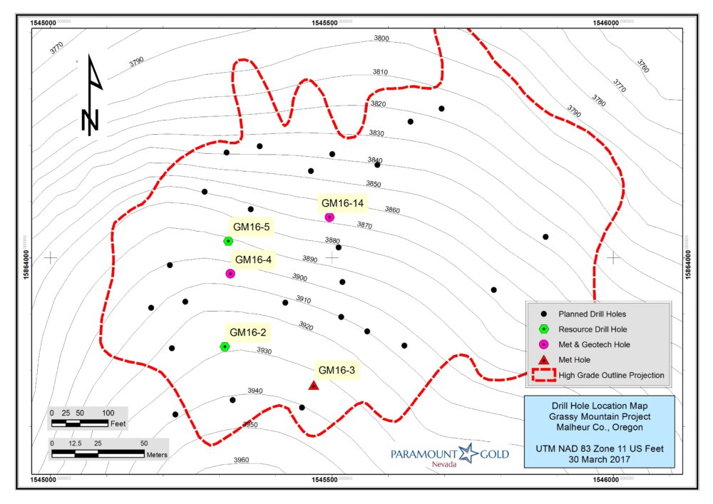
The four holes reported today were drilled within a 400ft. by 200 ft. area located on the south western edge of the high-grade core zone (see map below). GM17-10 successfully intersected the high-grade zone, confirming its continuity and extending it to the south west. GM17-10 returned 38.7 meters grading 10.3 g/T of Au and 6.6 g/T of Ag. GM16-06 intersected 29 meters grading 3.37 g/T of Au, helping to define the outer edge of the high-grade zone and improving our understanding of the controls on gold deposition. Drill holes GM17-07 and GM16-09 intersected 144 meters grading 1.25 g/T of Au (including 19.7 meters grading 2.31 g/T of Au) and 160 meters grading 1.28 g/T of Au (including 14.3 meters grading 3.14 g/T of Au) respectively (see all previously reported Grassy Mountain results).
Drilling was completed using a reverse circulation (“RC”) rig for the upper portion of the deposit and a core rig for the high-grade portion which will be incorporated into an underground mine plan. The table immediately below provides detailed objectives and observations for each drill hole. The second table below summarizes assay results for key intercepts.
ID |
Purpose |
Total depth (ft.) |
Total depth (m) |
Azimuth |
Dip |
Objectives |
Observations |
GM16-06 |
Metallurgical & Resource |
740 |
225.6 |
n/a |
-90 |
Met hole to acquire various rock types for related grade distribution. Also assess for lateral extension of high-grade zone |
Wide intercept grading over 3 g/T Aucould expand mineable resource |
GM17-07 |
Resource |
850.5 |
259.2 |
310 |
-77 |
Infill & resource confirmation drill hole |
Intersected similar mineralization as adjacent drill holes, confirming continuity |
GM16-09 |
Resource |
795 |
242.3 |
n/a |
-90 |
Infill drill hole designed to fill 200 ft. gap between existing holes |
Intersected similar grade as adjacent holes, proving continuity |
GM17-10 |
Resource |
822 |
250.5 |
342 |
-79 |
Resource confirmation drill hole using core between existing RC holes |
Wider than expected high-grade intercepts prove continuity. |
Hole ID |
Type |
From (ft.) |
To(ft.) |
Width (ft.) |
Width (m) |
Au(g/T) |
Ag(g/T) |
|
GM16-6 |
Core & RC |
185 |
695 |
510 |
155.4 |
1.63 |
8.0 |
|
Including |
305 |
380 |
75 |
22.9 |
1.52 |
10.9 |
||
Including |
395 |
437 |
42 |
12.8 |
2.32 |
17.5 |
||
Including |
471 |
617 |
146 |
44.5 |
2.67 |
10.5 |
||
Including |
520 |
617 |
97 |
29.6 |
3.37 |
10.5 |
||
GM17-7 |
Core & RC |
300 |
774 |
474 |
144.5 |
1.25 |
5.1 |
|
Including |
439 |
486 |
47 |
14.3 |
1.04 |
3.5 |
||
Including |
524 |
540 |
16 |
4.9 |
2.69 |
17.7 |
||
Including |
551.5 |
616 |
64.5 |
19.7 |
2.31 |
6.9 |
||
Including |
651 |
690 |
39 |
11.9 |
1.92 |
8.9 |
||
GM16-9 |
Core & RC |
225 |
750 |
525 |
160.0 |
1.28 |
6.4 |
|
Including |
555 |
596 |
41 |
12.5 |
2.72 |
14.2 |
||
Including |
632 |
679 |
47 |
14.3 |
3.14 |
7.1 |
||
GM17-10 |
Core & RC |
130 |
767 |
637 |
194.2 |
2.74 |
6.3 |
|
Including |
460 |
767 |
307 |
93.6 |
5.06 |
8.7 |
||
Including |
640 |
767 |
127 |
38.7 |
10.30 |
6.6 |
||
Including |
747 |
749 |
2 |
0.61 |
339.00 |
35.2 |
*Intercepts are calculated using uncapped Au assays. Intercepts are believed to be approximate true width of mineralization except for some small very high grade intercepts that show a lower angle to the core.
Paramount CEO, Glen Van Treek commented: “Drilling continues to confirm the high-grade core of the deposit and a large surrounding envelope of lower grade mineralization, some of which could ultimately be included in the mine plan. Once the drilling is completed, we will commence the resource definition and underground mine design. Depending upon the economics of mining and processing, we believe that the results of current drilling will convert significant resources to reserves. The PFS will evaluate several processing outputs, ensuring we select the most economically viable alternative.”
Results from nine holes have now been released. A total of 30 holes are planned in the current program. Resource and metallurgical drilling is expected to be completed in June. To date, the upper portion of 25 holes have been drilled using RC drill rigs with five more RC holes remaining to be drilled. Of the 25 RC holes, 22 have been completed with the deeper core drilling, leaving eight more core drill holes to be completed. Core samples from five holes are in the ALS Laboratories in Reno, Nevada for assaying.
Prefeasibility Update
Prefeasibility work is continuing on all aspects of the project. Recently, Paramount presented to the DOGAMI additional information outlining modifications to the mine access road and the additional areas required for mine facilities. To support access road design, and additional base line data collection, Paramount’s consultant, TCI Corp, recently completed a drone survey, taking over 14,000 high resolution pictures that are now being processed.
Piezometer installation on selected drill holes has been initiated to define water dynamics and prepare a hydrological model.
Paramount expects to submit a final Plan of Operation to the BLM in the third quarter which will trigger the initiation of the Environmental Impact Statement (EIS) by BLM and its selected consulting firm.
NI 43-101 Disclosure
Exploration activities at Grassy Mountain are being conducted by Calico Resources USA Corp. (a 100% owned subsidiary of Paramount Gold Nevada Corp.) personnel under the supervision of Michael McGinnis, Project Manager and a Qualified Person under National Instrument 43-101, who has reviewed and approved this release. An ongoing quality control/quality assurance protocol is being employed for the program including blank, duplicate and reference standards in every batch of assays.
Paramount Gold Nevada Corp.
Glen Van Treek, President, CEO and Director
Christos Theodossiou, Director of Corporate Communications
866-481-2233
Follow us on twitter: @ParamountNV