
VR intersects 243 m @ 1% TREO, including 15 m @ 2.14%, to discover the broadest and highest grade critical metal mineralization to date at Hecla Kilmer.
VR Resources Ltd. (TSX.V: VRR, FSE: 5VR; OTCQB: VRRCF), the “Company“, or “VR”, announces the broadest and strongest intersection to date of high grade rare earth elements (REE’s) and critical metals in Hole 13 from its Hecla-Kilmer (“H-K”) property located in northern Ontario.
- 243 metres @ 1.01% TREO, of which 19% are PMREO*, within 290 metres @ 0.91% TREO starting at surface and continuous from top to bottom in Hole HK22-013, and including:
- 65 metres at 1.66% TREO, starting at 155 metres, and including:
- 39 metres @ 2.01% TREO starting at 155 metres, and;
- 15 metres @ 2.14% TREO starting at 311 metres.
- The 65 metre interval of 1.66% TREO is made up of 24% PMREO;
- The 15 metre interval with 2.14% TREO contains 71% P2O5.
- 65 metres at 1.66% TREO, starting at 155 metres, and including:
* PMREO: sum of the high value rare earth oxides Pr2O3 + Nd203 + Tb2O3 + Dy2O3 used in permanent magnets for wind turbines
and electric vehicles. PMREO % is the PMREO sum divided by TREO (total rare earth oxide), and expressed as a percent.
Of importance towards the economic potential of this discovery:
- Depth: Mineralization comes to bedrock surface at the base of till (44 metres; overburden);
- Continuous mineralization in potassic alteration over the entire 287 metre vertical hole;
- Open to depth, with no geological limits such as vertical zonation in alteration or mineralization; similar mineralization spans more than 500 vertical metres between the top of Drill Hole 004 and the bottom of Drill Hole 002 (see Figure 1);
- Strike length potential exceeds 1,000 metres along the east-west structure which controls mineralization (see magnetic map and 3D inversion isoshells in Figure 1);
- Infrastructure: this drill hole is located 23 km northwest of the active Ontario Northern Railroad, Provincial Highway 634, and provincial grid power at the Otter Rapids hydro-electricity facility.
Data are expected imminently for Hole 14, and in the next two weeks for the remaining five holes.
Table 1. Summary of the broad intersections of Critical Metals made to date at Hecla-Kilmer.
Figure 1. Plan map with the location of all 17 drill holes now completed in the first three drill programs at Hecla-Kilmer, plotted on an RTP magnetic base map covering the entire complex.
Figure 2. Drill hole locations and key Critical Metal intersections in the northwestern portion of H-K, plotted on a 1VD magnetic map derived from the ultra- high resolution drone survey completed in 2022.
Drill core photos in Figure 3 and Figure 4 show alteration and mineralization textures in core intervals with assays of greater than 2% TREO. Protolith alkaline igneous rocks including nepheline syenite porphyry dykes are completely overprinted by potassic alteration dominated by hydrothermal biotite, magnetite and apatite. Critical metal mineralization is most commonly associated with sulfide-bearing fluorite-carbonate-apatite veins and carbonatite dykes (phoscorite and sovite), hosted in magnetite-biotite-amphibole rich fenite. Based on the QEMSCAN analysis of the mineralization at surface in Drill Hole 004, the REE’s are contained mainly in monazite, bastnaesite, and apatite.
Table 1: REE and Critical Metal Intersections, Hecla-Kilmer (Hole 13 are new data)
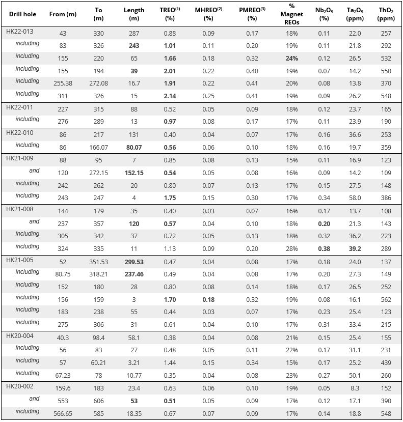
- TREO is the summation of Ce2O3 + La2O3 + Pr2O3 + Nd2O3 + Sm2O3 + Eu2O3 + Gd2O3 + Tb2O3 + Dy2O3 + Ho2O3 + Er2O3 + Tm2O3 + Yb2O3 + Lu2O3 + Y2O3.
- MHREO is the sum of the middle and heavy rare earth oxides (Sm2O3 + Eu2O3 + Gd2O3 + Tb2O3 + Dy2O3 + Ho2O3 + Er2O3 + Tm2O3 + Yb2O3 + Lu2O3 + Y2O3).
- PMREO is the sum of high value rare earth oxides used in permanent magnet motors and turbines used in electric vehicles and wind turbines (Pr2O3 + Nd203 + Tb2O3 + Dy2O3). The % Magnet REO column is this PMREO sum divided by TREO, and expressed as a percent.
From VR’s CEO, Dr. Michael Gunning, “This new intersection from top to bottom in Hole 13 confirms the economic potential of the REE and critical metal discovery made by VR within the polymetallic, hydrothermal vein and breccia system at Hecla-Kilmer in 2020.
What are the value metrics for a 291 metre intersection of rare earth elements. Figure 5 is provided for context. Firstly, the ratio of up to 24% PMREO at Hecla-Kilmer is high. That is important. The light and heavy REE’s Neodymium, Dysprosium, Terbium and Praseodymium are the most valuable because they are essential in the manufacturing of permanent magnets necessary for the electric vehicle and wind energy turbine industries. That demand-based value is amplified by scarcity; that is, PMREO’s are absent in most REE deposits globally. As such, and based solely on the presence of these four heavy rare earth elements, the 290 metre REE intersection in Hole 13 at Hecla-Kilmer has a value of $172/kg using exchange and index prices of today, which on face value is comparable to 4.3% copper, also at the current index price of today.
Second. What about the niobium? The value analogue above for the 290 metre REE intersection in Hole 13 does not include the 0.11% grade in niobium (Table 1). Further, drill holes 5 and 8 located to the west in the core of the gravity anomaly produced twice that grade over 299 and 120 metre intersections, respectively (see Figure 2). The niobium price has risen four-fold in the past decade, to the $45/kg level, reflecting in part a demand related to its role as a super-conductor to improve the performance of the afore-mentioned permanent magnets essential to the EV and wind turbine sectors. We will comment on the potential value-add of niobium to the REE discovery at H-K when we have data in hand for Hole 17.
Finally, how does Hole 13 compare with the grade metrics for REE deposits globally? Firstly, all ten of the top ten REE deposits in the world are IOCG breccia systems and/or evolved hydrothermal breccia systems in carbonatite, akin to the IOA-affinity hydrothermal breccia system and host multiphase carbonatite complex at Hecla-Kilmer. In that sense, the intersection in Hole 13 is in the same geological ballpark as most world-class REE mineral systems. Second, the 0.91 – 2.14% range in TREO content in the various intervals within the 290 metre intersection in Hole 13 is comparable to the range of 0.4 – 1.73% TREO reported for the average resource grades of eight of the top ten REE deposits globally. Further, the 1.01% average TREO grade in Hole 13 is maintained over 243 vertical metres and is open to depth, with no constraints to further depth extent such as vertical zonation in alteration or changes in mineralization.
VR has now confirmed REE and critical metal intersections in 8 of the 12 drill holes for which geochemical data have been received. Drilling is still at a very early stage at H-K, yet the 17 holes completed to date demonstrate the lateral and vertical breadth of the hydrothermal breccia and alteration system with critical metals. The economic potential of this discovery lies in the polymetallic nature of the intersections, the occurrence of the mineralization at surface, and its proximity to infrastructure.
This discovery contributes to the rapidly evolving critical metal strategies of governments across North America aimed at growing domestic EV and wind turbine sectors in order to sustain the growth of the green economy. This relevance underscores the potential value of H-K to our shareholders, and we look forward to providing further updates as we receive final data and commence exploration planning.”
Background
Hecla-Kilmer (“H-K”) is a large and multiphase alkaline intrusive complex with carbonatite. It is 4 – 6 km in size, Proterozoic in age, and was emplaced along the western margin of the crustal-scale Kapuskasing structural zone which bisects the Archean Superior Craton in northern Ontario.
A shallow, six-hole diamond drill program was completed in 1970 as part of a regional base metal exploration program by Ashland Oil and Elgin Petroleum. One hole was abandoned, and a scant 854 metres were completed in total in the other five holes, all on magnetic highs in the outer concentric zones of the complex. There is no record of drill core sampling or geochemical data. Selco Exploration Company completed two drill holes in 1981 on peripheral magnetic highs as part of a regional diamond exploration program; they intersected altered ultra-basic rocks and black breccia in the outer, concentric zones of the multiphase complex at H-K. After this historical drilling, a regional-scale airborne magnetic survey was completed in 1993 for diamond exploration; it provided high-resolution data covering the H-K complex.
The opportunity for VR is to be the first company to apply modern IOCG and carbonatite mineral deposit models to explore the multiphase H-K complex and hydrothermal breccia system as a whole, and to use new exploration technologies not previously available when the historic drilling was done.
VR completed the first airborne EM survey over H-K in June, 2020, using the state-of-the-art VTEM+ system of Geotech Ltd. Flown at 100 m line spacing over a 6 x 7 km survey block for a total of 450 line-km, the data provide a high resolution of detail. The Company also completed an independent, 3-D inversion of both magnetic and EM data, for improved modeling of the complex in three dimensions. A detailed, ground-based gravity survey covering an area of 1.5 x 3.5 km was completed in the winter season of 2021, with high-resolution data generated from 597 stations on an equant grid spacing of 100 m.
VR completed four drill holes for a total of 1,971 metres in October, 2020, targeting the northern MVI (magnetic inversion) anomaly at H-K. The Company followed up that drilling in October, 2021, with the completion of five additional holes for a total of 2,604 metres, targeting the high contrast, 3.5 mGal gravity anomaly that is co-spatial with, but slightly offset from the MVI anomaly.
From the second drill hole onwards, VR discovered a hydrothermal vein and breccia system extending from bedrock surface to 500 m depth and containing broad intersections from 50 to 299 metres long of critical metal mineralization throughout (REE + Nb), and elevated copper and gold locally. The intersections of fluorite-carbonate veins and hydrothermal breccia are pervaded by carbonatite dykes of sovite and phoscorite composition. The mineralization occurs within high temperature, sulfide-bearing, calc-potassic and potassic alteration dominated by assemblages of magnetite, biotite, amphibole and apatite which completely replace original alkaline host rocks such as ijolite and nepheline syenite, and a myriad of porphyry dyke phases.
A state-of-the-art, ultra-high resolution drone magnetic survey was completed in the fall of 2021, and expanded in March of 2022, in order to: 1. cover the entire complex at H-K, and; 2. identify vectors for how best to follow up on the hydrothermal breccia intersections with critical metals and gold in the first two drill programs. The final survey is 3.4 x 4.5 km in size, comprising 121 lines at both 25 and 50 m line-spacing for a total of 410 line-km. The survey produces a very high resolution of data because of the tight line spacing, the low “tree-top” flight altitude of just 30 metres above ground, and a computerized flight control paired with a new, very high sensitivity potassium-vapour magnetometer.
A third diamond drill program of eight additional holes totalling 2,751 m was completed in the spring of 2022. Broad intersections of critical metal mineralization are now confirmed in 11 of 17 holes completed to date, with data from five holes still pending. Alteration and mineralization extend from surface to more than 500 metres of vertical extent, related to a vertical hydrothermal vein and breccia system that is anchored to well-defined structures in the northwestern part of the multiphase complex at H-K.
Technical Information
Summary technical and geological information for the Company’s various exploration properties is available at the Company’s website at www.vrr.ca.
VR submitted all drill core samples for geochemical assay to the ALS Global Ltd. (“ALS”) laboratory facilities in Timmins, Ontario, with final geochemical analytical work done at the ALS laboratory located in North Vancouver, BC., including lithium borate fusion, ICP-MS and ICP-AES analyses for base metals, trace elements and full-suite REE analysis, and gold determination by atomic absorption on fire assay. Analytical results are subject to industry-standard and NI 43-101 compliant QAQC sample procedures externally by the Company and internally at the laboratory as described by ALS.
Technical information for this news release has been prepared in accordance with the Canadian regulatory requirements set out in National Instrument 43-101. Justin Daley, P.Geo., Exploration Manager and Chief Geologist at VR and a non-independent Qualified Person oversees and/or participates in all aspects of the Company’s mineral exploration projects, and the content of this news release has been reviewed on behalf of the Company by the CEO, Dr. Michael Gunning, P.Geo., a non-independent Qualified Person.
About the Hecla-Kilmer Property
The Hecla-Kilmer complex is located 23 km northwest of the Ontario hydro-electric facility at Otter Rapids, the Ontario Northland Railway, and the northern terminus of Highway 634 which links the region to the towns of Cochrane and Kapuskasing to the south, located on the northern Trans-Canada Highway.
The H-K property is large. It consists of 224 mineral claims in one contiguous block approximately 6 x 7 km in size and covering 4,617 hectares. The property is owned 100% by VR. There are no underlying annual lease payments on the property, nor are there any joint venture or back-in interests. There is an industry-standard royalty attached to the property, including a buy-back provision in favour of VR.
Like the Ranoke property, H-K is located on provincial crown land, with mineral rights administered by the Ontario Ministry of Northern Development, Mines, Natural Resources and Forestry (“MNDM”). There are no annual payments, but the MNDM requires certain annual exploration expenditures and reporting. The property falls within the traditional territories of the Moose Cree and Taykwa Tagamou First Nations.
About VR Resources
VR is an established junior exploration company focused on greenfields opportunities in copper, gold and critical metals (TSX.V: VRR; Frankfurt: 5VR; OTCQB: VRRCF). VR is the continuance of 4 years of active exploration in Nevada by a Vancouver-based private company. The diverse experience and proven track record of its Board in early-stage exploration, discovery and M&A is the foundation of VR. The Company focuses on underexplored, large-footprint mineral systems in the western United States and Canada. VR owns its properties outright and evaluates new opportunities on an ongoing basis, whether by staking or acquisition.
The Company continues its normal course of business in 2022 within the framework of modified exploration programs in response to the COVID-19 pandemic, with the goal of ensuring the health and safety of staff and project personnel.
ON BEHALF OF THE BOARD OF DIRECTORS:
“Michael H. Gunning”
____________________________
Dr. Michael H. Gunning, PhD, PGeo
President & CEO
For general information please use the following:
Website: www.vrr.ca
Email: info@vrr.ca
Phone: 604-262-1104
Forward Looking Statements
This press release contains forward-looking statements. Forward-looking statements are typically identified by words such as: believe, expect, anticipate, intend, estimate, postulate and similar expressions or those which, by their nature, refer to future events. Forward looking statements in this release include those related to the companies upcoming plans, such as “The potential of this discovery lies in the polymetallic nature of the intersections made to date, and the sheer lateral and vertical scale of the hydrothermal breccia system”, and “VR evaluates new opportunities on an ongoing basis, whether by staking or acquisition.”
This news release contains statements and/or information with respect to mineral properties and/or deposits which are adjacent to, and/or potentially similar to the Company’s mineral properties, but which the Company has no interest in nor rights to explore. Readers are cautioned that mineral deposits on similar properties are not necessarily indicative of mineral deposits on the Company’s properties.
Although the Company believes that the use of such statements is reasonable, there can be no assurance that such statements will prove to be accurate, and actual results and future events could differ materially from those anticipated in such statements. The Company cautions investors that any forward-looking statements by the Company are not guarantees of future performance, and that actual results may differ materially from those in forward-looking statements. Trading in the securities of the Company should be considered highly speculative. All of the Company’s public disclosure filings may be accessed via www.sedar.com and readers are urged to review these materials.
Neither the TSX Venture Exchange nor its Regulation Services Provider (as that term is defined in Policies of the TSX Venture Exchange) accepts responsibility for the adequacy or accuracy of this release.
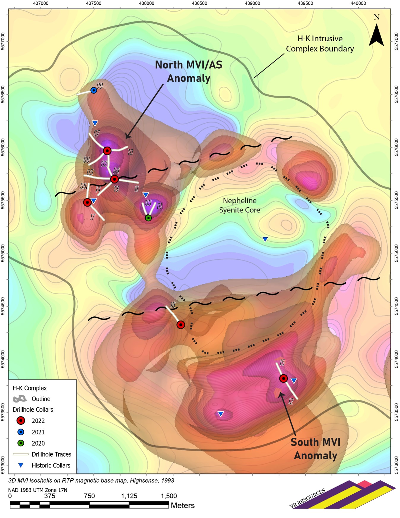
Figure 1. Drill hole locations relative to the outline of the overall multiphase intrusive complex at H-K, plotted on a contoured RTP magnetic base map with superimposed 3D isoshells from the MVI magnetic inversions.

Figure 2. Drill hole locations and key REE intersections in the northwestern portion of the H-K complex, plotted on the 1VD magnetic map derived from the ultra- high resolution drone magnetic survey completed in 2022. Note the strong correlation between vertical derivative magnetic boundaries and phoscorite veins and the development of potassic, fenite alteration.
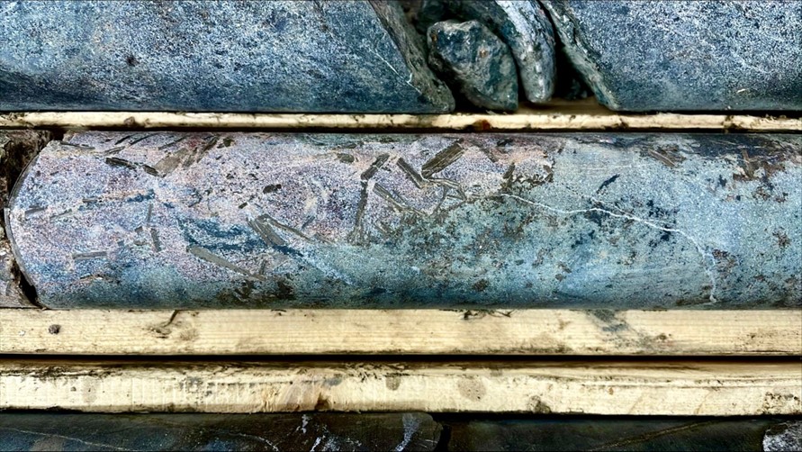
Figure 3. Photograph of drill core at 173m with 2.8% TREO in drill hole HK22-013. The pink area to left is high temperature, potassic alteration which displays elongate, quenched magnetite and biotite crystals in a pink matrix of apatite. The green area of calc-potassic alteration is quenched less, and includes amphibole together with euhedral magnetite and biotite crystals set in a green, apatite-rich matrix with carbonate and fluorite. Protolith alkaline igneous rocks including shonkonite and nepheline syenite porphyry dykes are completely overprinted and/or replaced.
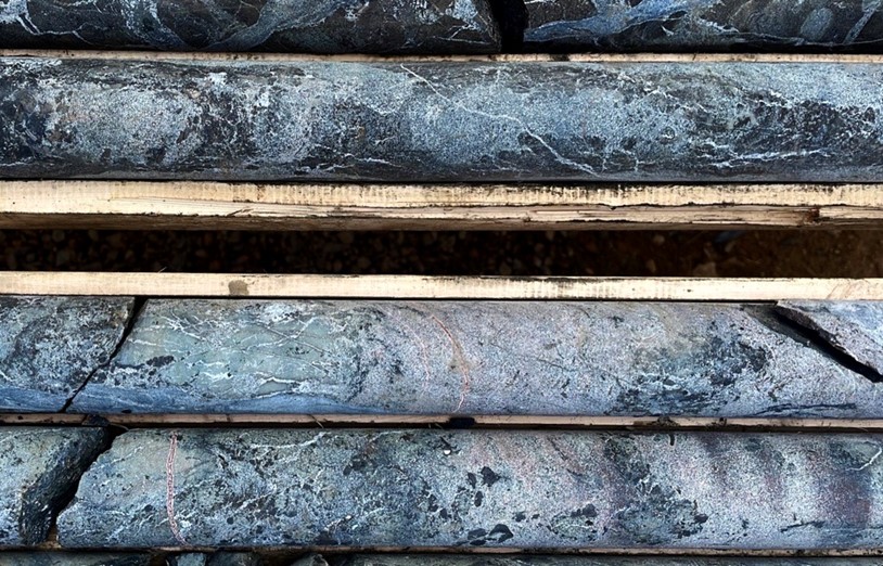
Figure 4. Photograph of drill core at 219m with 2.2% TREO and 19% P205 in drill hole HK22-013. Rare earth element mineralization is amongst a myriad of carbonatite dykes (phoscorite and sovite) which themselves are cut by fluorite-rich carbonate veins. Protoloith alkaline igneous rocks are completely replaced by a potassic alteration assemblage dominated by hydrothermal biotite floating in a fine-grained matrix mosaic of apatite and fluorite.
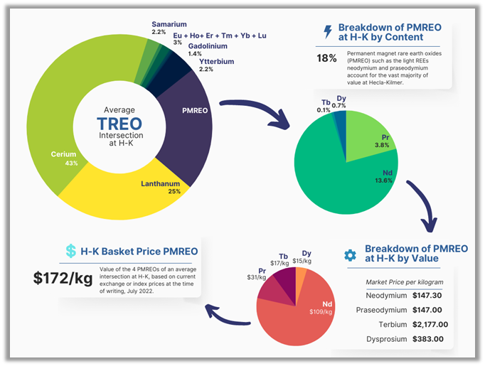
Figure 5. Schematic representation of the breakdown of the TREO data for an average rare earth element intersection at Hecla-Kilmer, the breakdown of the subset of rare earth oxides used in permanent magnets which are essential for electric vehicles and wind energy turbines, that is, the PMREO’s such as neodymium and praseodymium, and the resultant overall value per kilogram of an average REE intersection at H-K based solely on the current metal values of the PMREO’s.