
White Gold Corp. Outlines Significant Gold in Soil Anomalies and Completes Structural Geological Interpretation at the Bonanza Property, Yukon

White Gold Corp. (TSX.V: WGO, OTC: WHGOF, FRA: 29W) (the “Company“) is pleased to announce significant soil geochemistry results from 2020 sampling and completion of a new structural geological interpretation at its Bonanza property, which is located approximately 10 km south of Dawson City, Yukon. This work formed part of the Company’s 2020 exploration program backed by strategic partners Agnico Eagle Mines Limited (TSX: AEM, NYSE: AEM) and Kinross Gold Corp (TSX: K, NYSE: KGC) on its extensive 420,000 hectare land package in the prolific White Gold District, Yukon, Canada.
Highlights Include:
- The Bonanza property is situated in close proximity to the richest placer mining sites in the Yukon with over 5 Moz of gold produced to date.
- Infill soil geochemistry sampling has outlined multiple property-scale linear WNW- to NW-trending gold in soil anomalies.
- A new structural geological interpretation based on airborne magnetics and electromagnetics (EM), and high-resolution drone LiDAR data, has significantly improved the understanding of structural controls on gold mineralization.
- The combined strike length of the multiple gold in soil anomalies and interpreted controlling structures is more than 6km kilometers and remains untested by trenching and/or drilling.
- These results will be combined with historic data over the coming months to define targets for drilling later in the year.
- A video overview from management discussing the Bonanza property, 2020 results and future plans can be found at: https://www.youtube.com/watch?v=XViwbru0AoY
Shawn Ryan, Chief Technical Advisor of the Company commented, “In 2004 when I first staked the Bonanza property, I was struck by the lack of exploration in an area that had been the epicentre for the Klondike Gold Rush and had produced so much placer gold”. “Back then I was intrigued by the new GSC airborne magnetic survey maps indicating a distinct north-south trending magnetic lineament that I felt could represent an important mineralizing structure. Since then, we have carried out intermittent exploration on the property but only this past year with a larger soil sampling program, adding 3,645 samples to the database, combined with magnetics and LiDAR have we been able to clearly see property-scale linear trending gold anomalies correlating perfectly with Matias Sanchez’s structural interpretation of the property. His interpretation work clearly indicates a fault system, which just so happens to be anomalous in gold and all ironically trending towards Bonanza Creek. Â Â I always felt with so much placer gold in Bonanza Creek, there could be a few potential sources. With Klondike Gold Corp.’s Lone Star zone to the south representing one potential source, we may be looking at another. This year we’ll continue to refine our interpretation and advance targets to the drill-ready stage for testing.”
Figures accompanying this news release can be found at: http://whitegoldcorp.ca/investors/exploration-highlights/
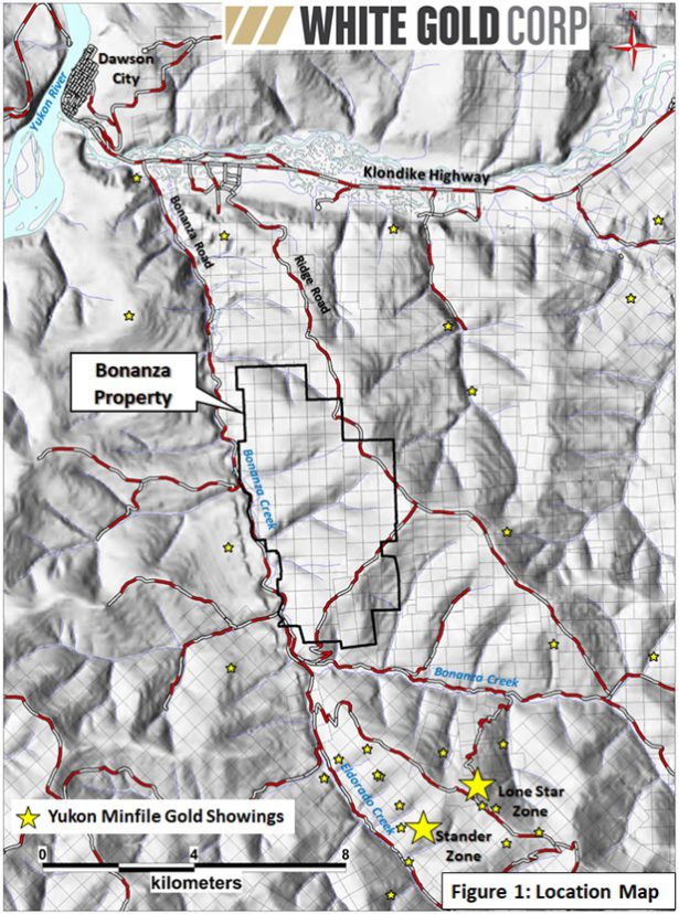
Bonanza Property
The Bonanza property covers an area of 2,250 hectares located immediately east of Bonanza Creek and 5 km north-northwest of Klondike Gold Corp.’s (TSX.V: KG, FRA: LBDP, OTC: KDKGF) Lone Star and Stander zones which are currently being advanced towards a maiden mineral resource estimate expected in 2022 (Figure 1). Bonanza Creek, and its main tributary Eldorado Creek to the south, were the most prolific placer gold producers in the historic Klondike Goldfields having collectively produced just over 25% (minimum 5.4 Moz) of the Klondike’s estimated 20 Moz of placer gold. Surprisingly, only limited exploration has been carried out on the Bonanza property in search of a potential bedrock source of the gold, or additional mineralization in the area.
The Bonanza property was originally staked in 2004 and since that time has seen intermittent exploration. From 2004 through 2019, exploration work included geological mapping and prospecting, soil geochemistry surveys (50m spaced samples on 100m spaced lines) and an airborne frequency domain EM and magnetic survey. More recent detailed exploration in 2017-2018 was restricted to short segments of anomalous gold in soil anomalies and included limited GT Probe soil-bedrock interface sampling (301 samples on 5 lines), IP-resistivity surveys (5 lines totalling 2 line km) and 5 rotary air blast (RAB) holes totaling 445m.
The geology of the Bonanza property is poorly known due to a lack of outcrop which is generally restricted to creeks and access roads. Based on current understanding, the northern and central portions of the property appear to be underlain by Late Permian quartz-feldspar augen schist, whereas the southern part of the property is dominated by rocks of the Klondike Schist. As described below, multiple interpreted faults are recognized on the property with steeply dipping WNW- and NW-trending faults being the most significant in terms of gold mineralization.
2020 Exploration Program
The 2020 exploration program included 159 line km of ground magnetics and VLF-EM surveys, and extensive infill soil geochemistry sampling at 25m spacings on 100m spaced survey lines, as well as extension of soil sampling in several other areas. A total of 3,645 soil samples were collected in 2020, bringing the total soil geochemistry database to 8,377 samples. This year’s results have outlined and significantly enhanced a number of WNW- to NW-trending gold ± arsenic soil anomalies as shown in Figures 2 and 3 respectively. Gold in soil background values are relatively low in the Bonanza area, and anomalies are generally defined by gold values greater than 12 ppb Au with a maximum of 373 ppb Au reported.

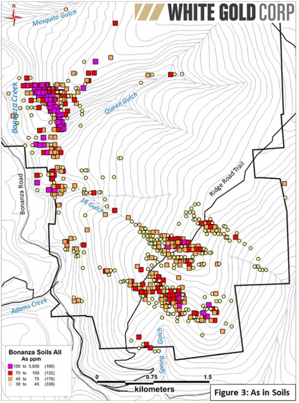
The most pronounced and continuous gold in soil anomalies are located in the southern part of the property, south of Queen Gulch. In particular, the WNW-trending (290°-300°) anomaly associated with 18 Gulch, and a second subparallel anomaly located 750m to the south are continuous across the entire property and collectively represent approximately 6 km of strike length. Two additional linear gold in soil anomalies with the same orientation, with a strike length of 0.9-1.3 km, are located northeast of the 18 Gulch anomaly with the one furthest northeast having no anomalous arsenic association. Between Queen Gulch and Mosquito Gulch located approximately 1.5 km to the north, gold in soil anomalies are NW-trending (315°) and appear to be truncated by post-mineral faults associated with the Queen and Mosquito Gulches (see below). A detailed review and characterization of the various soil anomalies, including differing metal associations with other elements (e.g. As, Sb, Ag, Pb), is ongoing.
Structural Geological Interpretation
A new structural geological interpretation was recently completed on the Bonanza property by consulting structural geologist Dr. Matias Sanchez of Fault Rocks Inc., by integrating airborne magnetics and electromagnetics (EM), and high-resolution drone LiDAR data. Key findings are summarized below, and interpreted structures and gold in soil data are shown in Figures 4-6.
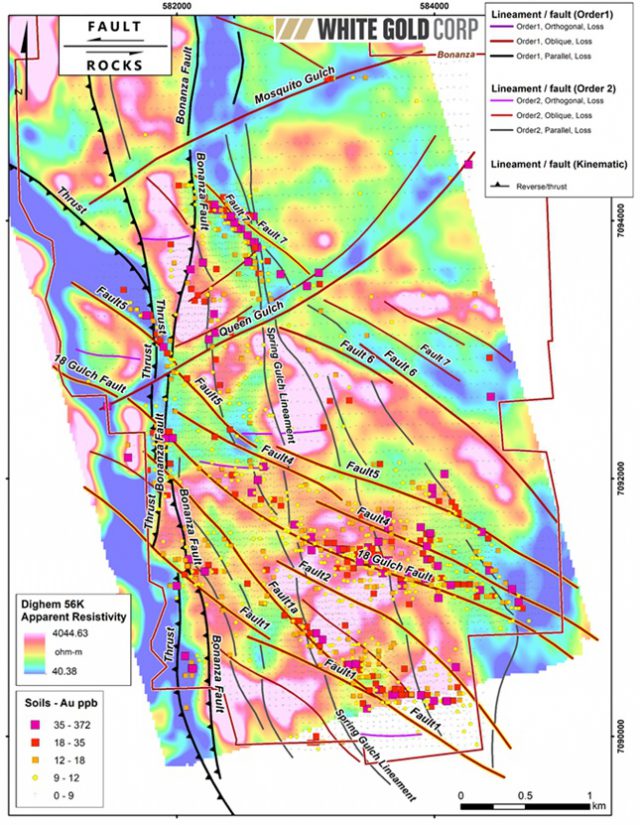


The oldest recognized structure is the Bonanza Fault, a 1st order N- to NNW-trending lineament defined by the Bonanza Creek valley. This structure is interpreted to be a regional scale thrust fault which dips to the west, placing Klondike Schists (hanging wall) over quartz-feldspar augen gneiss (footwall). A series of similarly oriented 2nd and 3rd order magnetic and resistivity lineaments recognized elsewhere across the property are interpreted to possibly represent the principal metamorphic fabric and/or compositional banding.
The most important structures controlling gold mineralization, based on their excellent spatial correlation with anomalous gold and arsenic in soils, are 1st and 2nd order NW-trending faults and fractures which are well-defined by magnetic, resistivity and LiDAR lineaments. These structures are best defined in the southern portion of the property south of Mosquito Gulch, where at least 10 such lineaments have been interpreted. These structures and/or associated splays are continuous across the property and collectively represent a significant strike length of untested potential.
In the Queen Gulch area, a principal NE-trending post-mineral steeply dipping fault is interpreted based on geophysical and topographic features, as well as the abrupt truncation of anomalous soil geochemistry. The subparallel Mosquito Gulch located approximately 1.5 km to the north may represent a similar post-mineral fault.
Exploration Plans for 2021
Exploration work planned for the 2021 season will focus on refining geological and structural interpretations and advancing targets to the drill-ready stage for testing. Ground surveys will include detailed structural mapping and GT Probe sampling across gold in soil anomalies, augmented by mechanical trenching in areas of the highest gold values. High resolution IP-resistivity surveys are also planned in select areas to aid in defining the targets at depth for drill testing.
Acknowledgements
The Company acknowledges and thanks the Government of Yukon for funding a portion of the 2020 exploration program on the Bonanza property through the Yukon Mineral Exploration Program (“YMEP”).
QA/QC
Analytical work for the 2020 soil sampling program on the Bonanza property was performed by Bureau Veritas Canada Ltd., an internationally recognized analytical services provider, at its Vancouver, British Columbia laboratory. Sample preparation was completed at its Whitehorse, Yukon facility, using procedure SS80 (dry at 60° C and sieve 100g to -80 mesh). The analytical procedure used was AQ-201 (15g, aqua regia digestion and ICP-ES/MS analysis).
About White Gold Corp.
The Company owns a portfolio of 21,207 quartz claims across 32 properties covering over 420,000 hectares representing over 40% of the Yukon’s prolific White Gold District. The Company’s flagship White Gold property hosts the Company’s Golden Saddle and Arc deposits which have a mineral resource of 1,139,900 ounces Indicated at 2.28 g/t Au and 402,100 ounces Inferred at 1.39 g/t Au(1). Mineralization on the Golden Saddle and Arc is also known to extend beyond the limits of the current resource estimate. The Company’s recently acquired VG Deposit also hosts a historic Inferred gold resource of 230,000 ounces at 1.65 g/t Au(2). Regional exploration work has also produced several other new discoveries and prospective targets on the Company’s claim packages which border sizable gold discoveries including the Coffee project owned by Newmont Corporation with Measured and Indicated Resources of 2.17 Moz at 1.46 g/t Au, and Inferred Resources of 0.50 Moz at 1.32 g/t Au(3), and Western Copper and Gold Corporation’s Casino project which has Measured and Indicated Resources of 14.5 Moz Au and 7.6 Blb Cu and Inferred Resources of 6.6 Moz Au and 3.3 Blb Cu(4). For more information visit www.whitegoldcorp.ca.
(1) See White Gold Corp. technical report titled “Technical Report for the White Gold Project, Dawson Range, Yukon Canada”, dated July 10, 2020, prepared by Dr. Gilles Arseneau, P.Geo., and Andrew Hamilton, P.Geo., available on SEDAR.
(2) See Comstock Metals Ltd. technical report titled “NI 43-101 TECHNICAL REPORT on the QV PROJECT”, dated August 19, 2014, prepared by Jean Pautler, P.Geo., and Ali Shahkar, P.Eng., available on SEDAR.
(3) See Newmont Corporation press release titled “Newmont Reports 2019 Gold Mineral Reserves of 100 Million Ounces, Largest in Company History”, dated February 13, 2020, available on SEDAR.
(4) See Western Copper and Gold Corporation press release titled “Western Copper and Gold Announces Significant Resource Increase at Casino”, dated July 14, 2020, available on SEDAR.
Qualified Person
Terry Brace, P.Geo. and Vice President of Exploration for the Company is a “qualified person” as defined under National Instrument 43-101 – Standards of Disclosure of Mineral Projects and has reviewed and approved the content of this news release.
For Further Information, Please Contact:
Contact Information:
David D’Onofrio
Chief Executive Officer
White Gold Corp.
(647) 930-1880
ir@whitegoldcorp.ca
To Book a Meeting with Management: https://whitegoldcorp.ca/contact/request-information/
Cautionary Note Regarding Forward Looking Information
This news release contains “forward-looking information” and “forward-looking statements” (collectively, “forward-looking statements”) within the meaning of the applicable Canadian securities legislation. All statements, other than statements of historical fact, are forward-looking statements and are based on expectations, estimates and projections as at the date of this news release. Any statement that involves discussions with respect to predictions, expectations, beliefs, plans, projections, objectives, assumptions, future events or performance (often but not always using phrases such as “expects”, or “does not expect”, “is expected”, “anticipates” or “does not anticipate”, “plans”, “proposed”, “budget”, “scheduled”, “forecasts”, “estimates”, “believes” or “intends” or variations of such words and phrases or stating that certain actions, events or results “may” or “could”, “would”, “might” or “will” be taken to occur or be achieved) are not statements of historical fact and may be forward-looking statements. In this news release, forward-looking statements relate, among other things, the Company’s objectives, goals and exploration activities conducted and proposed to be conducted at the Company’s properties; future growth potential of the Company, including whether any proposed exploration programs at any of the Company’s properties will be successful; exploration results; and future exploration plans and costs and financing availability.
These forward-looking statements are based on reasonable assumptions and estimates of management of the Company at the time such statements were made. Actual future results may differ materially as forward-looking statements involve known and unknown risks, uncertainties and other factors which may cause the actual results, performance or achievements of the Company to materially differ from any future results, performance or achievements expressed or implied by such forward-looking statements. Such factors, among other things, include:
the expected benefits to the Company relating to the exploration conducted and proposed to be conducted at the White Gold properties; the receipt of all applicable regulatory approvals for the Offering; failure to identify any additional mineral resources or significant mineralization; the preliminary nature of metallurgical test results; uncertainties relating to the availability and costs of financing needed in the future, including to fund any exploration programs on the Company’s properties; business integration risks; fluctuations in general macroeconomic conditions; fluctuations in securities markets; fluctuations in spot and forward prices of gold, silver, base metals or certain other commodities; fluctuations in currency markets (such as the Canadian dollar to United States dollar exchange rate); change in national and local government, legislation, taxation, controls, regulations and political or economic developments; risks and hazards associated with the business of mineral exploration, development and mining (including environmental hazards, industrial accidents, unusual or unexpected formations pressures, cave-ins and flooding); inability to obtain adequate insurance to cover risks and hazards; the presence of laws and regulations that may impose restrictions on mining and mineral exploration; employee relations; relationships with and claims by local communities and indigenous populations; availability of increasing costs associated with mining inputs and labour; the speculative nature of mineral exploration and development (including the risks of obtaining necessary licenses, permits and approvals from government authorities); the unlikelihood that properties that are explored are ultimately developed into producing mines; geological factors; actual results of current and future exploration; changes in project parameters as plans continue to be evaluated; soil sampling results being preliminary in nature and are not conclusive evidence of the likelihood of a mineral deposit; title to properties; ongoing uncertainties relating to the COVID-19 pandemic; and those factors described  under the heading “Risks Factors” in the Company’s annual information form dated July 29, 2020 available on SEDAR. Although the forward-looking statements contained in this news release are based upon what management of the Company believes, or believed at the time, to be reasonable assumptions, the Company cannot assure shareholders that actual results will be consistent with such forward-looking statements, as there may be other factors that cause results not to be as anticipated, estimated or intended. Accordingly, readers should not place undue reliance on forward-looking statements and information. There can be no assurance that forward-looking information, or the material factors or assumptions used to develop such forward-looking information, will prove to be accurate. The Company does not undertake to release publicly any revisions for updating any voluntary forward-looking statements, except as required by applicable securities law.
Neither the TSXV nor its Regulation Services Provider (as that term is defined in the policies of the TSXV) accepts responsibility for the adequacy or accuracy of this news release.