
Significant Initial Exploration Target Highlights Large Scale Potential and High Grade of Lake Throssell Sulphate of Potash Project
Exploration success has enabled a sizeable initial high-grade Exploration Target to be estimated at Lake Throssell, with outstanding growth potential
Lake Throssell Sulphate of Potash Project – new high-grade discovery
- Initial JORC compliant Exploration Target defined for the emerging Lake Throssell SOP discovery.
- The Exploration Target covers a strike length of ~70km of the interpreted palaeovalley, within a total strike length of ~112km under tenure, including adjacent tenements under application.
- High grades and multiple potential aquifers encountered throughout the profile, meaning that trenching and deep production bores are possible.
- Additional tenements under application to north and south offer excellent potential to increase the Exploration Target.
The Exploration Target demonstrates the potential for a significant, multi-decade SOP production centre at Lake Throssell, with significant competitive advantages including proximity to infrastructure and services.
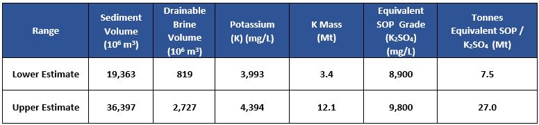
Trigg Mining Limited (ASX: TMG) (Trigg or the Company) is pleased to announce that it has defined an initial Exploration Target of approximately 7.5 to 27 million tonnes at a grade ranging between 9,000Â and 10,000 mg/L SOP equivalent for its 100%-owned Lake Throssell Sulphate of Potash (SOP) Project, located from 170km east of Laverton in Western Australia.
| The potential quantity and grade of the Exploration Target is conceptual in nature. There has been insufficient exploration to estimate a Mineral Resource. It is uncertain if further exploration will result in the estimation of a Mineral Resource. |
The Exploration Target is based on the results of exploration activities undertaken to date on granted tenement E38/3065, encompassing a strike length of ~36km of the interpreted palaeovalley. An additional ~34km of strike length is extrapolated into tenement applications E38/3544, E38/3483, E38/3458 and E38/3537, which are considered to host similar geology and brine characteristics.
Trigg Mining’s Managing Director, Keren Paterson, said: “Defining the Exploration Target is a very significant first step towards evaluating the potential of the enormous opportunity we have in front of us at the Lake Throssell SOP Project. These early results are very encouraging and support our belief in the potential of Lake Throssell to host a sustainable long-life, low-cost source or primary sulphate of potash for global food security.
With this Exploration Target covering the first 70km of the 112km long interpreted palaeovalley, there remains potential to expand on this Exploration Target. With the current air-core drilling program underway and further planned field work, we will continue to expand our knowledge of the potential of this large high-grade SOP system.
Lake Throssell is well positioned for future development with access to established infrastructure with rail access at Leonora, airport and commercial mining support at Laverton and gas pipeline at Yamarna 20km to the south of our tenure. The upgrading of the Great Central Road to become the Outback Highway is well-underway and we anticipate this will reach the mine gate before production commences.
“Based on these very positive results the current air-core drilling program has been expanded to approximately 50 holes and is progressing well. The program is on track for completion by the end of February, weather permitting, and we anticipate receiving the assay results approximately 4 weeks later. These results will then pave the way for our maiden Inferred Mineral Resource estimate for Lake Throssell, the Company’s second Mineral Resource Estimate since listing.”Â
Overview of Exploration Target
The initial Exploration Target for the Lake Throssell SOP Project is set out below and the supporting information and data for the Exploration Target is set out in the following pages of this announcement:
| The potential quantity and grade of the Exploration Target is conceptual in nature. There has been insufficient exploration to estimate a Mineral Resource.  It is uncertain if further exploration will result in the estimation of a Mineral Resource. |
Summary of Exploration
Exploration to date at Lake Throssell has comprised the following programs:
- Lake Surface Hand Auger – 16 drill holes (December 2019);
- Gravity Survey – 200 km of survey (May & August 2020);
- Heli-Rotary Auger Drilling – 26 drill holes (August 2020); and
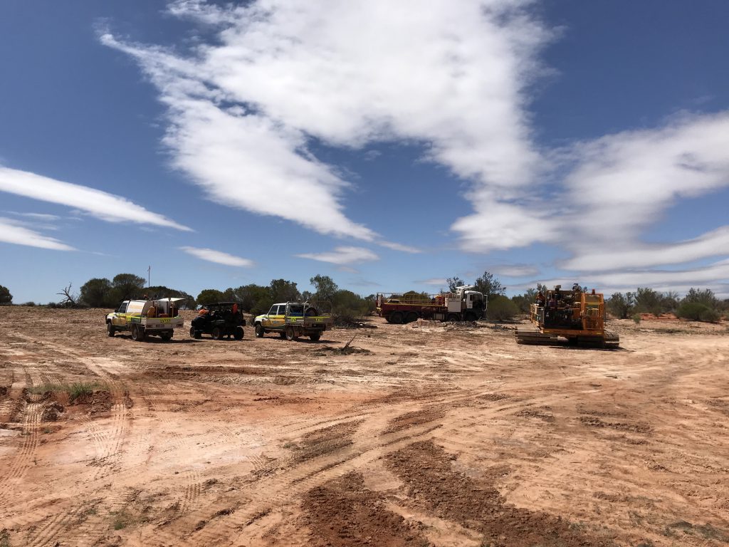
- 50-hole air-core Drilling – On-going (due to be completed in late February 2021).
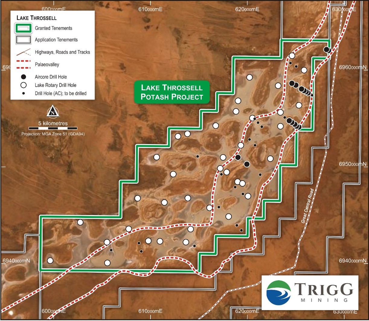
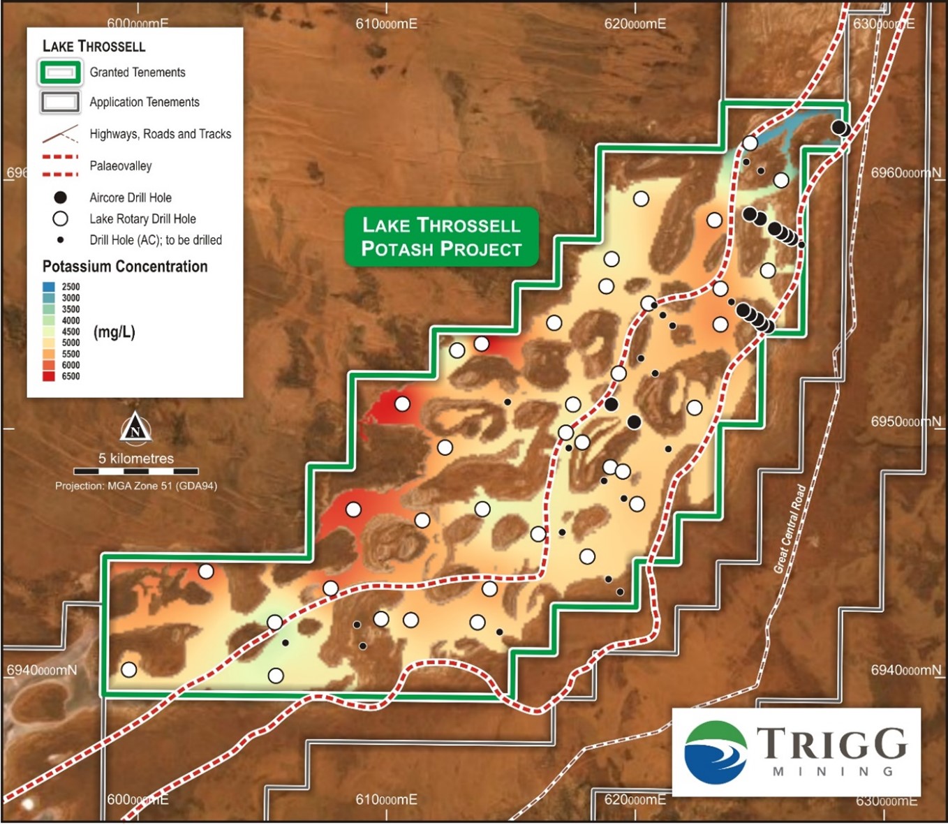
All drill holes completed are presented in Figure 1 and the following sections are a summary of each of the programs.
Hand Auger Drilling and Sampling
A preliminary lake surface auger program was completed in December 2019 to give an indication of brine grade in the shallow lake sediments. A total of 16 auger holes up to 1.2m in depth were completed.
The holes encountered a typical lake surface sequence, dominated by gypsum with silt and clay, with brine at approximately 0.3m below ground level (bgl). Brine samples were obtained from each hole between 0.3m and the end-of-hole.
The brine analysis averaged 5,300mg/L potassium (11,800mg/L SOP equivalent) with the highest result being 6,660mg/L potassium (14,800mg/L SOP equivalent), indicating the presence of high-grade SOP in the lake surface.
The collar locations are presented in Figure 1 and the brine assays and associated geological descriptions are presented in Appendix 1.
Gravity Geophysical Survey
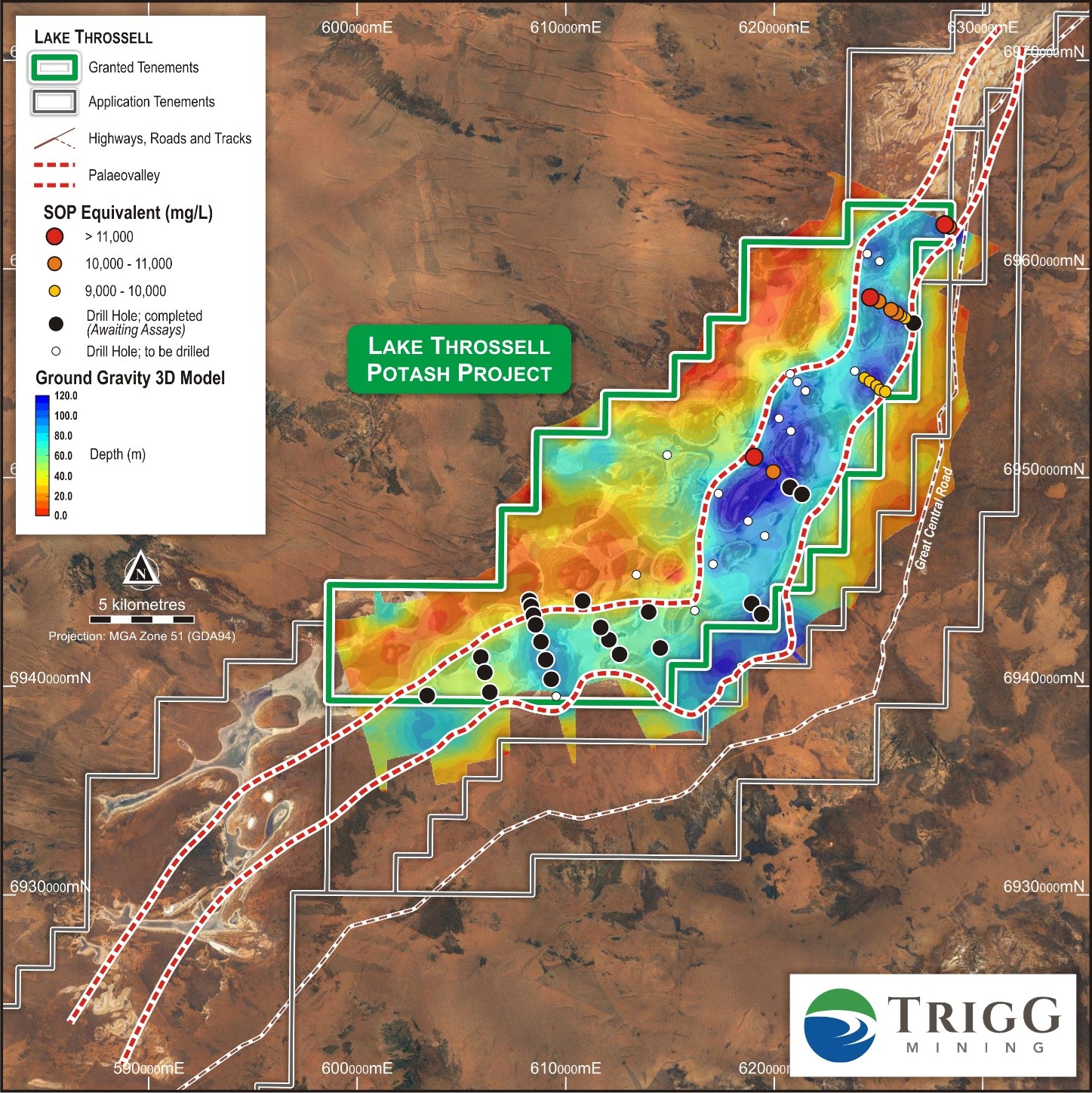
An initial ground gravity survey was completed in May 2020 and followed up with an infill survey in August 2020 with the aim of identifying drilling targets within the palaeovalley system as a first step of identifying a palaeochannel basal aquifer to target with future production bores.
The surveys comprised 1040 stations at approximate 200m spacing on traverses perpendicular to the inferred alignment of the palaeovalley. The gravity data was processed by gridding the Bouguer anomaly and regional separation from the Bouguer anomaly to produce a residual gravity anomaly that is considered to represent the broad palaeovalley geometry.
When compared to the known geology, the gravity highs are well correlated with mapped outcropping Paterson Formation and gravity lows are located within areas of low-lying regolith cover within the Throssell palaeovalley system, providing confidence in the regional model and general understanding of comparative palaeovalley in the region.
Figure 2 shows a map of the residual gravity anomaly. The gravity model was used to generate drill targets for air-core drilling.
Rotary Auger Drilling and Sampling
The program was completed in July 2020 using a heli-rotary auger rig targeting the top sequence of potentially trench-able lake surface sediments to a maximum depth of 10m. The program obtained deeper brine samples and core samples for porosity testing over the entire playa-lake surface, consisting of 26 drill holes. Â Drill-hole locations are presented in Figure 1.
The program encountered gypsum dominated sandy silt and clay in the top 5m. The gypsum layers were up to 0.2m thick and often associated with good to very good brine in-flow rates, inferring that these zones were more highly permeable.
Minor sand and gravel layers were also identified in three holes, with one hole (LTAG19) containing a clay/silt supported sand interval of at least 1.3m with rounded pebbles. A more clay dominated sequence is present below 5m, with less gypsum and increasing density.
As part of the program, two holes were designed to test the characteristics of the surficial sequence within the islands (LTAG04 and LTAG05). Drilling and brine analysis confirming a lack of brine flow, inferring lower permeability and lower grade brine is present within these areas.
Core samples were obtained throughout drilling using Lexan tubes for laboratory sampling and analysis of porosity and permeability.
Brine samples were obtained during the program by bailing the hollow stem of the auger when open to a known interval to provide a representative sample.
Brine was typically encountered at approximately 0.3m below ground level to the end-of-hole. Brine analysis from the rotary auger program returned grades of up to 6,520mg/L potassium (14,500mg/L SOP equivalent), with an average grade of 5,070mg/L potassium (11,300 mg/L SOP equivalent), which are comparable to the hand auger brine analysis. A summary of collar locations, hole depths, encountered geology and brine analysis is presented in Appendix 1.
Air-core Drilling
The air-core drilling program commenced in late November to test aquifer targets at the base of the palaeovalley sequence determined from the gravity survey. The deepest sections of the palaeovalley are considered to be most prospective for sand and gravel aquifer sequences deposited in a palaeochannel environment.
The drill program was delayed due to wet weather with 16 holes completed prior to a break for wet weather on the 21 December for 1,806m to a maximum depth of 130m (Figure 1 and Appendix 1), refer to ASX announcement dated 21 December 2021.
The completed holes are located in the northern portion of the central tenement E38/3065 and have confirmed the presence of a broad palaeovalley system approximately 100m deep with a number of deep aquifer targets of variable thickness.
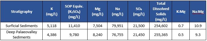
Brine analysis from the program showed that the basal sediments contain brine of similar composition and grade to the surficial sediments, with an average brine grade to date of 4,386 mg/L potassium (9,780 mg/L SOP equivalent), refer to ASX announcement dated 22 January 2021.
The current and expanded drill program comprising a total of 50 holes is expected to be completed at the end of February, which will provide further confirmation on the geology and brine grade distribution on the western and central end of the E38/3065 tenement.
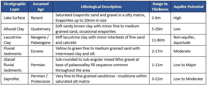
Geological Summary
A summary of the encountered geology of the project to date is presented in Table 1 below.
The geology is consistent with other lakes and palaeovalley sequences in the region. There is an evaporite surface, dominated by gypsum, underlain by more clayey dominated sequences with occasional thin granular and calcrete zones.
These lie on top of a thick sequence of stiff lacustrine clay, which acts as a regionally confining aquitard with very low vertical hydraulic conductivity, meaning it hydraulically separates the upper sediments of the palaeovalley from the basal sediments.
Beneath the lacustrine clay sequence is a low energy fluvial system, of silty fine sand with clay bands with occasional layers of less silty sand. At the base of this low energy fluvial system of Eocene age is the contact with the Permian age Paterson Formation, it is present in the base of the palaeovalley as unconsolidated glacial fluvial sediments of mixed gravel, often with a silty matrix.
Beneath the unconsolidated fluvial glacial deposits is a saprolite zone of weathered bedrock, including sandstone, quartzite and mudstone of either Permian or Proterozoic age. A schematic cross-section of Lake Throssell is presented in Figure 3.
The aquifer potential of each of the stratigraphic layers is provided in Table 1 to provide an indication of potential for brine abstraction, test pumping of each of the aquifer zones is required to confirm their potential. The lake surface can be targeted in future by trenching, whilst production bore targets consist of the Eocene fluvial sediments, Permian glacial fluvial sediments and the saprolite.
Table 1: Current Interpreted Geological Stratigraphy at Lake Throssell
Brine Characteristics
The assay results from the successful hand auger and heli-rotary auger drill programs provide sufficient sampling to map brine potassium concentration across the lake surface.
The average potassium concentration from all samples within the surficial sediments is approximately 5,118mg/L potassium (11,410 mg/L equivalent SOP), the lowest concentration is approximately 2,810mg/L (6,270mg/L equivalent SOP) at LGA26 and the highest concentration is 6,660mg/L (14,850 mg/L equivalent SOP) at LT016.
Higher concentrations appear to be located on the western side of the lake. The potassium concentration distribution across the lake surface is presented in Figure 4.
The brine analysis of deep air-core program is currently limited to the northern extent of Lake Throssell. Â Importantly, the potassium concentration and brine characteristics to date are comparable to the lake surface indicating a continuous brine pool, with minor dilution at depth.
The brine chemistry exhibits favourable characteristics for solar evaporative concentration and lower waste salts, with a low Na:Mg ratio and a high SO4 concentration. The results also suggest that the down-hole potassium grade profile remains reasonably consistent within individual drill-holes, with some minor reduction in potassium and increase in magnesium.
The key average characteristics of the brine from the sampling to date at Lake Throssell are presented in Table 2.
Table 2: Key Average Brine Characteristics of Lake Throssell
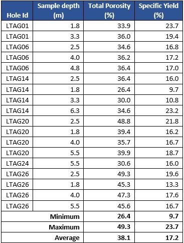
Porosity and Specific Yield
The total volume of brine in a deposit is determined by the total porosity, whilst porosity is made up of specific retention (also known as retained porosity) and specific yield (also known as effective porosity). Specific yield is the percent volume of water that can be drained by gravity from a saturated volume of sediment. Whilst specific retention is the percent volume that is retained under gravity drainage. The specific yield is the ratio used to define the drainable volume of a brine deposit. Portions of specific retention in the lake surface are accessible in addition to the specific yield but require additional modifying factors around lake recharge effects to be determined before quantification.
Total porosity and specific yield have been measured in the laboratory from core plugs obtained from the Lexan tubes during the heli-rotary auger program.
Core plugs of the lake surface sediments were taken at Corelabs, Perth and analysed using the saturated centrifuge method. The results indicate that the sequence is reasonably consistent throughout the profile with an average total porosity of 38.1% and the average specific yield of 17.2%. Results are presented in Table 3.
Table 3: Total Porosity and Specific Yield Estimates
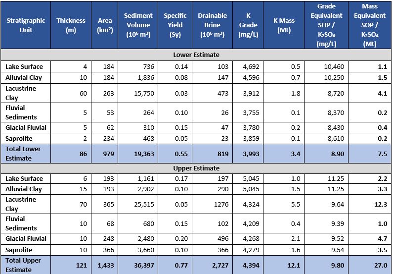
Basis of the Exploration Target
The Exploration Target is an estimate of the exploration potential of a mineral deposit. In a brine hosted deposit, the Exploration Target determines a lower and upper estimate by varying the geological extent, drainable porosity, and brine grade within reasonable bounds based upon the information available as presented in this report.
The geological extent (area and thickness) is determined from a combination of the geological summary in Table 1, the gravity model, the mapped outcropping geology and the conceptual model of regionally described palaeovalley systems.
Islands on the lake surface have been removed from the lake surface and alluvial clay sediment volume calculation. Brine grade range is based on the average brine grades as presented in Table 2 for the upper and lower estimates and have been factored for the pending tenements where no data is presently available.
Drainable porosity has been used to determine brine volume (as recommended by the AMEC Brine Guideline) and has been estimated from the core analysis in Table 4 from specific yield for the surface sediments whilst reasonable estimates based on the lithological descriptions encountered from the deep air-core drilling are provided for all other stratigraphic units.
The Exploration Target encompasses the granted tenement E38/3065 and the surrounding pending tenements currently under application. There has been no work completed on the pending tenements meaning that all estimates are based upon reasonable extrapolation from the work completed on E38/3065.  At the time of reporting Trigg sees no reason why these tenements will not be granted in the future.
The range of the Exploration Target is large due to the largely unknown nature of the geology, brine grade and specific yield throughout the pending tenements. The granted tenement and in particular the lake surface on the granted tenement is reasonably well constrained in comparison.
| The potential quantity and grade of the Exploration Target is conceptual in nature. There has been insufficient exploration to estimate a Mineral Resource.  It is uncertain if further exploration will result in the estimation of a Mineral Resource. |
Table 4: Lake Throssell Exploration Target
Future Work
The air-core drilling program is due to be completed in February 2021, with further brine analysis and soil laboratory analysis of samples to be completed with the aim of estimating a maiden Inferred Mineral Resource for the deposit thereafter.
A lake surface test pitting and trenching program is proposed for Q2 2021, subject to permitting, followed by a water well drilling and testing program to confirm aquifer properties of each of the stratigraphic units, proposed for H2 2021. These are the next steps in increasing the confidence level of the mineral resource estimate towards an Indicated Mineral Resource and will inform future economic studies.
Once the tenements under application are grated exploration activities will be expanded into these areas to test the extents of the Exploration Target.
This announcement was authorised to be given to ASX by the Board of Directors of Trigg Mining Limited.

Managing Director & CEO
Trigg Mining Limited
For more information please contact:
| Keren Paterson
Managing Director Trigg Mining Limited (08) 6114 5685 |
Nicholas Read
Investor and Media Relations Read Corporate (08) 9388 1474 |
APPENDIX 1 – Drill hole and brine analysis tables
Competent Person Statement
The information in this announcement that relates to the Exploration Results and Exploration Target is based upon information compiled by Mr Adam Lloyd, who is employed by Aquifer Resources Pty Ltd, an independent consulting company. Mr Lloyd is a Member of the Australian Institute of Geoscientists and has sufficient experience relevant to the style of mineralisation and type of deposit under consideration and the activity to which is being undertaking to qualify as a Competent Person for reporting of Exploration Results, Mineral Resources and Ore Reserves as defined in the 2012 edition of the “Australasian Code for Reporting of Exploration Results, Mineral Resources and Ore Reserves”. Mr Lloyd consents to the inclusion in the announcement of the matters based upon the information in the form and context in which it appears.