
Western Star Tenders Drill Contract and Submits Exploration Notice to BLM for 17-Hole Drill Program at Eagle Point Tungsten Project, New Mexico

Planned drill program would be the first drilling at Eagle Point in more than 70 years
Western Star Resources Inc. (CSE: WSR) (OTC: WSRIF) (FRA: 4K2) (the “Company” or “Western Star”) is pleased to announce that on October 22, 2026, a 43 CFR 3809 Exploration Notice (the “Notice”) was submitted to the U.S. Bureau of Land Management (“BLM”) Las Cruces District Office for its Eagle Point Tungsten Project (“Eagle Point” or the “Property”) in Hidalgo County, New Mexico. The Notice, prepared and filed on the Company’s behalf by KC Harvey Environmental, LLC, covers a tungsten exploration program of 17 HQ core holes from 12 drill pads, approximately 0.56 mile of temporary connector roads and one laydown area, for a total of 1.71 acres of surface disturbance on BLM-administered and private land.
Submission of the Notice is a key step toward the Company’s planned 17-hole, approximately 6,000-foot drill program, which the Company believes will be the first drilling at Eagle Point in more than 70 years. Drill targets were refined using the results of the Company’s 2026 surface mapping and sampling program, as reported in its news release dated September 30, 2026.
Blake Morgan, CEO and President of Western Star, stated, “Filing our Exploration Notice moves Eagle Point from field mapping and exploration, to only weeks away drilling. Our 2026 surface work gave us clear targets along the granite contact, and this program is designed to test them beneath surface exposures and talus cover. We appreciate the work of KC Harvey Environmental in preparing the submission and look forward to working with the BLM as we advance a domestic tungsten project at a time when secure U.S. supply has become a national priority.”
Key Highlights:
- Notice submitted: A 43 CFR 3809 Exploration Notice was filed with the BLM Las Cruces District Office on October 22, 2026, covering five lode claims in Section 22, T29S R16W, New Mexico Principal Meridian, Hidalgo County.
- Drill program: 17 HQ core holes from 12 drill pads, totalling approximately 6,000 feet, with planned hole depths of 164 to 820 feet, designed to test the steeply dipping skarn contact.
- Small footprint: Total proposed surface disturbance is 1.71 acres, including the 12 drill pads, approximately 0.56 mile of temporary connector roads and a single laydown area. All new disturbance will be reclaimed concurrently with the program.
- Surface access secured: Western Star has a surface use agreement in place with the private surface owner covering road access and all proposed activities on private land.
- Program preparation underway: The Company is tendering drilling contractors and setting up logistics for the program.
Exploration Notice Details
The Notice was submitted under the BLM’s surface management regulations at 43 CFR Subpart 3809, which govern exploration on federal mining claims. The submission includes location, access and project layout figures, claims information, a typical drill pad layout, and GIS shapefiles for the drill pads, roads, laydown area and claim boundary.
Eight of the 12 drill pads, the laydown area and most of the connector roads are on private surface, accounting for approximately 1.35 acres of the proposed disturbance. The remaining four pads and approximately 565 feet of connector road are on BLM-administered land, accounting for approximately 0.36 acres. The Project area is accessed by approximately 3.3 miles of existing roads from U.S. Highway 81, which will be used without upgrades.
Drilling will use a water-based fluid recirculated through a closed-loop centrifuge system, so no in-ground sumps or mud pits are proposed. Drilling water will be purchased from a commercial supplier and trucked to site, with no on-site well or surface water diversion. Each hole will be plugged and abandoned on completion, and drill pads, connector roads and the laydown area will be recontoured, topsoiled and seeded.
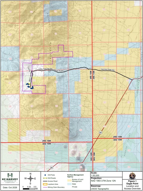
Figure 1: Location and access overview of the Eagle Point Tungsten Project, Hidalgo County, New Mexico, showing the access route from U.S. Highway 81, surface management, the mining claim boundary and the proposed drill pads.
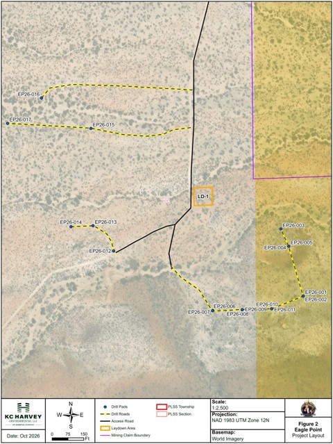
Figure 2: Eagle Point project layout, showing the 17 proposed drill hole locations (EP26-001 to EP26-017) on 12 drill pads, temporary connector roads, laydown area LD-1 and the existing access road.
Next Steps
The Notice describes an operating period from December 2026 through December 2027. Before drilling begins, the Company will submit a Minimal Impact Exploration Operation permit application to the New Mexico Mining and Minerals Division and well and plugging filings to the New Mexico Office of the State Engineer, and will post a reclamation financial guarantee, which is anticipated to be held jointly by the BLM and the Mining and Minerals Division. The Company will also provide the BLM with supplemental vegetation documentation and the results of a cultural resources file search and site inventory.
In parallel, Western Star is tendering drilling contractors, setting up field logistics and finalizing collar locations using its Leapfrog Geo model.
No Mineral Resource has been established at Eagle Point.
Qualified Person
The scientific and technical information contained in this news release has been reviewed and approved by Jacob Anderson, CPG (#12160), MAusIMM (#3089445), an independent consultant to the Company and a Qualified Person as defined by National Instrument 43-101, Standards of Disclosure for Mineral Projects. Mr. Anderson is independent of the Company.
About Western Star Resources
Western Star Resources is a mineral exploration company focused on the acquisition, exploration and advancement of mineral properties, with a growing strategic emphasis on tungsten and critical minerals in the United States. The Company is advancing a portfolio of past-producing tungsten assets in Nevada and New Mexico while maintaining additional exploration exposure through its Western Star property in British Columbia.
Contact Information
On behalf of the Board of Directors,
Blake Morgan, Director, President and CEO
Neither the Canadian Securities Exchange nor its Regulation Services Provider accepts responsibility for the adequacy or accuracy of this press release.
Forward-looking information: Certain statements herein may constitute forward-looking information, including references to the BLM’s review of the Exploration Notice, state permit applications, the posting of a reclamation financial guarantee, the timing, scope and completion of the planned drill program, and future exploration work. Such statements are subject to risks associated with regulatory review and permitting, land access, exploration, operations, weather, and contractor and equipment availability. Forward-looking information is based on the Company’s current expectations and assumptions, including that regulatory reviews will be completed on a timely basis, that required approvals and financial guarantees will be obtained on acceptable terms, and that drilling contractors and equipment will be available as planned. Readers are advised not to place undue reliance on forward-looking information. The Company does not undertake to update forward-looking information except as required by applicable securities laws.